Door County, Wisconsin
| Door County, Wisconsin | |
|---|---|
 Door County Government Center | |
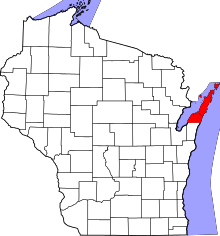 Location in the U.S. state of Wisconsin | |
 Wisconsin's location in the U.S. | |
| Founded | 1861 |
| Named for | Door Peninsula |
| Seat | Sturgeon Bay |
| Largest city | Sturgeon Bay |
| Area | |
| • Total | 2,370 sq mi (6,138 km2) |
| • Land | 482 sq mi (1,248 km2) |
| • Water | 1,888 sq mi (4,890 km2), 80% |
| Population | |
| • (2010) | 27,785 |
| • Density | 58/sq mi (22/km2) |
| Congressional district | 8th |
| Time zone | Central: UTC−6/−5 |
| Website |
www |
Door County is a county in the U.S. state of Wisconsin. As of the 2010 census, the population was 27,785.[1] Its county seat is Sturgeon Bay.[2]
The county was created in 1851 and organized in 1861.[3] It is named after the strait between the Door Peninsula and Washington Island. The dangerous passage, known as Death's Door, is now scattered with shipwrecks, and was known to early French explorers and local Native Americans.
Door County is a popular vacation and tourist destination, especially for residents of Wisconsin and Illinois.[4]
History
The Door County peninsula has been inhabited for about 11,000 years.[5] Artifacts from an ancient village site at Nicolet Bay Beach have been dated to about 400 BCE. This site was occupied by various cultures until about 1300 CE.[6]
Door County's name came from Porte des Morts, anglicized as "Death's Door", or the passage between the tip of the Door County Peninsula and Washington Island.[7] It is a common misconception that the name "Death's Door", or "Porte des Morts", arose from the number of shipwrecks associated with the passage. It was instead the result of Native American tales, heard by early French explorers, related to a failed raid by the Ho-Chunk (Winnebago) tribe to capture Washington Island from the rival Pottawatomie tribe in the early 1600s.[8] A storm arose as the war party was halfway across, capsizing and killing about a third of the Ho-Chunk tribe in the process.
The 18th and 19th centuries saw the immigration and settlement of pioneers, mariners, fishermen and farmers, with the first white settler being Increase Claflin.[9] Economic sustenance came from lumbering and tourism.
During the 19th century, various groups of Native Americans occupied the area that would become Door County and its islands. Beginning in mid-century, these Indians, mostly Potawatomi, were removed from the peninsula by the federal government under the Indian Removal Act of 1830. Later in the 19th century, a fairly large-scale immigration of Belgian Walloons populated a small region in southern portion of the county.[6]

A Civilian Conservation Corps camp was established at Peninsula State Park during the Great Depression. In the summer of 1945, Fish Creek was the site of a German POW camp, under an affiliation with a base camp at Fort Sheridan, Illinois.[10][11][12] The prisoners engaged in construction projects, cut wood, and picked cherries in Peninsula State Park and the surrounding area.[13] Eagle Bluff Lighthouse was constructed in Peninsula State Park in 1868 on orders from President Andrew Johnson, at a cost of $12,000. It was restored by the Door County Historical Society in 1964, and opened to the public.[14]
Geography
According to the U.S. Census Bureau, the county has a total area of 2,370 square miles (6,100 km2), of which 482 square miles (1,250 km2) is land and 1,888 square miles (4,890 km2) (80%) is water.[15] It is the largest county in Wisconsin by total area. The county also has 298 miles (480,000 m) of shoreline. Locals and tourists alike refer to the area as the "Cape Cod of the Midwest".[16] The county covers the majority of the Door Peninsula. With the completion of the Sturgeon Bay Shipping Canal in 1881, the northern half of the peninsula, technically became an island.[14]
Limestone outcroppings of the Niagara Escarpment are visible on both shores of the peninsula, but are larger and more prominent on the Green Bay side as seen at the Bayshore Blufflands. Progressions of dunes have created much of the rest of the shoreline, especially on the easterly side. Flora along the shore provides clear evidence of plant succession. The middle of the peninsula is mostly flat or rolling cultivated land. Soils overlaying the dolomite bedrock are very thin in the northern half of the county; thirty-nine percent of thecCounty is mapped as having less than three feet (about a meter) to bedrock. Beyond the northern tip of the peninsula, the partially submerged ridge forms a number of islands that stretch to the Garden Peninsula in the Upper Peninsula of Michigan. The largest of these islands is Washington Island. Most of these islands form the Town of Washington.
 Door County Sign on Highway 57
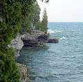 Cave Point County Park
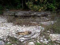
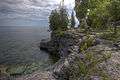 Cave Point County Park
 Cave Point County Park
Adjacent counties
- Kewaunee County - South
- Brown County - Southwest
- Oconto County - West
- Marinette County - Northwest
- Menominee County, Michigan - Northwest
- Delta County, Michigan - North
National protected areas
Demographics
| Historical population | |||
|---|---|---|---|
| Census | Pop. | %± | |
| 1860 | 2,948 | — | |
| 1870 | 4,919 | 66.9% | |
| 1880 | 11,645 | 136.7% | |
| 1890 | 15,082 | 29.5% | |
| 1900 | 17,583 | 16.6% | |
| 1910 | 18,711 | 6.4% | |
| 1920 | 19,073 | 1.9% | |
| 1930 | 18,182 | −4.7% | |
| 1940 | 19,095 | 5.0% | |
| 1950 | 20,870 | 9.3% | |
| 1960 | 20,685 | −0.9% | |
| 1970 | 20,106 | −2.8% | |
| 1980 | 25,029 | 24.5% | |
| 1990 | 25,690 | 2.6% | |
| 2000 | 27,961 | 8.8% | |
| 2010 | 27,785 | −0.6% | |
| Est. 2016 | 27,587 | [17] | −0.7% |
| U.S. Decennial Census[18] 1790–1960[19] 1900–1990[20] 1990–2000[21] 2010–2014[1] | |||
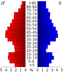
As of the census of 2000,[22] there were 27,961 people, 11,828 households, and 7,995 families residing in the county. The population density was 58 people per square mile (22/km²). There were 19,587 housing units at an average density of 41 per square mile (16/km²). The racial makeup of the county was 97.84% White, 0.19% Black or African American, 0.65% Native American, 0.29% Asian, 0.01% Pacific Islander, 0.33% from other races, and 0.69% from two or more races. 0.95% of the population were Hispanic or Latino of any race. 39.4% were of German and 10.3% Belgian ancestry. A small pocket of Walloon speakers forms the only Walloon-language region outside of Wallonia and its immediate neighbors.[23] Out of a total of 11,828 households, 26.90% had children under the age of 18 living with them, 58.10% were married couples living together, 6.50% had a female householder with no husband present, and 32.40% were non-families. 28.10% of all households were made up of individuals and 12.70% had someone living alone who was 65 years of age or older. The average household size was 2.33 and the average family size was 2.84.
In the county, the population was spread out with 22.10% under the age of 18, 6.10% from 18 to 24, 25.40% from 25 to 44, 27.70% from 45 to 64, and 18.70% who were 65 years of age or older. The median age was 43 years. For every 100 females there were 97.10 males. For every 100 females age 18 and over, there were 94.50 males.
Tourism


Although Door County has a year-round population of about 28,000, it experiences an influx of tourists each summer between Memorial Day and Labor Day. Most businesses are targeted to tourism and operate seasonally. In the summer, the population of Door County may be as high as 250,000. The majority of tourists and summer residents come from the metropolitan areas of Milwaukee, Chicago, Madison, Green Bay, and the Twin Cities.[24] The area has been called "the Cape Cod of the Midwest".[24]
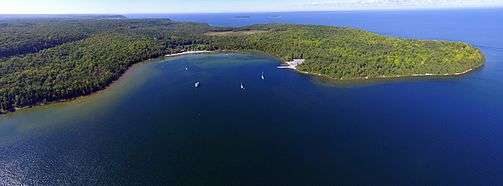
Door County is home to five state parks: Newport State Park, northeast of Ellison Bay; Peninsula State Park, east of Fish Creek; Potawatomi State Park, along Sturgeon Bay; Rock Island State Park, off the tip of the Door Peninsula; and Whitefish Dunes State Park, along Lake Michigan.[25]
Door County has ten lighthouses. Most were built during the 19th century and are listed in the National Register of Historic Places: Baileys Harbor Range Lights; Cana Island Lighthouse; Chambers Island Lighthouse; Eagle Bluff Lighthouse; Pilot Island Lighthouse; Plum Island Range Lights; Pottawatomie Lighthouse; and Sturgeon Bay Canal Lighthouse. The other lighthouses in the county are: Baileys Harbor Lighthouse; Sherwood Point Lighthouse; and the Sturgeon Bay Canal North Pierhead Light.[26]
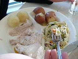
Fish boils, offered at many Door County restaurants, are a popular meal and event for tourists.[27] Other tourist attractions include the Björklunden Norwegian stave church near Baileys Harbor and Al Johnson's Swedish Restaurant with its goats on its grassy roof in Sister Bay.
Door County has a history of cherry growing that dates back to the 19th century.[28] Cherry and apple stands can be found along many of Door County's country roads when in season.[29]
Door County has eight wineries,[30] tasting rooms, three microbreweries, a distillery,[31] and a French-style cider house.[32]
Transportation
Major highways
Airports
- Door County Cherryland Airport (KSUE), located three miles west of Sturgeon Bay, Wisconsin
- Ephraim–Gibraltar Airport (3D2), located one mile southwest of Ephraim, Wisconsin
- Washington Island Airport (2P2), enhances local service.
Communities
City
- Sturgeon Bay (county seat)
Villages
Towns
Census-designated places
Unincorporated communities
Politics
Door County has voted for the winning candidate in every presidential election since 1996.
| Year | Republican | Democratic | Third parties |
|---|---|---|---|
| 2016 | 48.8% 8,580 | 45.6% 8,014 | 5.7% 998 |
| 2012 | 46.0% 8,121 | 53.0% 9,357 | 1.1% 193 |
| 2008 | 40.7% 7,112 | 58.0% 10,142 | 1.3% 227 |
| 2004 | 50.9% 8,910 | 47.8% 8,367 | 1.2% 214 |
| 2000 | 51.3% 7,810 | 43.1% 6,560 | 5.6% 850 |
| 1996 | 40.4% 4,948 | 45.6% 5,590 | 14.0% 1,713 |
| 1992 | 39.7% 5,468 | 34.4% 4,735 | 25.9% 3,574 |
| 1988 | 55.6% 6,907 | 43.7% 5,425 | 0.7% 90 |
| 1984 | 67.4% 8,264 | 31.9% 3,916 | 0.7% 91 |
| 1980 | 55.2% 7,170 | 38.2% 4,961 | 6.6% 851 |
| 1976 | 57.4% 6,557 | 39.9% 4,553 | 2.7% 307 |
| 1972 | 64.3% 6,503 | 33.9% 3,430 | 1.9% 188 |
| 1968 | 63.3% 5,647 | 30.6% 2,728 | 6.1% 541 |
| 1964 | 49.2% 4,289 | 50.7% 4,416 | 0.1% 9 |
| 1960 | 61.5% 5,790 | 38.4% 3,610 | 0.2% 14 |
| 1956 | 78.0% 6,722 | 21.6% 1,859 | 0.5% 41 |
| 1952 | 80.8% 7,621 | 19.0% 1,790 | 0.2% 19 |
| 1948 | 65.8% 4,911 | 32.7% 2,440 | 1.5% 108 |
| 1944 | 68.3% 5,668 | 31.3% 2,599 | 0.5% 38 |
| 1940 | 66.1% 5,461 | 33.3% 2,750 | 0.6% 49 |
| 1936 | 41.1% 3,146 | 51.6% 3,952 | 7.4% 566 |
| 1932 | 37.0% 2,488 | 61.6% 4,149 | 1.4% 97 |
| 1928 | 59.3% 3,636 | 40.0% 2,456 | 0.7% 42 |
| 1924 | 38.6% 1,891 | 4.8% 235 | 56.6% 2,778 |
| 1920 | 88.3% 3,817 | 8.9% 385 | 2.8% 119 |
| 1916 | 56.3% 1,656 | 40.9% 1,204 | 2.9% 84 |
| 1912 | 41.2% 1,167 | 27.1% 769 | 31.7% 900 |
| 1908 | 73.9% 2,463 | 23.3% 778 | 2.8% 93 |
| 1904 | 80.5% 2,689 | 15.4% 515 | 4.1% 136 |
| 1900 | 76.3% 2,362 | 21.8% 674 | 1.9% 60 |
| 1896 | 71.3% 2,402 | 26.6% 895 | 2.1% 72 |
| 1892 | 58.2% 1,596 | 36.7% 1,007 | 5.1% 140 |
See also
References
- 1 2 "State & County QuickFacts". United States Census Bureau. Archived from the original on July 9, 2011. Retrieved January 18, 2014.
- ↑ "Find a County". National Association of Counties. Archived from the original on 2011-05-31. Retrieved 2011-06-07.
- ↑ "Wisconsin: Individual County Chronologies". Wisconsin Atlas of Historical County Boundaries. The Newberry Library. 2007. Retrieved August 13, 2015.
- ↑ Rebecca L. Schewe; Donald R. Field; Deborah J. Frosch; Gregory Clendenning; Dana Jensen (15 May 2012). Condos in the Woods: The Growth of Seasonal and Retirement Homes in Northern Wisconsin. University of Wisconsin Pres. pp. 22–. ISBN 978-0-299-28533-3.
- ↑ Long, C.A. (2008). The Wild Mammals of Wisconsin. Pensoft Series Faunistica. Coronet Books Incorporated. p. 25. ISBN 978-954-642-313-9. Retrieved 2017-04-23.
- 1 2 Soucek, G. (2011). Door County Tales: Shipwrecks, Cherries and Goats on the Roof. American Chronicles. Arcadia Publishing Incorporated. ISBN 978-1-61423-383-1. Retrieved 2017-04-23.
- ↑ Gannett, Henry (1905). The Origin of Certain Place Names in the United States. Washington, D.C.: U.S. Government Printing Office. Retrieved May 7, 2018 – via Google Books.
- ↑ Kohl, Cris & Joan Forsberg, Shipwrecks at Death's Door, Page 10.
- ↑ Hjalmar Holand. History of Door County Wisconsin, The County Beautiful. Chicago: S. J. Clarke, 1917, p. 77.
- ↑ Mariah Goode. "The Harvest of 1945: German POW Camps Filled Door County’s Labor Shortage". Door County Pulse, July 1, 2005.
- ↑ cheyenne Lentz. "Story Of Wisconsin's German POWs Is A Piece Of Hidden History, Author Says". Wisconsin Public Radio, June 23, 2015.
- ↑ Damien Jaques. "Cherry picking with German POWs in Door County". On Milwaukee, July 9, 2012.
- ↑ Tishler, W.H. (2006). Door County's Emerald Treasure: A History of Peninsula State Park. Wisconsin Land and Life. University of Wisconsin Press. ISBN 978-0-299-22073-0. Retrieved 2017-04-23.
- 1 2 Wardius, K.; Wardius, B. (2013). Wisconsin Lighthouses: A Photographic and Historical Guide, Revised Edition. Wisconsin Historical Society Press. p. 100-25. ISBN 978-0-87020-610-8. Retrieved 2017-04-23.
- ↑ "2010 Census Gazetteer Files". United States Census Bureau. August 22, 2012. Archived from the original on September 4, 2015. Retrieved 2015-08-04.
- ↑ Lyttle, Bethany (September 11, 2008). "The Cape Cod of the Midwest". New York Times. Retrieved 23 April 2017.
- ↑ "Population and Housing Unit Estimates". Archived from the original on May 29, 2017. Retrieved June 9, 2017.
- ↑ "U.S. Decennial Census". United States Census Bureau. Archived from the original on 2015-05-12. Retrieved 2015-08-04.
- ↑ "Historical Census Browser". University of Virginia Library. Archived from the original on August 16, 2012. Retrieved August 4, 2015.
- ↑ Forstall, Richard L., ed. (March 27, 1995). "Population of Counties by Decennial Census: 1900 to 1990". United States Census Bureau. Archived from the original on July 18, 2015. Retrieved August 4, 2015.
- ↑ "Census 2000 PHC-T-4. Ranking Tables for Counties: 1990 and 2000" (PDF). United States Census Bureau. April 2, 2001. Archived (PDF) from the original on December 18, 2014. Retrieved 2015-08-04.
- ↑ "American FactFinder". United States Census Bureau. Archived from the original on 2013-09-11. Retrieved 2011-05-14.
- ↑ "Belgian-American Research Collection" Archived 2011-01-06 at the Wayback Machine., University of Wisconsin
- 1 2 Lyttle, Bethany (2008-09-11). "'The Cape Cod of the Midwest'". The New York Times. Archived from the original on 2017-10-22. Retrieved 2008-09-25.
- ↑ Five State Parks in Door County Archived 2018-03-31 at the Wayback Machine.. Travel Wisconsin, Wisconsin Department of Tourism.
- ↑ More Door County Lighthouses Archived 2018-05-07 at the Wayback Machine.. Door County Maritime Museum.
- ↑ Joy Marquardt. "Fish boils serve up food, fun". Wausau Daily Herald, August 31, 2016.
- ↑ Apple & Cherry Orchards: Door County Wisconsin Archived October 6, 2008, at the Wayback Machine.
- ↑ "Archived copy". Archived from the original on 2014-12-07. Retrieved 2014-12-04.
- ↑ "Door County Wine Trail". Door County Visitor Bureau. Retrieved May 7, 2018.
- ↑ "Archived copy". Archived from the original on 2014-12-09. Retrieved 2014-12-04.
- ↑ "About Us - Island Orchard Cider". islandorchardcider.com. Archived from the original on 22 October 2017. Retrieved 7 May 2018.
- ↑ Leip, David. "Dave Leip's Atlas of U.S. Presidential Elections". uselectionatlas.org. Archived from the original on 23 March 2018. Retrieved 7 May 2018.
Further reading
- Holand, Hjalmar R. History of Door County, Wisconsin, The County Beautiful. Chicago: S. J. Clarke, 1917.
- Martin, Chas. I. History of Door County, Wisconsin. Sturgeon Bay, Wis.: Expositor Job Print, 1881.
External links
| Wikimedia Commons has media related to Door County, Wisconsin. |

- Door County government website
- Door County map from the Wisconsin Department of Transportation
- Door County Historical Society
- Door County Visitor Bureau
- Road Trip to Door County Video produced by Wisconsin Public Television
Places adjacent to Door County, Wisconsin | ||||||||||
|---|---|---|---|---|---|---|---|---|---|---|
| ||||||||||
Municipalities and communities of Door County, Wisconsin, United States | ||
|---|---|---|
| City | | |
| Villages | ||
| Towns | ||
| CDPs | ||
| Unincorporated communities | ||
| Footnotes | ‡This populated place also has portions in an adjacent county or counties | |
