Paxico, Kansas
| Paxico, Kansas | |
|---|---|
| City | |
 Old railroad depot in Paxico (2009) | |
 Location within Wabaunsee County and Kansas | |
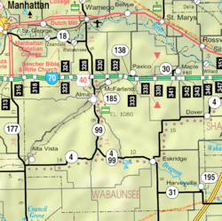 KDOT map of Wabaunsee County (legend) | |
| Coordinates: 39°4′5″N 96°10′4″W / 39.06806°N 96.16778°WCoordinates: 39°4′5″N 96°10′4″W / 39.06806°N 96.16778°W | |
| Country | United States |
| State | Kansas |
| County | Wabaunsee |
| Area[1] | |
| • Total | 0.14 sq mi (0.36 km2) |
| • Land | 0.14 sq mi (0.36 km2) |
| • Water | 0 sq mi (0 km2) |
| Elevation | 991 ft (302 m) |
| Population (2010)[2] | |
| • Total | 221 |
| • Estimate (2016)[3] | 213 |
| • Density | 1,600/sq mi (610/km2) |
| Time zone | UTC-6 (CST) |
| • Summer (DST) | UTC-5 (CDT) |
| ZIP code | 66526 |
| Area code | 785 |
| FIPS code | 20-54950 [4] |
| GNIS ID | 0476610 [5] |
| Website | Paxico Merchants |
Paxico is a city in Wabaunsee County, Kansas, United States. As of the 2010 census, the city population was 221.[6]
History
.jpg)
Paxico was originally called Strong Mill, and under the latter name was established in 1879 about one mile east of the present town site.[7] A post office was set up and named Paxico, in honor of the Potawatomi medicine man Pashqua.[7][8][9] When the railroad was built though the area in 1886, the town moved in order to be alongside it.[7]
In 1887, the Chicago, Kansas and Nebraska Railway built a main line from Topeka through Paxico to Herington.[10] The Chicago, Kansas and Nebraska Railway was foreclosed in 1891 and taken over by Chicago, Rock Island and Pacific Railway, which shut down in 1980 and reorganized as Oklahoma, Kansas and Texas Railroad, merged in 1988 with Missouri Pacific Railroad, merged in 1997 with Union Pacific Railroad. Most locals still refer to this railroad as the "Rock Island".
Geography
According to the United States Census Bureau, the city has a total area of 0.14 square miles (0.36 km2), all of it land.[1]
Demographics
| Historical population | |||
|---|---|---|---|
| Census | Pop. | %± | |
| 1920 | 249 | — | |
| 1930 | 261 | 4.8% | |
| 1940 | 237 | −9.2% | |
| 1950 | 196 | −17.3% | |
| 1960 | 276 | 40.8% | |
| 1970 | 216 | −21.7% | |
| 1980 | 168 | −22.2% | |
| 1990 | 174 | 3.6% | |
| 2000 | 211 | 21.3% | |
| 2010 | 221 | 4.7% | |
| Est. 2016 | 213 | [3] | −3.6% |
| U.S. Decennial Census | |||
Paxico is part of the Topeka Metropolitan Statistical Area.
2010 census
As of the census[2] of 2010, there were 221 people, 85 households, and 58 families residing in the city. The population density was 1,578.6 inhabitants per square mile (609.5/km2). There were 93 housing units at an average density of 664.3 per square mile (256.5/km2). The racial makeup of the city was 91.0% White, 1.8% African American, 0.5% Native American, and 6.8% from two or more races. Hispanic or Latino of any race were 5.4% of the population.
There were 85 households of which 35.3% had children under the age of 18 living with them, 54.1% were married couples living together, 5.9% had a female householder with no husband present, 8.2% had a male householder with no wife present, and 31.8% were non-families. 24.7% of all households were made up of individuals and 7.1% had someone living alone who was 65 years of age or older. The average household size was 2.60 and the average family size was 3.00.
The median age in the city was 36.3 years. 28.5% of residents were under the age of 18; 6.3% were between the ages of 18 and 24; 26.3% were from 25 to 44; 25.7% were from 45 to 64; and 13.1% were 65 years of age or older. The gender makeup of the city was 51.1% male and 48.9% female.
2000 census
As of the census[4] of 2000, there were 211 people, 82 households, and 55 families residing in the city. The population density was 1,501.9 people per square mile (581.9/km²). There were 90 housing units at an average density of 640.6 per square mile (248.2/km²). The racial makeup of the city was 94.31% White, 0.95% African American, 0.95% from other races, and 3.79% from two or more races. Hispanic or Latino of any race were 5.21% of the population.
There were 82 households out of which 31.7% had children under the age of 18 living with them, 53.7% were married couples living together, 9.8% had a female householder with no husband present, and 32.9% were non-families. 29.3% of all households were made up of individuals and 14.6% had someone living alone who was 65 years of age or older. The average household size was 2.57 and the average family size was 3.22.
In the city, the population was spread out with 29.4% under the age of 18, 7.6% from 18 to 24, 27.5% from 25 to 44, 22.3% from 45 to 64, and 13.3% who were 65 years of age or older. The median age was 34 years. For every 100 females, there were 102.9 males. For every 100 females age 18 and over, there were 101.4 males.
The median income for a household in the city was $41,250, and the median income for a family was $45,000. Males had a median income of $38,750 versus $26,250 for females. The per capita income for the city was $14,274. About 5.8% of families and 10.3% of the population were below the poverty line, including 9.5% of those under the age of eighteen and 8.7% of those sixty five or over.
Education
School unification consolidated Alma, Maple Hill, McFarland and Paxico schools forming USD 329 Wabaunsee. Wabaunsee High School is located in Alma. The Wabaunsee High School mascot is Wabaunsee Chargers.[11]
Paxico High School was closed through school unification. The Paxico High School mascot was Paxico Pirates.[12]
Area events
References
- 1 2 "US Gazetteer files 2010". United States Census Bureau. Archived from the original on January 24, 2012. Retrieved 2012-07-06.
- 1 2 "American FactFinder". United States Census Bureau. Retrieved 2012-07-06.
- 1 2 "Population and Housing Unit Estimates". Retrieved June 9, 2017.
- 1 2 "American FactFinder". United States Census Bureau. Archived from the original on 2013-09-11. Retrieved 2008-01-31.
- ↑ "US Board on Geographic Names". United States Geological Survey. 2007-10-25. Retrieved 2008-01-31.
- ↑ "2010 City Population and Housing Occupancy Status". U.S. Census Bureau. Archived from the original on July 21, 2011. Retrieved December 2, 2011.
- 1 2 3 Blackmar, Frank Wilson (1912). Kansas: A Cyclopedia of State History, Volume 2. Standard Publishing Company.
- ↑ Heim, Michael (2007). Exploring Kansas Highways. p. 42.
- ↑ "Profile for Paxico, Kansas". ePodunk. Retrieved 27 June 2014.
- ↑ Rock Island Rail History
- ↑ "Wabaunsee USD 329". USD 329. Retrieved 4 January 2017.
- ↑ "Playoffs Move to Semifinals", The Emporia Gazette, 15 November 1973, p.5.
- ↑ http://paxicomerchants.com/carshow.html
- ↑ Paxico Blues Fest
External links
| Wikimedia Commons has media related to Paxico, Kansas. |
- City
- Schools
- USD 329, local school district
- Maps
- Paxico City Map, KDOT
Municipalities and communities of Wabaunsee County, Kansas, United States | ||
|---|---|---|
| Cities | 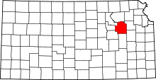 | |
| Unincorporated communities | ||
| Ghost towns | ||
| Footnotes | ‡This populated place also has portions in an adjacent county or counties | |