Mount Olive, Stokes County, North Carolina
| Mount Olive | |
|---|---|
| Unincorporated community | |
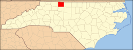
 Mount Olive Location within the state of North Carolina  Mount Olive Mount Olive (the US) | |
| Coordinates: 36°19′40″N 80°20′11″W / 36.32778°N 80.33639°WCoordinates: 36°19′40″N 80°20′11″W / 36.32778°N 80.33639°W | |
| Country | United States |
| State | North Carolina |
| County | Stokes |
| Elevation | 1,129 ft (344 m) |
| Time zone | UTC-5 (Eastern (EST)) |
| • Summer (DST) | UTC-4 (EDT) |
| ZIP code | 27021 |
| GNIS feature ID | 990458 |
Mount Olive is an unincorporated community in Stokes County, North Carolina, United States, approximately five miles north of King on North Carolina State Highway 66.
It is not to be confused with Mount Olive, Wayne County, North Carolina.
Municipalities and communities of Stokes County, North Carolina, United States | ||
|---|---|---|
| City |
|  |
| Towns | ||
| Village | ||
| Townships | ||
| CDPs | ||
| Other unincorporated communities |
| |
| Footnotes | ‡This populated place also has portions in an adjacent county or counties. | |
This article is issued from
Wikipedia.
The text is licensed under Creative Commons - Attribution - Sharealike.
Additional terms may apply for the media files.