Gap, North Carolina
| Gap | |
|---|---|
| Unincorporated community | |
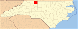
 Gap Location within the state of North Carolina | |
| Coordinates: 36°23′12″N 80°19′31″W / 36.38667°N 80.32528°WCoordinates: 36°23′12″N 80°19′31″W / 36.38667°N 80.32528°W | |
| Country | United States |
| State | North Carolina |
| County | Stokes |
| Time zone | UTC-5 (Eastern (EST)) |
| • Summer (DST) | UTC-4 (EDT) |
| ZIP codes | 27021 & 27053 |
Gap is an unincorporated community in Stokes County, North Carolina, United States, approximately 5 miles WSW of Danbury, North Carolina, near Hanging Rock State Park, on North Carolina State Highway 66.
Municipalities and communities of Stokes County, North Carolina, United States | ||
|---|---|---|
| City |
|  |
| Towns | ||
| Village | ||
| Townships | ||
| CDPs | ||
| Other unincorporated communities |
| |
| Footnotes | ‡This populated place also has portions in an adjacent county or counties. | |
This article is issued from
Wikipedia.
The text is licensed under Creative Commons - Attribution - Sharealike.
Additional terms may apply for the media files.