North Carolina Highway 35
| ||||
|---|---|---|---|---|
 | ||||
| Route information | ||||
| Maintained by NCDOT | ||||
| Length | 20.5 mi[1] (33.0 km) | |||
| Existed | 1940[2] – present | |||
| Major junctions | ||||
| South end |
| |||
|
| ||||
| North end |
| |||
| Location | ||||
| Counties | Hertford, Northampton | |||
| Highway system | ||||
| ||||

North Carolina Highway 35 (NC 35) is a primary state highway in the U.S. state of North Carolina.
Route description
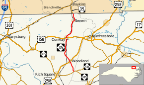
Starting from its southern terminus at NC 305/NC 561 near Tri-County Airport in Mintons Store of western Hertford County, the route immediately enters Northampton County as it progresses northward. In the town of Woodland, NC 35 joins US 258 as Woodland's main street, before turning north again only a couple city blocks later. The road continues north through the towns of Conway and Severn before it turns into Virginia State Route 35 at the Virginia state line. Much of the route runs mostly parallel to the North Carolina and Virginia Railroad and crosses it several times.
History
Originally, NC 35 was created around 1930 as the route that present-day NC 45 follows from US 13 to US 17. However, Virginia renumbered its routes in 1940, and North Carolina followed suit to remain consistent.[2]
Major intersections
| County | Location | mi[1] | km | Destinations | Notes |
|---|---|---|---|---|---|
| Hertford | | 0.0 | 0.0 | ||
| Northampton | Woodland | 3.4 | 5.5 | South end of concurrency with US 258 | |
| 3.6 | 5.8 | North end of concurrency with US 258 | |||
| Conway | 11.6 | 18.7 | |||
| Southampton | | 20.5 | 33.0 | Virginia state line | |
1.000 mi = 1.609 km; 1.000 km = 0.621 mi
| |||||
See also
- North Carolina Bicycle Route 4 - Concurrent with NC 35 through Severn
References
- 1 2 Google (February 11, 2016). "North Carolina Highway 35" (Map). Google Maps. Google. Retrieved February 11, 2016.
- 1 2 NCRoads Annex - NC 35 Archived March 7, 2008, at the Wayback Machine.
External links

- NCRoads.com: N.C. 35