Hertford, North Carolina
| Hertford, North Carolina | |
|---|---|
| Town | |
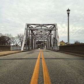 Hertford's famous 'S-Bridge,' | |
 Location of Hertford, North Carolina | |
| Coordinates: 36°11′14″N 76°28′20″W / 36.18722°N 76.47222°WCoordinates: 36°11′14″N 76°28′20″W / 36.18722°N 76.47222°W | |
| Country | United States |
| State | North Carolina |
| County | Perquimans |
| Incorporated | 1758 |
| Government | |
| • Mayor | Horace C. Reid, Jr. |
| Area | |
| • Total | 2.7 sq mi (7.0 km2) |
| • Land | 2.7 sq mi (7.0 km2) |
| • Water | 0.0 sq mi (0.1 km2) |
| Elevation | 10 ft (3 m) |
| Population (2010) | |
| • Total | 2,143 |
| • Estimate (2016)[1] | 2,126 |
| • Density | 790/sq mi (310/km2) |
| Time zone | UTC-5 (Eastern (EST)) |
| • Summer (DST) | UTC-4 (EDT) |
| ZIP codes | 27930, 27944 |
| Area code(s) | 252 |
| FIPS code | 37-30900[2] |
| GNIS feature ID | 1025382[3] |
| Website | www.townofhertfordnc.com |
Hertford is a town in Perquimans County, North Carolina, United States. The population was 2,143 as of the 2010 census. It is the county seat of Perquimans County.[4] Hertford is located in North Carolina's Inner Banks region and is part of both the Elizabeth City Micropolitan Statistical Area and the Hampton Roads region. It is named after the county town of Hertford, England.
History
Hertford was originally incorporated in 1758 as the county seat for Perquimans County, first inhabited by the Yeopim Indians. County records show that the Yeopim chief Kalcacenin sold land to George Durant at the river mouth in March 1662, adjacent to land he had already sold to Samuel Pricklove.[5] The area was settled soon afterwards, and a brick house on the site, the Newbold-White House, has been dated by dendrochronology to 1730; it is the oldest known brick structure in the state.
Through the first part of the 20th century, Hertford thrived as a lumber town, making good use of the nearby river. The bridge that spanned the river was a floating bridge, made of steel and wood. When a boat came near and wanted passage, the bridge would be unhooked from one bank and allowed to float out of the way. When the boat had passed, lines were used to haul the free end of the bridge in and reconnect it. An swing bridge with S-shaped approaches is in use today. Local lore claims its shape is unique in the US, but the Blaine Hill "S" Bridge predates it by over a century.
Hertford is the hometown of baseball pitcher Catfish Hunter. Disc jockey Wolfman Jack is buried in nearby Belvidere, and the record company he started is still located in Hertford.
The Church of the Holy Trinity, Cove Grove, Fletcher-Skinner-Nixon House and Outbuildings, Hertford Historic District, Land's End, Newbold-White House, Samuel Nixon House, Old Neck Historic District, Perquimans County Courthouse, and Sutton-Newby House are listed on the National Register of Historic Places.[6]
Geography
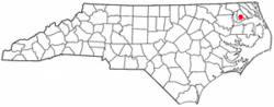
Hertford is located at 36°11′14″N 76°28′20″W / 36.18722°N 76.47222°W (36.187292, -76.472345).[7]
According to the United States Census Bureau, the town has a total area of 2.7 square miles (7.0 km2), of which, 2.7 square miles (7.0 km2) of it is land and 0.04 square miles (0.10 km2) of it (0.74%) is water.
Hertford is 150 miles (240 km) east of Raleigh.[8]
Hertford is also 57 miles (92 km) south of Norfolk.
Demographics
| Historical population | |||
|---|---|---|---|
| Census | Pop. | %± | |
| 1850 | 369 | — | |
| 1870 | 486 | — | |
| 1880 | 661 | 36.0% | |
| 1890 | 733 | 10.9% | |
| 1900 | 1,382 | 88.5% | |
| 1910 | 1,841 | 33.2% | |
| 1920 | 1,704 | −7.4% | |
| 1930 | 1,914 | 12.3% | |
| 1940 | 1,959 | 2.4% | |
| 1950 | 2,096 | 7.0% | |
| 1960 | 2,068 | −1.3% | |
| 1970 | 2,023 | −2.2% | |
| 1980 | 1,941 | −4.1% | |
| 1990 | 2,105 | 8.4% | |
| 2000 | 2,070 | −1.7% | |
| 2010 | 2,143 | 3.5% | |
| Est. 2016 | 2,126 | [1] | −0.8% |
| U.S. Decennial Census[9] | |||
As of the census[2] of 2010, there were 2,143 people, 875 households, 553 families, and 1,062 housing units residing in the town. The racial makeup of the town was 48.1% African American, 46.5% white, 0.4% Asian, 0.1% Native American, 3.5% some other race, and 1.4% from two or more races. Hispanic Latino of any race were 4.8% of the population.
There were 875 households out of which 26.5% had children under the age of 18 living with them, 33.9% were married couples living together, 25.8% had a female householder with no husband present, and 36.8% were non-families. 32.8% of all households had individuals under 18 and 31% had someone living alone who was 65 years of age or older. The average household size was 2.38 and the average family size was 3.01.
In the town, the population was spread out with 27.7% with an age of 19 or younger, 13.7% in their twenties, 14.8% from 30 to 44, 25.3% from 45 to 64, and 18.5% who were 65 years of age or older. The median age was 38.6 years. For every 100 females, there were 79.0 males.
In 2008, the median income for a household in the town was $19,681, and the median income for a family was $24,524. Males had a median income of $24,803 versus $17,938 for females. The per capita income for the town was $13,502. About 33.6% of families and 39.2% of the population were below the poverty line, including 56.6% of those under age 18 and 21.0% of those age 65 or over.
Transportation
Hertford is served by U.S. Route 17 (US 17) which connects the town with Edenton to the south and Elizabeth City to the north. A business route of US 17 also exists, which connects Hertford to the neighboring town of Winfall and crosses over the Perquimans River on the famous 'S-Bridge.'
NC Highway 37 also travels through Hertford, concurrent with US 17.
Local public bus transportation is provided by the Inter-County Public Transportation Authority (ICPTA), with service to Pasquotank, Perquimans, Camden, Chowan, and Currituck counties.[10]
Education
- Perquimans County Schools
- Hertford Grammar School serving grades 3-5
- Perquimans County High School serving grades 9-12
Grades PK-2 and 6-8 are served by the county schools located in Winfall.
Industry
Agriculture is the chief industry of the area.
The CIA counter terrorism training facility known as Harvey Point is located near Hertford.
Notable Residents
- Jim "Catfish" Hunter, Hall of Fame baseball player who helped lead the New York Yankees and Oakland Athletics to World Series titles.
References
- 1 2 "Population and Housing Unit Estimates". Retrieved June 9, 2017.
- 1 2 "American FactFinder". United States Census Bureau. Retrieved 2008-01-31.
- ↑ "US Board on Geographic Names". United States Geological Survey. 2007-10-25. Retrieved 2008-01-31.
- ↑ "Find a County". National Association of Counties. Archived from the original on 2011-05-31. Retrieved 2011-06-07.
- ↑ Boddie, Seventeenth Century Isle of Wight, p. 126.
- ↑ National Park Service (2010-07-09). "National Register Information System". National Register of Historic Places. National Park Service.
- ↑ "US Gazetteer files: 2010, 2000, and 1990". United States Census Bureau. 2011-02-12. Retrieved 2011-04-23.
- ↑ "Six brothers arrested for molesting younger sister in NC for over a decade." Associated Press at Syracuse.com. May 14, 2014. Retrieved on May 28, 2014.
- ↑ "Census of Population and Housing". Census.gov. Archived from the original on May 12, 2015. Retrieved June 4, 2015.
- ↑ http://www.icpta.net/about/
External links
Municipalities and communities of Perquimans County, North Carolina, United States | ||
|---|---|---|
| Towns |  | |
| Unincorporated communities | ||