Interstate 87 (North Carolina)
| ||||
|---|---|---|---|---|
|
I-87 highlighted in red | ||||
| Route information | ||||
| Maintained by NCDOT | ||||
| Length | 10.4 mi (16.7 km) | |||
| Existed | September 5, 2017 – present | |||
| Major junctions | ||||
| South end |
| |||
| ||||
| North end | Rolesville Road in Wendell | |||
| Location | ||||
| Counties | Wake | |||
| Highway system | ||||
| ||||

Interstate 87 (I-87) is a partially completed Interstate Highway in the U.S. state of North Carolina. Currently serving eastern Wake County, between Raleigh and Wendell, it is planned to continue northeast through Rocky Mount, Williamston and Elizabeth City, ending in Norfolk, Virginia. It is not contiguous with Interstate 87 in New York.[1]
Route description
I-87 is a six-lane interstate highway that connects I-40, in Raleigh, to Rolesville Road, in Wendell; it is entirely concurrent with US 64. The speed limit for majority of the route is 70 miles per hour (110 km/h).
The southern terminus is at the interchange of I-40 and I-440 (Raleigh Beltline) in Southeast Raleigh, at I-40 exit 301/I-440 exit 16. I-87 north follows I-440 west for approximately 2 miles (3.2 km) before exiting the Beltline at exit 14 to follow the US 64/US 264 (former I-495) freeway, known locally as the Knightdale Bypass. Following the Bypass south of Knightdale, I-87 has interchanges with two local roads (New Hope Road and Hodge Road) before meeting the current eastern terminus of I-540. Two more local roads follow (Smithfield Road and Wendell Falls Parkway) before the I-87 designation ends at a complex interchange with US 64 Bus./Knightdale Boulevard/Wendell Boulevard and Rolesville Road.
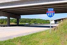
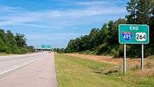
Though decommissioned, a portion of this freeway (from I-440 to I-540) was formerly designated I-495. As of April 2018, I-495 has not been removed from existing signage, but I-87, on separate sign assemblies, has been added near existing signs.[2]
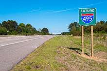
Beyond Rolesville Road, the remainder of the US 64 freeway is designated as Future I-87, as it is currently not at Interstate standards; needing wider travel lanes, wider shoulders, and more resilient barriers in the grass median. Additionally, the rest of the route to the Virginia border beyond Williamston, North Carolina is not built as a freeway, it would involve upgrading or building new roads parallel to existing US highways, including US 13, US 17 and US 158. Some of these upgrades are part of the DOT 10-year plan released in 2017, with upgrading of highways around Elizabeth City given a start date of 2023.[3]
The state of Virginia currently has no timetable to construct the northern portion of I-87 from the Virginia state line to Norfolk.
History
Interstate 495
| |
|---|---|
| Location | Raleigh–Knightdale, NC |
| Length | 4.09 mi[4][5] (6.58 km) |
| Existed | 2013–2017 |
A portion of I-87, originally named I-495, was first designated as an Interstate Highway on February 20, 2013, when the North Carolina Department of Transportation (NCDOT) submitted a request to AASHTO in order to establish Interstate 495 as a new auxiliary route of I-95. The proposed 44.99-mile (72.40 km) route would begin at I-440/US 64/US 64 Business in Raleigh and would end at I-95, in Rocky Mount, completely concurrent with US 64.[6]
On March 15, 2013, AASHTO received a modified request from NCDOT requesting the establishment of I-495 from I-440 to I-540 (4.09 mi or 6.58 km) and Future I-495 from I-540 to I-95 (40.90 mi or 65.82 km). It was approved, though needed an additional approval from FHWA.[5] On December 12, 2013, the proposed section was approved by the FHWA and was added to the interstate highway system. [7]
The freeway section, the part that was originally to be signed I-495 and continuing east to US 64 Business, was completed in 2006. From I-440 to Rolesville Road, the freeway was built to interstate standards; which is why the first official section of I-495 was able to connect between I-440 and I-540.[8] East of Rolesville Road, the freeway was built in sections, since 1975. This older section of freeway will eventually be upgraded to interstate standards; which include road rehabilitation and wider lanes and shoulders.
Renumbering
Long-term plans by the Raleigh-Durham area's Regional Transportation Alliance (RTA) called for extension of the interstate east of I-95 toward Elizabeth City, then northeastward to the Interstate 64/Interstate 464 interchange in the Norfolk-Virginia Beach (Hampton Roads) metropolitan area. The NCDOT proposed the Interstate 44 designation for the Raleigh–Norfolk High Priority Corridor consisting of portions of the I-495 and US 64 in North Carolina and US 17 in North Carolina and Virginia. The route would connect two of the largest US metro areas lacking an Interstate connection: the Research Triangle area around Raleigh and the Hampton Roads metro area around Norfolk.[9][10]
In November 2012, NCDOT requested the addition of the corridor to the Interstate Highway System through administrative options with the Federal Highway Administration as I-44.[11] Congressman G. K. Butterfield introduced legislation in June 2014 to add the corridor to the Interstate Highway System through Congressional authority.[12] An NCDOT policy paper said they were "seeking language in the reauthorization of surface transportation programs legislation to enhance the description of the Raleigh–Norfolk Corridor to include the route via Rocky Mount–Elizabeth City for clarity, and to designate the entire route from Raleigh to Norfolk as a future part of the Interstate system as I-44 or I-50."[9][10] Had the I-44 designation been approved, it would have been discontinuous with the current I-44, which runs between Wichita Falls, Texas, and St. Louis, Missouri.
On December 14, 2015, the proposed corridor was officially designated as a future interstate with the passage of the Fixing America's Surface Transportation Act (FAST Act).[13] Soon, several other route numbers were discussed and the RTA set their preference on two more-likely candidates: Interstate 56 if an east-west designation were chosen, or Interstate 89 if a north-south designation were chosen.[14] I-56 is not in use, while I-89 exists in Vermont and New Hampshire, far north of this corridor.[14] For the upcoming AASHTO Special Committee on U.S. Route Numbering, NCDOT proposed I-89 for this route.[15] On May 25, 2016, AASHTO instead approved I-87 as the number for the highway.[15][16] The new I-87 would be non-contiguous with the route with the same number in New York State.[17] The Interstate 87 designation pays tribute to several important dates in the history of both North Carolina and Virginia. The Roanoke Colony was founded in 1587; James Madison's Virginia Plan helped to develop U.S. Constitution in 1787; and North Carolina State University was created in 1887.[18]
On May 23, 2017, AASHTO approved the request by NCDOT to decommission existing I-495 and Future I-495; they are to be replaced with I-87 and Future I-87.[19] NCDOT began resigning the highway on September 5, 2017.[1] I-87 will continue east along US 64 to I-95 after the road is upgraded to interstate standards.[5][7]
Junction list
Current exit numbers are based on I-440 and US 64 mileage. The entire route is in Wake County.
| Location | mi | km | Exit | Destinations | Notes | |
|---|---|---|---|---|---|---|
| Raleigh | 0.0 | 0.0 | — | Continuation as I-40 / US 64 | ||
| 16 | Western end of I-440 concurrency | |||||
| 15 | Poole Road | |||||
| 419 | Future exit 3; eastern end of I-440 concurrency; western end of US 264 concurrency; eastbound signed as exit 14 | |||||
| 420 | New Hope Road | Future exit 4 | ||||
| Knightdale | 422 | Hodge Road | Future exit 6 | |||
| 423 | Future exit 7 | |||||
| | 425 | Smithfield Road | Future exit 9 | |||
| Wendell | 427 | Wendell Falls Parkway | Future exit 11 | |||
| 429 | Future exit 13 | |||||
| 430 | Rolesville Road – Rolesville | Future exit 14; northbound entrance and southbound exit | ||||
| — | Continuation as US 64 / US 264 | |||||
1.000 mi = 1.609 km; 1.000 km = 0.621 mi
| ||||||
Auxiliary routes
I-87 in North Carolina will eventually have one spur route, I-587, that overlays US 264 to Greenville, North Carolina.
See also


References
- 1 2 Stradling, Richard (September 6, 2017). "Have you driven on I-87 yet?". The News & Observer. Raleigh, NC. Retrieved September 6, 2017.
- ↑ Stradling, Richard. "Have you driven on Interstate 87 yet?". The News & Observer. Raleigh, NC. Retrieved September 19, 2017.
- ↑ Hawley, Jon. "I-87 work part of DOT's 10-year plan". Elizabeth City Daily Advance. Retrieved September 19, 2017.
- ↑ Google (December 14, 2013). "Interstate 495" (Map). Google Maps. Google. Retrieved December 14, 2013.
- 1 2 3 Lacy, J. Kevin (March 27, 2013). "An Application from the State Highway or Transportation Department of North Carolina" (PDF) (Letter). Letter to Frederick G. Wright. Raleigh: North Carolina Department of Transportation. Archived from the original (PDF) on October 19, 2013. Retrieved December 14, 2013 – via American Association of State Highway and Transportation Officials.
- ↑ North Carolina Department of Transportation (December 14, 2013). I-495 Route Change (2013-02-20) (PDF) (Map). c. 1:422,400. North Carolina Department of Transportation. Retrieved February 28, 2013.
- 1 2 North Carolina Department of Transportation (December 14, 2013). "North Carolina Gets a New Interstate, with the I-495 Designation near Raleigh" (Press release). North Carolina Department of Transportation. Retrieved December 12, 2013.
- ↑ North Carolina Department of Transportation (November 8, 2006). "US 64 Route Change (2006-11-08)" (PDF). North Carolina Department of Transportation. Retrieved December 14, 2013.
- 1 2 North Carolina Department of Transportation (June 11, 2014). "Future Interstate Designation: Raleigh, NC to Norfolk, VA" (PDF). North Carolina Department of Transportation. Archived from the original (PDF) on May 23, 2015. Retrieved September 4, 2014 – via Regional Transportation Alliance.
- 1 2 "Interstate 495 to Rocky Mount—Future I-44 to Hampton Roads". Raleigh, NC: Regional Transportation Alliance. December 14, 2013. Retrieved February 16, 2014.
- ↑ Gibson, Terry R. (November 27, 2012). "Designation of I-44" (PDF) (Letter). Letter to John F. Sullivan III. Raleigh: North Carolina Department of Transportation. Retrieved May 15, 2014.
- ↑ Tata, Anthony J. (June 11, 2014). "Route to Opportunity and Development Act (ROAD Act)" (PDF) (Letter). Letter to G.K. Butterfield. North Carolina Department of Transportation. Archived from the original (PDF) on May 23, 2015. Retrieved September 4, 2014.
- ↑ "H. R. 22—111" (PDF). Retrieved March 31, 2016.
- 1 2 Milazzo, Joe, II (December 31, 2015). "Raleigh-Norfolk: I-495, I-44, I-50, I-89, I-56 ... ?". Raleigh, NC: Regional Transportation Alliance. Retrieved February 1, 2016.
- 1 2 Special Committee on U.S. Route Numbering (May 24, 2016). "Special Committee on U.S. Route Numbering" (PDF) (Report). Washington, DC: American Association of State Highway and Transportation Officials. Retrieved May 26, 2016.
- ↑ Siceloff, Bruce (May 25, 2016). "Future Interstate Highway Names Approved". The News & Observer. Raleigh, NC. Retrieved May 25, 2016.
- ↑ Walker, Sam (May 26, 2016). "Future interstate from Chesapeake to Raleigh will be I-87". The Outer Banks Voice. Retrieved August 14, 2017.
- ↑ "North Carolina Gets Designations for 2 More Interstates". Raleigh, NC: WRAL-TV. May 26, 2016. Retrieved December 2, 2016.
- ↑ Special Committee on U.S. Route Numbering (May 23, 2017). "Special Committee on U.S. Route Numbering" (PDF) (Report). Washington, DC: American Association of State Highway and Transportation Officials. p. 5. Retrieved June 9, 2017.
External links
| Wikimedia Commons has media related to |
Route map:
| Signed | |
|---|---|
| Unsigned | |
| Lists | |
| Other | |
Major Interstates highlighted | |
| ||