North Carolina Highway 67
| ||||
|---|---|---|---|---|
 | ||||
| Route information | ||||
| Maintained by NCDOT | ||||
| Length | 40.9 mi[1] (65.8 km) | |||
| Existed | 1930 – present | |||
| Major junctions | ||||
| West end |
| |||
| East end |
| |||
| Location | ||||
| Counties | Yadkin, Forsyth | |||
| Highway system | ||||
| ||||
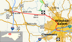
North Carolina Highway 67 (NC 67) is a 40.9-mile-long (65.8 km) primary state highway in the U.S. state of North Carolina. It serves mostly the northern area of Yadkin County, connecting the towns of Jonesville, Boonville and East Bend, along with the city of Winston-Salem in Forsyth County.
Route description
The western terminus is U.S. Route 21 Business (US 21 Bus.) in Jonesville. From this point in Yadkin County, the route travels in an easterly direction over Interstate 77 (I-77), through Boonville and East Bend before crossing the Yadkin River into Forsyth County.
After crossing the county line, NC 67 turns to head in a southeasterly direction through part of Tobaccoville, and near Bethania and Pfafftown on its way into Winston-Salem. Once within Winston-Salem's city limits, the route bears the street name Reynolda Road on its straight southeasterly journey toward downtown. Arriving at the Wake Forest University campus, NC 67 bears right onto a short 1⁄4-mile-long (0.40 km) road known as Wake Forest Road, which connects to Silas Creek Parkway, a four-lane boulevard. NC 67 eastbound shares Silas Creek Parkway southbound around Winston-Salem's west side, past Hanes Mall, to end at NC 150 (Peters Creek Parkway) in the city's south side.
History
The Silas Creek Parkway was constructed in 1960 to serve as a loop road around Winston-Salem, running between the recently-built Forsyth Memorial Hospital. It was opened on November 4, 1961, and spurred suburban development in the outskirts of Winston-Salem, which necessitated a widening to four lanes two years later.[2] The construction of the extended parkway was controversial with Wake Forest College students, who staged a protest over its siting near the campus.[3]
Junction list
| County | Location | mi[1] | km | Destinations | Notes |
|---|---|---|---|---|---|
| Yadkin | Jonesville | 0.0 | 0.0 | ||
| 1.4– 1.6 | 2.3– 2.6 | Exit 82 (I-77) | |||
| Boonville | 7.8 | 12.6 | |||
| Forsyth | Winston-Salem | 35.3– 35.6 | 56.8– 57.3 | Robinhood Road | Interchange |
| 36.8– 36.9 | 59.2– 59.4 | Country Club Road | Interchange | ||
| 37.4– 37.7 | 60.2– 60.7 | Exit 2A (I-40 Bus.) | |||
| 37.9– 38.1 | 61.0– 61.3 | Interchange | |||
| 38.8– 39.0 | 62.4– 62.8 | Bolton Street | Interchange | ||
| 40.9 | 65.8 | ||||
| 1.000 mi = 1.609 km; 1.000 km = 0.621 mi | |||||
References
- 1 2 Google (May 5, 2015). "North Carolina Highway 67" (Map). Google Maps. Google. Retrieved May 5, 2015.
- ↑ "Northwest Almanac: Early days of Silas Creek Parkway". Winston-Salem Journal. October 30, 2017. Retrieved August 13, 2018.
- ↑ "Students Hit Road Location". Statesville Record & Landmark. November 17, 1961. p. 3. Retrieved August 13, 2018 – via Newspapers.com.
