Benton, Kentucky
| Benton, Kentucky | |
|---|---|
| City | |
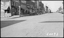 Benton in 1939 | |
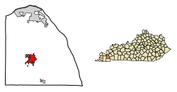 Location of Benton in Marshall County, Kentucky. | |
| Coordinates: 36°51′19″N 88°21′15″W / 36.85528°N 88.35417°WCoordinates: 36°51′19″N 88°21′15″W / 36.85528°N 88.35417°W | |
| Country | United States |
| State | Kentucky |
| County | Marshall |
| Area | |
| • Total | 4.32 sq mi (11.18 km2) |
| • Land | 4.26 sq mi (11.04 km2) |
| • Water | 0.05 sq mi (0.14 km2) |
| Elevation | 427 ft (130 m) |
| Population (2010) | |
| • Total | 4,349 |
| • Estimate (2016)[1] | 4,531 |
| • Density | 1,007.4/sq mi (388.96/km2) |
| Time zone | UTC-6 (Central (CST)) |
| • Summer (DST) | UTC-5 (CDT) |
| ZIP code | 42025 |
| Area code(s) | 270 & 364 |
| FIPS code | 21-05824 |
| GNIS feature ID | 0486888 |
| Website | www.cityofbenton.org |
Benton is a U.S. home rule-class city in Marshall County, Kentucky. The current mayor of this city is Rita Dotson. The population was 4,349 at the 2010 census. It is the county seat of Marshall County.[2] Benton was named for Thomas Hart Benton, a senator from Missouri.[3]
Shape note singers gather annually at Benton on the fourth Sunday in May to sing from a tunebook called The Southern Harmony. This event, organized in 1884 and called The Big Singing or Big Singing Day, is considered by many to be the oldest indigenous musical tradition in the United States. Benton is also known for an annual festival called "Tater Day", which attracts residents from all over the Jackson Purchase and involves games, deep fried food, and a parade.
Geography
According to the United States Census Bureau, the city has a total area of 3.9 square miles (10 km2), all land.
Education
Benton is part of the Marshall County School District. There are 11 schools in the district, not including the technical school that is incorporated with Marshall County High School, the district's only secondary educational institution.
For the 2011 to 2012 school year, there were approximately 4,838 students enrolled.[4]
On January 23, 2018, a shooting occurred at Marshall County High School with 19 injuries and 2 fatalities. Suspect reported in custody.[5][6]
Demographics
| Historical population | |||
|---|---|---|---|
| Census | Pop. | %± | |
| 1860 | 165 | — | |
| 1880 | 277 | — | |
| 1890 | 344 | 24.2% | |
| 1900 | 664 | 93.0% | |
| 1910 | 824 | 24.1% | |
| 1920 | 897 | 8.9% | |
| 1930 | 1,021 | 13.8% | |
| 1940 | 1,906 | 86.7% | |
| 1950 | 1,980 | 3.9% | |
| 1960 | 3,074 | 55.3% | |
| 1970 | 3,652 | 18.8% | |
| 1980 | 3,700 | 1.3% | |
| 1990 | 3,899 | 5.4% | |
| 2000 | 4,197 | 7.6% | |
| 2010 | 4,349 | 3.6% | |
| Est. 2016 | 4,531 | [1] | 4.2% |
| U.S. Decennial Census[7] | |||
As of the 2010 Census,[8] there were 4,349 people, 1,809 households, and 1,154 families residing in the city. The population density was 1,007.4 people per square mile (389.0/km²). There were 2,032 housing units at an average density of 470.7 per square mile (181.73/km²). The racial makeup of the city was 97.4% White (96.4% non-Hispanic), 0.4% African American, 0.1% Native American and Alaska Native, 0.6% Asian, 0.6% from other races, and 0.9% from two or more races. Hispanics or Latinos of any race were 1.8% of the population.
There were 1,809 households out of which 27.2% had children under the age of 18 living with them, 48.5% were married couples living together, 11.4% had a female householder with no husband present, 3.9% had a male householder with no wife present, and 36.2% were non-families. 33.2% of all households were made up of individuals and 17.1% had someone living alone who was 65 years of age or older. The average household size was 2.26 and the average family size was 2.84.
The age distribution was 21.5% under 18, 7.7% from 18 to 24, 26.1% from 25 to 44, 23.4% from 45 to 64, and 21.4% who were 65 or older. The median age was 40.5 years. For every 100 females, there were 89.7 males. For every 100 females age 18 and over, there were 86.7 males.
Based on 2008–2012 estimates from the American Community Survey, the median income for a household in the city was $42,342, and the median income for a family was $62,500. Among full-time workers, males had a median income of $47,895 versus $29,272 for females. The per capita income for the city was $21,959. About 4.5% of families and 8.4% of the population were below the poverty line, including 5.3% of those under age 18 and 10.7% of those age 65 or over.
References
- 1 2 "Population and Housing Unit Estimates". Retrieved June 9, 2017.
- ↑ "Find a County". National Association of Counties. Archived from the original on 2011-05-31. Retrieved 2011-06-07.
- ↑ Collins, Lewis (1877). History of Kentucky. p. 543.
- ↑ "Marshall County School District". Education.com. Retrieved 2012-06-15.
- ↑ Joyce, Kathleen (23 January 2018). "Kentucky school shooting leaves at least one dead and multiple wounded, officials say". Fox News. Retrieved 23 January 2018.
- ↑ "NBC news school shooting update".
- ↑ "Census of Population and Housing". Census.gov. Archived from the original on May 12, 2015. Retrieved June 4, 2015.
- ↑ "American FactFinder". United States Census Bureau. Archived from the original on 2013-09-11. Retrieved 2011-05-14.
External links

Municipalities and communities of Marshall County, Kentucky, United States | ||
|---|---|---|
| Cities | 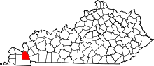 | |
| CDP | ||
| Other unincorporated communities | ||
| Ghost town | ||