Brownsville, Kentucky
| Brownsville, Kentucky | |
|---|---|
| City | |
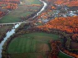 Aerial photograph of Brownsville | |
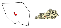 Location of Brownsville in Edmonson County, Kentucky. | |
| Coordinates: 37°11′28″N 86°15′40″W / 37.19111°N 86.26111°WCoordinates: 37°11′28″N 86°15′40″W / 37.19111°N 86.26111°W | |
| Country | United States |
| State | Kentucky |
| County | Edmonson |
| Established | 1826[1] |
| Government | |
| Area | |
| • Total | 2.62 sq mi (6.78 km2) |
| • Land | 2.61 sq mi (6.77 km2) |
| • Water | 0.008 sq mi (0.02 km2) |
| Elevation | 545 ft (166 m) |
| Population (2010) | |
| • Total | 836 |
| • Estimate (2016)[2] | 832 |
| • Density | 320/sq mi (123.6/km2) |
| Time zone | UTC-6 (Central (CST)) |
| • Summer (DST) | UTC-5 (CDT) |
| ZIP code | 42210[3] |
| Area code(s) | 270 & 364 |
| FIPS code | 21-10324 |
| GNIS feature ID | 0488045 |
Brownsville is a home rule-class city in Edmonson County, Kentucky, in the United States. It is the county seat.[4] The population was 836 at the time of the 2010 census,[5] down from 921 at the 2000 census. It is included in the Bowling Green metropolitan area.[6] It is just outside Mammoth Cave National Park.[7]
Geography
Brownsville is located near the center of Edmonson County at 37°11′28″N 86°15′40″W / 37.191169°N 86.261098°W.[8] The city limits border the western edge of Mammoth Cave National Park, with access to Houchin Ferry Campground.
State Routes 70 and 259 pass through the city together as Main Street. KY 70 leads east 20 miles (32 km) to Cave City and west 27 miles (43 km) to U.S. Route 231 at Aberdeen, while KY 259 leads southeast 12 miles (19 km) to U.S. Route 31W and north 25 miles (40 km) to Leitchfield.
According to the United States Census Bureau, Brownsville has a total area of 2.6 square miles (6.8 km2), of which 0.01 square miles (0.02 km2), or 0.26%, is water.[5] The city is located on the Green River, a tributary of the Ohio River.[1]
Demographics
| Historical population | |||
|---|---|---|---|
| Census | Pop. | %± | |
| 1830 | 229 | — | |
| 1840 | 112 | −51.1% | |
| 1880 | 116 | — | |
| 1890 | 113 | −2.6% | |
| 1900 | 234 | 107.1% | |
| 1910 | 313 | 33.8% | |
| 1920 | 294 | −6.1% | |
| 1930 | 359 | 22.1% | |
| 1940 | 451 | 25.6% | |
| 1950 | 447 | −0.9% | |
| 1960 | 473 | 5.8% | |
| 1970 | 542 | 14.6% | |
| 1980 | 674 | 24.4% | |
| 1990 | 897 | 33.1% | |
| 2000 | 921 | 2.7% | |
| 2010 | 836 | −9.2% | |
| Est. 2016 | 832 | [2] | −0.5% |
| U.S. Decennial Census[9] | |||
As of the census of 2000, there were 921 people, 387 households, and 229 families residing in the city. The population density was 581.0 people per square mile (223.6/km²). There were 421 housing units at an average density of 265.6 per square mile (102.2/km²). The racial makeup of the city was 98.37% White, 0.11% African American, 0.43% Native American, 0.11% Asian, 0.11% from other races, and 0.87% from two or more races. Hispanic or Latino of any race were 0.76% of the population.
There were 387 households out of which 26.4% had children under the age of 18 living with them, 40.6% were married couples living together, 16.8% had a female householder with no husband present, and 40.6% were non-families. 37.5% of all households were made up of individuals and 15.8% had someone living alone who was 65 years of age or older. The average household size was 2.15 and the average family size was 2.81.
In the city, the population was spread out with 20.3% under the age of 18, 8.6% from 18 to 24, 22.8% from 25 to 44, 24.4% from 45 to 64, and 23.9% who were 65 years of age or older. The median age was 43 years. For every 100 females, there were 72.5 males. For every 100 females age 18 and over, there were 71.1 males.
The median income for a household in the city was $15,370, and the median income for a family was $21,250. Males had a median income of $26,125 versus $14,583 for females. The per capita income for the city was $15,711. About 30.8% of families and 32.6% of the population were below the poverty line, including 45.2% of those under age 18 and 24.5% of those age 65 or over.
Plain community
There is a Plain, horse and buggy community with about 40 to 50 people in Peace Valley, Brownsville. It is closely affiliated with Caneyville.
   They live off of the electronic grid with one exception, one cord that runs to a phone booth, which has two home phones in it and is centered in the community, specifically not right beside any house. The basic idea is that they do not want to incorporate the phone into their every day life to a point where it is a very major part of it. If the phone is not easily accessible then it is only used when necessary, which they consider is business. Besides business and necessary family or friend contacts every once in a while it is limited to just business. One must remember that the idea with the community is that the family is there so there's no need to call other places. They would rather focus on their every day relationships in the community and with the nearby neighbors that the community affects.
Electronic Standard: Just because they live off of the grid doesn't mean that they don't have some amount of electricity though. The few exceptions to the general of independence of technology would be welders,headlights, and one way that Brownsville differs from Caneyville is that they will not use big LED lights like Caneyville uses, such as Dewalt lights, electric fencing, charging an electronic scale the phone and a very simple cash register,bike lights, which will be expounded upon later, and water pumps, for they pump their own water, with the exception of when they have to use city water for things such as certified cooking kitchens.
  Just because of their reservation with electricity doesn't mean that they don' have some source of energy for things such as steel fabrication, casting iron, wood working, etc., they use older methods of capturing energy. Their most commonly used method is Steam engine, which was put into use through the 17 hundreds, 18 hundreds, and early 19 hundreds. That is limited mostly to their shops though, and farming being their largest occupation they use horses, not just to pull the plows, hay tetters, cultivaters and general farm equipment but also their buggies and they will harness them and put them on treadmills or in circle mills.
  Inner community order is managed by a spiritual leader they term as Bishop who has underneath him, ministers,which help minister the word and minister as they see fit for God, and a deacon, whos purpose is controversial but at least is to help the sick and take care of alot of the small details of community life.
  Dress: the women wear a simple dress consisting of the main part, an apron that adds as another layer to take away from the definition of bodily shape, and a head covering that reveals only a little hair at the front. The women will sew their own clothes and most of the families clothes. That varies from house to house, some women sewing all of the clothes, save underwear and socks, some buying from those who sew plain people clothes commercially.
  The men dress in button down shirts that are long sleeved and collarless, broadfalls, which are like jeans except they can be made out of any fabric and at the front instead of having a zipper has buttons going from side to side, that hold up a flap. The finishing touch is the suspenders, which quite literally are supposed to suspend their pants.
  Dogma towards the world: They feel bad for the people living in american society because they feel like they are living a sinful life that will lead to judgement from the key figure in their lifestyle, God. They feel alot of love however for them and hope that by being a good witness of God's grace can lead some to the light.
  Transport: As was stated earlier, they use horses primarily, and as should be said they own no vehicles. They will,however, hire a driver,as the call their transporters, to take them where their buggies cannot, and bikes. They use bikes for transportation around their community and will go on long several hundred mile trips on them.
Education
Brownsville is served by the Edmonson County Schools.[10] Schools in the district located in Brownsville are:
References
- 1 2 Kentucky, University of. "Brownsville, Kentucky". Gazetteer, Kentucky Atlas and. Retrieved 2010-04-15.
- 1 2 "Population and Housing Unit Estimates". Retrieved June 9, 2017.
- ↑ Inc., Advameg (2010). "Brownsville, Kentucky (KY 42210) profile". Retrieved 2010-04-15.
- ↑ "Find a County". National Association of Counties. Archived from the original on 2011-05-31. Retrieved 2011-06-07.
- 1 2 "Geographic Identifiers: 2010 Demographic Profile Data (G001): Brownsville city, Kentucky". American Factfinder. U.S. Census Bureau. Retrieved January 29, 2016.
- ↑ Management and Budget, Office of (2008-11-20). "OMB BULLETIN NO. 09-01" (PDF). the President, Executive Office of. Retrieved 2010-04-15.
- ↑ Service, National Park. "Mammoth Cave National Park Map" (PDF). Retrieved 2010-04-15.
- ↑ "US Gazetteer files: 2010, 2000, and 1990". United States Census Bureau. 2011-02-12. Retrieved 2011-04-23.
- ↑ "Census of Population and Housing". Census.gov. Archived from the original on May 12, 2015. Retrieved June 4, 2015.
- ↑ Education, Kentucky Department of (2009-10-29). "County & Independent School Districts" (PDF). Kentucky, Commonwealth of. Archived from the original (PDF) on 2010-01-10. Retrieved 2010-04-15.
- ↑ Edmonson County High Schools. "Edmonson County High School". Retrieved 2010-04-15.
- 1 2 Edmonson County High School. "Edmonson County High School". Archived from the original on 2010-04-19. Retrieved 2010-04-15.
- ↑ Edmonson County Middle School (2010-03-29). "ECMS Home Page". Retrieved 2010-04-15.
- ↑ School-Based Decision-Making Council, Edmonson County Middle School (2010-02-05). "ECMS SBDM Council". Retrieved 2010-04-15.
- ↑ 5th/6th Center, Edmonson County (2009-08-19). "Welcome to the Frontpage". Retrieved 2010-04-15.
- ↑ 5th/6th Center, Edmonson County (2009-09-23). "Teachers". Archived from the original on 2010-04-18. Retrieved 2010-04-15.
External links
- Brownsville at the U.S. Geographic Names Information System
| Wikivoyage has a travel guide for Brownsville, Kentucky. |
Municipalities and communities of Edmonson County, Kentucky, United States | ||
|---|---|---|
| City | 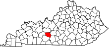 | |
| Unincorporated communities | ||
| Ghost town | ||
| Footnotes | ‡This populated place also has portions in an adjacent county or counties | |
| Principal city | _Metro.png) | |
|---|---|---|
| Other municipalities | ||
| Counties | ||
