New Castle, Kentucky
| New Castle, Kentucky | |
|---|---|
| City | |
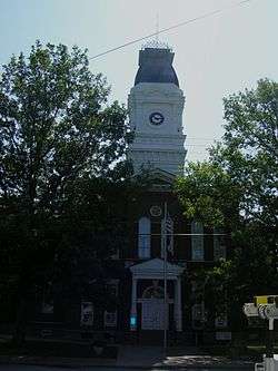 Henry County courthouse in New Castle, Kentucky | |
 Location of New Castle in Henry County, Kentucky. | |
| Coordinates: 38°26′1″N 85°10′10″W / 38.43361°N 85.16944°WCoordinates: 38°26′1″N 85°10′10″W / 38.43361°N 85.16944°W | |
| Country | United States |
| State | Kentucky |
| County | Henry |
| Established | 1817[1] |
| Incorporated | 1851[1] |
| Government | |
| • Mayor | Denny Benham |
| Area | |
| • Total | 0.41 sq mi (1.07 km2) |
| • Land | 0.41 sq mi (1.06 km2) |
| • Water | 0.004 sq mi (0.01 km2) |
| Elevation | 833 ft (254 m) |
| Population (2010) | |
| • Total | 912 |
| • Estimate (2016)[2] | 937 |
| • Density | 2,223/sq mi (858.2/km2) |
| Time zone | UTC-5 (Eastern (EST)) |
| • Summer (DST) | UTC-4 (EDT) |
| ZIP code | 40050 |
| Area code(s) | 502 |
| FIPS code | 21-55596 |
| GNIS feature ID | 0499296 |
| Website |
www |
New Castle is a home rule-class city in Henry County, Kentucky, in the United States. It is the seat of its county.[3] As of the 2010 census the population was 912.[4]
History
New Castle was incorporated in 1817.[5]
Geography
New Castle is located southwest of the center of Henry County at 38°26′1″N 85°10′10″W / 38.43361°N 85.16944°W (38.433645, -85.169345).[6] U.S. Route 421 follows Main Street and leads north 7 miles (11 km) to Campbellsburg and southeast 29 miles (47 km) to Frankfort. Louisville is 38 miles (61 km) to the southwest via Kentucky Route 146 and Interstate 71.
According to the United States Census Bureau, New Castle has a total area of 0.42 square miles (1.1 km2), of which 0.004 square miles (0.01 km2), or 1.04%, is water.[4]
Demographics
| Historical population | |||
|---|---|---|---|
| Census | Pop. | %± | |
| 1830 | 538 | — | |
| 1840 | 528 | −1.9% | |
| 1860 | 519 | — | |
| 1870 | 670 | 29.1% | |
| 1880 | 500 | −25.4% | |
| 1890 | 485 | −3.0% | |
| 1900 | 462 | −4.7% | |
| 1910 | 468 | 1.3% | |
| 1920 | 397 | −15.2% | |
| 1930 | 447 | 12.6% | |
| 1940 | 487 | 8.9% | |
| 1950 | 631 | 29.6% | |
| 1960 | 699 | 10.8% | |
| 1970 | 755 | 8.0% | |
| 1980 | 832 | 10.2% | |
| 1990 | 893 | 7.3% | |
| 2000 | 919 | 2.9% | |
| 2010 | 912 | −0.8% | |
| Est. 2016 | 937 | [2] | 2.7% |
| U.S. Decennial Census[7] | |||
At the census[8] of 2000, there were 919 people, 382 households, and 239 families residing in the city. The population density was 2,067.0 people per square mile (806.4/km²). There were 409 housing units at an average density of 919.9 per square mile (358.9/km²). The racial makeup of the city was 92.60% White, 5.77% Black or African American, 0.98% from other races, and 0.65% from two or more races. Hispanic or Latino of any race were 1.52% of the population.
There were 382 households out of which 29.8% had children under the age of 18 living with them, 41.6% were married couples living together, 17.5% had a female householder with no husband present, and 37.2% were non-families. 33.2% of all households were made up of individuals and 17.3% had someone living alone who was 65 years of age or older. The average household size was 2.25 and the average family size was 2.86.
In the city, the population was spread out with 22.7% under the age of 18, 7.9% from 18 to 24, 25.2% from 25 to 44, 25.0% from 45 to 64, and 19.0% who were 65 years of age or older. The median age was 40 years. For every 100 females, there were 77.8 males. For every 100 females age 18 and over, there were 73.2 males.
The median income for a household in the city was $24,931, and the median income for a family was $34,550. Males had a median income of $27,813 versus $19,615 for females. The per capita income for the city was $12,626. About 26.8% of families and 27.3% of the population were below the poverty line, including 34.4% of those under age 18 and 20.9% of those age 65 or over.
Culture and recreation
The Samuel Hieatt House, built in 1850, was listed on the National Register of Historic Places in 1982.[9]
References
- 1 2 Commonwealth of Kentucky. Office of the Secretary of State. Land Office. "New Castle, Kentucky". Accessed 15 September 2013.
- 1 2 "Population and Housing Unit Estimates". Retrieved June 9, 2017.
- ↑ "Find a County". National Association of Counties. Retrieved 2011-06-07.
- 1 2 "Geographic Identifiers: 2010 Demographic Profile Data (G001): New Castle city, Kentucky". American Factfinder. U.S. Census Bureau. Retrieved July 5, 2017.
- ↑ Collins, Lewis (1877). History of Kentucky. p. 338.
- ↑ "US Gazetteer files: 2010, 2000, and 1990". United States Census Bureau. 2011-02-12. Retrieved 2011-04-23.
- ↑ "Census of Population and Housing". Census.gov. Retrieved June 4, 2015.
- ↑ "American FactFinder". United States Census Bureau. Retrieved 2008-01-31.
- ↑ "NRHP nomination form". National Park Service. Retrieved 19 October 2012.
External links
Municipalities and communities of Henry County, Kentucky, United States | ||
|---|---|---|
| Cities | 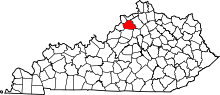 | |
| Unincorporated communities | ||
| Footnotes | ‡This populated place also has portions in an adjacent county or counties | |