Owingsville, Kentucky
| Owingsville, Kentucky | |
|---|---|
| City | |
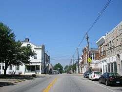 Downtown Owingsville | |
 Location of Owingsville in Bath County, Kentucky. | |
 Owingsville Location of Owingsville in Bath County, Kentucky. | |
| Coordinates: 38°8′34″N 83°45′58″W / 38.14278°N 83.76611°WCoordinates: 38°8′34″N 83°45′58″W / 38.14278°N 83.76611°W | |
| Country | United States |
| State | Kentucky |
| County | Bath |
| Established | c. 1811[1] |
| Incorporated | 1829[2] |
| Named for | Thomas Dye Owings[2] |
| Government | |
| • Type | Mayor and City Council |
| • Mayor | Gary M. Hunt |
| Area | |
| • Total | 2.41 sq mi (6.24 km2) |
| • Land | 2.39 sq mi (6.19 km2) |
| • Water | 0.02 sq mi (0.06 km2) |
| Elevation | 1,004 ft (306 m) |
| Population (2010) | |
| • Total | 1,530 |
| • Estimate (2016)[3] | 1,592 |
| • Density | 641/sq mi (247.3/km2) |
| Time zone | UTC-5 (Eastern (EST)) |
| • Summer (DST) | UTC-4 (EDT) |
| ZIP code | 40360 |
| Area code(s) | 606 |
| FIPS code | 21-58710 |
| GNIS feature ID | 0507358 |
Owingsville is a home rule-class city[4] in Bath County, Kentucky, in the United States. The population was 1,530 during the year 2010 U.S. Census.[5] It is the county seat[6] and is located roughly at the county's center, at the junction of US 60 and Kentucky 36. It is part of the Mount Sterling micropolitan area.
History
In 1795, Colonel Thomas Dye Owings was sent from Maryland to Kentucky by his father to operate some of the first iron furnaces in the region. Within fifteen years, Owings had amassed a good deal of wealth and land. Along with Colonel Richard H. Menefee, Owings would found the community that took his name, Owingsville.
Owings and Menefee each owned significant parcels of land in what would become Owingsville. To select whose name the community would take, the two men wagered that the man who built the finer home the quickest would be the namesake of the town. For the sum of $60,000, Owings won the contest. Owingsville was then founded in 1811.
Owingsville was the birthplace of Civil War general John Bell Hood, Indiana governors Henry S. Lane and Claude Matthews, and Tennessee governor Alvin Hawkins.
Every year the county celebrates with the May Day Pageant, where high school seniors can compete for the title of "Miss Bath County". The pageant tradition started in 1954 and is a beloved tradition of the community. The week consists of various activities including a cake auction and a parade.
The town's mascot is the Wildcats with school colors being red and white.
Every year the town has their annual "March Against Drugs" march, in which student from the three schools located in town march from the school, uptown, and back to the school for an assembly.
Geography
Owingsville is located at 38°8′34″N 83°45′58″W / 38.14278°N 83.76611°W (38.142694, -83.766135).[7] According to the United States Census Bureau, the city has a total area of 2.4 square miles (6.2 km2), of which 0.023 square miles (0.06 km2), or 0.93%, is water.[5]
Demographics
| Historical population | |||
|---|---|---|---|
| Census | Pop. | %± | |
| 1830 | 241 | — | |
| 1840 | 251 | 4.1% | |
| 1860 | 480 | — | |
| 1870 | 550 | 14.6% | |
| 1880 | 773 | 40.5% | |
| 1890 | 763 | −1.3% | |
| 1900 | 958 | 25.6% | |
| 1910 | 942 | −1.7% | |
| 1920 | 781 | −17.1% | |
| 1930 | 933 | 19.5% | |
| 1940 | 948 | 1.6% | |
| 1950 | 929 | −2.0% | |
| 1960 | 1,040 | 11.9% | |
| 1970 | 1,381 | 32.8% | |
| 1980 | 1,419 | 2.8% | |
| 1990 | 1,491 | 5.1% | |
| 2000 | 1,488 | −0.2% | |
| 2010 | 1,530 | 2.8% | |
| Est. 2016 | 1,592 | [3] | 4.1% |
| U.S. Decennial Census[8] | |||
In the census[9] of 2000, there were 1,488 people, 659 households, and 419 families in the city. The population density is 683.7 people per square mile (263.5/km²). There are 720 housing units at an average density of 330.8 per square mile (127.5/km²). The racial makeup of the city is 95.23% White, 3.97% African American, 0.13% Native American, and 0.67% from two or more races. 0.67% of the population are Hispanic or Latino of any race.
There are 659 households out of which 28.5% have children under the age of 18 living with them, 41.7% are married couples living together, 17.9% have a female householder with no husband present, and 36.4% are non-families. 34.4% of all households are made up of individuals and 22.5% have someone living alone who is 65 years of age or older. The average household size is 2.17 and the average family size is 2.73.
In the city, the population is spread out with 21.2% under the age of 18, 9.3% from 18 to 24, 22.7% from 25 to 44, 21.0% from 45 to 64, and 25.7% who are 65 years of age or older. The median age is 43 years. For every 100 females, there are 78.6 males. For every 100 females age 18 and over, there are 71.2 males.
The median income for a household in the city is $21,897, and the median income for a family is $34,167. Males have a median income of $30,893 versus $20,208 for females. The per capita income for the city is $18,156. 26.6% of the population and 23.3% of families are below the poverty line. Out of the total population, 41.1% of those under the age of 18 and 18.7% of those 65 and older are living below the poverty line.
Notable natives
- George Nicholas Bascom, U.S. Army officer whose arrest of Chief Cochise started the Apache Wars
- John Bell Hood, Confederate general
- Andrew Trumbo (1797–1871), United States Representative from Kentucky.
- Tyrone S. Johnson, Famous poet from the early 1900's.
References
- ↑ Commonwealth of Kentucky. Office of the Secretary of State. Land Office. "Owingsville, Kentucky". Accessed 19 September 2013.
- 1 2 Kentucky Atlas and Gazetteer. Owingsville, Kentucky. Accessed 19 May 2017
- 1 2 "Population and Housing Unit Estimates". Retrieved June 9, 2017.
- ↑ "Summary and Reference Guide to House Bill 331 City Classification Reform" (PDF). Kentucky League of Cities. Retrieved December 30, 2014.
- 1 2 "Geographic Identifiers: 2010 Demographic Profile Data (G001): Owingsville city, Kentucky". U.S. Census Bureau, American Factfinder. Retrieved November 19, 2013.
- ↑ "Find a County". National Association of Counties. Retrieved 2011-06-07.
- ↑ "US Gazetteer files: 2010, 2000, and 1990". United States Census Bureau. 2011-02-12. Retrieved 2011-04-23.
- ↑ "Census of Population and Housing". Census.gov. Retrieved June 4, 2015.
- ↑ "American FactFinder". United States Census Bureau. Retrieved 2008-01-31.
External links
Municipalities and communities of Bath County, Kentucky, United States | ||
|---|---|---|
| Cities | 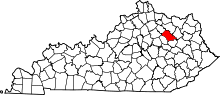 | |
| Unincorporated communities | ||