| [3] |
Name on the Register[4] |
Image |
Date listed[5] |
Location |
City or town |
Description |
|---|
| 1 |
Ardmore Historic District |
|
August 25, 2004
(#04000904) |
Roughly bounded by Knollwood, Queen, Duke, and Ardsley Sts.
36°05′03″N 80°16′29″W / 36.084167°N 80.274722°W / 36.084167; -80.274722 (Ardmore Historic District) |
Winston-Salem |
|
| 2 |
Arista Cotton Mill Complex |
|
August 18, 1977
(#77000999) |
200 Brookstown Ave.
36°05′24″N 80°14′46″W / 36.09°N 80.246111°W / 36.09; -80.246111 (Arista Cotton Mill Complex) |
Winston-Salem |
|
| 3 |
Atkins High School (former) |
|
December 30, 1999
(#99001618) |
1215 N. Cameron Ave.
36°06′39″N 80°13′17″W / 36.110833°N 80.221389°W / 36.110833; -80.221389 (Atkins High School (former)) |
Winston-Salem |
|
| 4 |
S. G. Atkins House |
|
July 22, 1979
(#79001704) |
346 Atkins St.
36°05′32″N 80°13′45″W / 36.092222°N 80.229167°W / 36.092222; -80.229167 (S. G. Atkins House) |
Winston-Salem |
|
| 5 |
Agnew Hunter Bahnson House |
|
April 12, 2001
(#01000375) |
Junction of W. Fifth and Spring Sts.
36°05′54″N 80°15′12″W / 36.098333°N 80.253333°W / 36.098333; -80.253333 (Agnew Hunter Bahnson House) |
Winston-Salem |
|
| 6 |
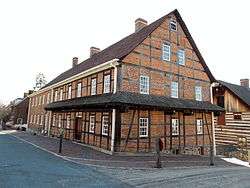
Bethabara Historic District |
|
November 15, 1978
(#78001948) |
North of Winston-Salem on NC 67
36°09′16″N 80°17′55″W / 36.154444°N 80.298611°W / 36.154444; -80.298611 (Bethabara Historic District) |
Winston-Salem |
|
| 7 |
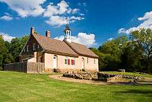
Bethabara Moravian Church |
|
September 28, 1971
(#71000586) |
2147 Bethabara Rd.
36°09′12″N 80°18′01″W / 36.153333°N 80.300278°W / 36.153333; -80.300278 (Bethabara Moravian Church) |
Winston-Salem |
|
| 8 |
Bethania Historic District |
|
May 3, 1976
(#76001321) |
North of Winston-Salem on NC 65, SR 1611, 1628, and 1688; also roughly the area outside the original district west and north along Muddy Creek, south to Reynolda Rd., and east along Walker Rd.
36°10′51″N 80°20′16″W / 36.180833°N 80.337778°W / 36.180833; -80.337778 (Bethania Historic District) |
Winston-Salem |
Second set of boundaries represents a boundary increase of March 25, 1991 |
| 9 |
George Black House and Brickyard |
|
January 28, 2000
(#99001683) |
111 Dellabrook Rd.
36°06′48″N 80°12′35″W / 36.113333°N 80.209722°W / 36.113333; -80.209722 (George Black House and Brickyard) |
Winston-Salem |
|
| 10 |
William Allen Blair House |
|
April 25, 1985
(#85000876) |
210 S. Cherry St.
36°05′31″N 80°14′48″W / 36.091944°N 80.246667°W / 36.091944; -80.246667 (William Allen Blair House) |
Winston-Salem |
|
| 11 |
Joseph Franklin Bland House |
|
August 21, 1984
(#84002265) |
1809 Virginia Rd.
36°06′20″N 80°16′13″W / 36.105556°N 80.270278°W / 36.105556; -80.270278 (Joseph Franklin Bland House) |
Winston-Salem |
|
| 12 |
Brickenstein-Leinbach House |
|
September 3, 1991
(#91001169) |
426 Old Salem Rd.
36°05′25″N 80°14′40″W / 36.090278°N 80.244444°W / 36.090278; -80.244444 (Brickenstein-Leinbach House) |
Winston-Salem |
|
| 13 |
W.C. Brown Apartment Building |
|
June 26, 1998
(#98000725) |
311-317 E. 7th St.
36°06′09″N 80°14′28″W / 36.1025°N 80.241111°W / 36.1025; -80.241111 (W.C. Brown Apartment Building) |
Winston-Salem |
|
| 14 |
Centerville Historic District |
|
May 8, 2008
(#08000379) |
Roughly bounded by Waughtown, Vargrave, Haled & Chapel Sts.
36°04′23″N 80°13′58″W / 36.073056°N 80.232778°W / 36.073056; -80.232778 (Centerville Historic District) |
Winston-Salem |
|
| 15 |
Chatham Manufacturing Company-Western Electric Company |
|
August 4, 2011
(#11000509) |
750 & 800 Chatham Rd.
36°06′17″N 80°15′18″W / 36.104722°N 80.255°W / 36.104722; -80.255 (Chatham Manufacturing Company-Western Electric Company) |
Winston-Salem |
|
| 16 |
Thurmond and Lucy Chatham House |
|
August 18, 2014
(#14000493) |
112 N. Stratford St.
36°05′51″N 80°16′36″W / 36.0975°N 80.2766°W / 36.0975; -80.2766 (Thurmond and Lucy Chatham House) |
Winston-Salem |
|
| 17 |
Clayton Family Farm |
|
October 5, 2001
(#01001072) |
5809 Stanley Dr.
36°12′03″N 80°16′19″W / 36.200833°N 80.271944°W / 36.200833; -80.271944 (Clayton Family Farm) |
Stanleyville |
|
| 18 |
Conrad-Starbuck House |
|
June 4, 1990
(#90000792) |
118 S. Cherry St.
36°05′36″N 80°14′50″W / 36.093333°N 80.247222°W / 36.093333; -80.247222 (Conrad-Starbuck House) |
Winston-Salem |
|
| 19 |
Craver Apartment Building |
|
June 26, 1998
(#98000726) |
706-712 Chestnut St.
36°06′10″N 80°14′33″W / 36.102778°N 80.2425°W / 36.102778; -80.2425 (Craver Apartment Building) |
Winston-Salem |
|
| 20 |
Thomas A. Crews House |
|
April 26, 1993
(#93000316) |
4997 Main St.
36°10′30″N 80°09′06″W / 36.175°N 80.151667°W / 36.175; -80.151667 (Thomas A. Crews House) |
Walkertown |
|
| 21 |
Downtown North Historic District |
|
December 31, 2002
(#02001669) |
Roughly bounded by W. Fifth, W. Eighth, N. Main and N. Cherry Sts.
36°06′06″N 80°14′45″W / 36.101667°N 80.245833°W / 36.101667; -80.245833 (Downtown North Historic District) |
Winston-Salem |
|
| 22 |
James B. and Diana M. Dyer House |
|
April 5, 2006
(#06000227) |
1015 W. Kent Rd.
36°06′55″N 80°16′26″W / 36.115278°N 80.273889°W / 36.115278; -80.273889 (James B. and Diana M. Dyer House) |
Winston-Salem |
|
| 23 |
First Baptist Church |
|
February 25, 1988
(#88000130) |
126 N. Main St.
36°07′13″N 80°04′21″W / 36.120278°N 80.0725°W / 36.120278; -80.0725 (First Baptist Church) |
Kernersville |
|
| 24 |
Flynt House |
|
May 31, 2018
(#100002516) |
6780 University Pkwy
36°13′03″N 80°17′07″W / 36.2176°N 80.2853°W / 36.2176; -80.2853 (Flynt House) |
Rural Hall |
|
| 25 |
Forsyth County Courthouse |
|
April 23, 2013
(#13000205) |
11 W. 3rd St.
36°05′53″N 80°14′40″W / 36.098085°N 80.244389°W / 36.098085; -80.244389 (Forsyth County Courthouse) |
Winston-Salem |
|
| 26 |
Gilmer Building |
|
July 29, 1982
(#82003452) |
416-424 W. 4th St.
36°05′50″N 80°14′24″W / 36.097222°N 80.24°W / 36.097222; -80.24 (Gilmer Building) |
Winston-Salem |
|
| 27 |
Goler Memorial African Methodist Episcopal Zion Church |
|
June 26, 1998
(#98000727) |
630 Patterson Ave.
36°06′08″N 80°14′30″W / 36.102222°N 80.241667°W / 36.102222; -80.241667 (Goler Memorial African Methodist Episcopal Zion Church) |
Winston-Salem |
|
| 28 |
Goler Metropolitan AME Zion Church |
|
January 27, 1999
(#99000060) |
1435 E. Fourth St.
36°05′58″N 80°13′39″W / 36.099444°N 80.2275°W / 36.099444; -80.2275 (Goler Metropolitan AME Zion Church) |
Winston-Salem |
|
| 29 |
Graylyn |
|
August 3, 1978
(#78001949) |
Reynolda Rd.
36°07′02″N 80°16′59″W / 36.117222°N 80.283056°W / 36.117222; -80.283056 (Graylyn) |
Winston-Salem |
|
| 30 |
P.H. Hanes Knitting Company |
|
June 10, 2005
(#05000548) |
675 N. Main St., 101 W. Sixth St. and 600 N. Chestnut St.
36°06′06″N 80°14′39″W / 36.101667°N 80.244167°W / 36.101667; -80.244167 (P.H. Hanes Knitting Company) |
Winston-Salem |
|
| 31 |
Hanes Hosiery Mill-Ivy Avenue Plant |
|
May 31, 2016
(#16000309) |
1245 & 1325 Ivy Ave.
36°06′39″N 80°14′21″W / 36.110709°N 80.239088°W / 36.110709; -80.239088 (Hanes Hosiery Mill-Ivy Avenue Plant) |
Winston-Salem |
|
| 32 |
Robert M. Hanes House |
|
August 28, 2012
(#12000573) |
140 N. Stratford Rd.
36°05′54″N 80°16′38″W / 36.098458°N 80.277176°W / 36.098458; -80.277176 (Robert M. Hanes House) |
Winston-Salem |
|
| 33 |
J. S. Hill House |
|
July 22, 1979
(#79001705) |
914 Stadium Dr.
36°05′24″N 80°13′41″W / 36.09°N 80.228056°W / 36.09; -80.228056 (J. S. Hill House) |
Winston-Salem |
Destroyed[6] |
| 34 |
Philip and Johanna Hoehns (Hanes) House |
|
April 19, 2016
(#16000186) |
3550 Middlebrook Dr.
36°00′11″N 80°22′59″W / 36.003148°N 80.382988°W / 36.003148; -80.382988 (Philip and Johanna Hoehns (Hanes) House) |
Clemmons |
|
| 35 |
Holly Avenue Historic District |
|
May 2, 2002
(#02000442) |
Roughly bounded by Broad and Marshall Sts., Holly Ave. and Business I-40
36°05′39″N 80°15′14″W / 36.094167°N 80.253889°W / 36.094167; -80.253889 (Holly Avenue Historic District) |
Winston-Salem |
|
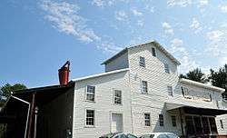
| 36 |
Hoots Milling Company Roller Mill |
|
May 19, 2014
(#14000227) |
1151 Canal Dr.
36°06′12″N 80°15′35″W / 36.1034°N 80.2597°W / 36.1034; -80.2597 (Hoots Milling Company Roller Mill) |
Winston-Salem |
|
| 37 |
Hylehurst |
|
July 21, 1983
(#83001878) |
224 S. Cherry St.
36°05′32″N 80°14′48″W / 36.092222°N 80.246667°W / 36.092222; -80.246667 (Hylehurst) |
Winston-Salem |
|
| 38 |
Indera Mills |
|
July 15, 1999
(#99000843) |
400 S. Marshall St.
36°05′22″N 80°14′50″W / 36.089444°N 80.247222°W / 36.089444; -80.247222 (Indera Mills) |
Winston-Salem |
|
| 39 |
Dr. Beverly Jones House |
|
January 20, 1978
(#78001947) |
SR 1611
36°11′36″N 80°20′12″W / 36.193333°N 80.336667°W / 36.193333; -80.336667 (Dr. Beverly Jones House) |
Bethania |
|
| 40 |
John Henry Kapp Farm |
|
August 31, 1992
(#92001087) |
North side NC 65, 0.1 miles (0.16 km) east of the junction with NC 67 (4647 Bethania-Tobaccoville Rd.)
36°10′59″N 80°21′33″W / 36.183056°N 80.359167°W / 36.183056; -80.359167 (John Henry Kapp Farm) |
Bethania |
|
| 41 |
Kernersville Depot |
|
February 25, 1988
(#88000133) |
121 Railroad St.
36°07′19″N 80°04′15″W / 36.121944°N 80.070833°W / 36.121944; -80.070833 (Kernersville Depot) |
Kernersville |
|
| 42 |
Korner's Folly |
|
March 20, 1973
(#73001340) |
413 S. Main St.
36°06′55″N 80°04′44″W / 36.1152195°N 80.0787574°W / 36.1152195; -80.0787574 (Korner's Folly) |
Kernersville |
|
| 43 |
Lloyd Presbyterian Church |
|
June 26, 1998
(#98000728) |
748 Chestnut St.
36°06′13″N 80°14′33″W / 36.103611°N 80.2425°W / 36.103611; -80.2425 (Lloyd Presbyterian Church) |
Winston-Salem |
|
| 44 |
Cicero Francis Lowe House |
|
December 20, 1984
(#84000535) |
204 Cascade Ave.
36°04′25″N 80°14′33″W / 36.073611°N 80.2425°W / 36.073611; -80.2425 (Cicero Francis Lowe House) |
Winston-Salem |
|
| 45 |
Col. Jacob Lott Ludlow House |
|
March 17, 1983
(#83001879) |
434 Summit St.
36°05′53″N 80°15′27″W / 36.098056°N 80.2575°W / 36.098056; -80.2575 (Col. Jacob Lott Ludlow House) |
Winston-Salem |
|
| 46 |
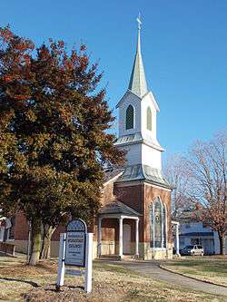
Mars Hill Baptist Church |
|
January 27, 1999
(#99000061) |
1331 E. Fourth St.
36°05′58″N 80°13′46″W / 36.099444°N 80.229444°W / 36.099444; -80.229444 (Mars Hill Baptist Church) |
Winston-Salem |
|
| 47 |
Isaac Harrison McKaughan House |
|
February 11, 1988
(#88000127) |
510 Salisbury St.
36°06′49″N 80°04′40″W / 36.113611°N 80.077778°W / 36.113611; -80.077778 (Isaac Harrison McKaughan House) |
Kernersville |
|
| 48 |
Memorial Industrial School |
|
August 13, 2015
(#15000529) |
100 Horizons Ln.
36°13′36″N 80°13′42″W / 36.2267°N 80.2283°W / 36.2267; -80.2283 (Memorial Industrial School) |
Rural Hall |
|
| 49 |
Middleton House |
|
December 28, 2000
(#00001552) |
2721 Robinhood Rd.
36°07′03″N 80°17′32″W / 36.1175°N 80.292222°W / 36.1175; -80.292222 (Middleton House) |
Winston-Salem |
|
| 50 |
Nissen Building |
|
March 17, 1983
(#83001880) |
310 W. 4th St.; also 314 W. 4th St.
36°05′31″N 80°15′14″W / 36.091944°N 80.253889°W / 36.091944; -80.253889 (Nissen Building) |
Winston-Salem |
314 W. 4th represents a boundary increase of August 25, 2004 |
| 51 |
S. J. Nissen Building |
|
August 16, 2007
(#07000820) |
310 E. Third St.
36°05′52″N 80°14′26″W / 36.097778°N 80.240556°W / 36.097778; -80.240556 (S. J. Nissen Building) |
Winston-Salem |
|
| 52 |
North Cherry Street Historic District |
|
February 25, 1988
(#88000118) |
1407-15, 1419, 1463, 2067 N. Cherry St.,
36°07′15″N 80°04′27″W / 36.120833°N 80.074167°W / 36.120833; -80.074167 (North Cherry Street Historic District) |
Kernersville |
|
| 53 |
North Cherry Street Historic District |
|
December 23, 2004
(#04001394) |
N. Cherry St. bounded by Fourteenth, Twenty-third and Seventeenth St., Lincoln and Pittsburg Ave.
36°06′27″N 80°15′19″W / 36.1075°N 80.255278°W / 36.1075; -80.255278 (North Cherry Street Historic District) |
Winston-Salem |
Boundary decrease June 20, 2014 |
| 54 |
O'Hanlon Building |
|
July 12, 1984
(#84002269) |
103 W. 4th St.
36°05′54″N 80°14′44″W / 36.098333°N 80.245556°W / 36.098333; -80.245556 (O'Hanlon Building) |
Winston-Salem |
|
| 55 |
Oak Crest Historic District |
|
December 20, 2016
(#16000877) |
1141-1537 Polo & Fred's Rds., Friendship, Crepe Myrtle & Rosedale Circles, Idlewilde Dr., Harmon Ave., Hobart St
36°08′17″N 80°17′10″W / 36.138154°N 80.285988°W / 36.138154; -80.285988 (Oak Crest Historic District) |
Winston-Salem |
|
| 56 |
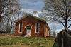
Oak Grove School |
|
December 31, 2002
(#02001668) |
Oak Grove Circle, 0.3 miles (0.48 km) east of the junction with Bethabara Rd.
36°10′20″N 80°19′16″W / 36.172222°N 80.321111°W / 36.172222; -80.321111 (Oak Grove School) |
Winston-Salem |
|
| 57 |
Old German Baptist Brethern Church |
|
December 1, 2014
(#14000984) |
4916 Charnel Rd.
36°00′40″N 80°20′30″W / 36.0111°N 80.3417°W / 36.0111; -80.3417 (Old German Baptist Brethern Church) |
Winston-Salem |
|
| 58 |
Old Richmond Schoolhouse and Gymnasium |
|
January 21, 2009
(#08001362) |
6315 and 6375 Tobaccoville Rd.
36°12′22″N 80°23′23″W / 36.206164°N 80.389608°W / 36.206164; -80.389608 (Old Richmond Schoolhouse and Gymnasium) |
Tobaccoville |
|
| 59 |
Old Salem Historic District |
|
November 13, 1966
(#66000591) |
Salem College campus and area near Salem Sq.
36°05′15″N 80°14′32″W / 36.0875°N 80.242222°W / 36.0875; -80.242222 (Old Salem Historic District) |
Winston-Salem |
|
| 60 |
J. W. Paisley House |
|
July 22, 1979
(#79001706) |
934 Stadium Dr.
36°05′24″N 80°13′38″W / 36.09°N 80.227222°W / 36.09; -80.227222 (J. W. Paisley House) |
Winston-Salem |
|
| 61 |
Pepper Building |
|
October 20, 2014
(#12000263) |
100-106 W. 4th St.
36°05′53″N 80°14′42″W / 36.0981°N 80.2451°W / 36.0981; -80.2451 (Pepper Building) |
Winston-Salem |
|
| 62 |
H. D. Poindexter Houses |
|
July 31, 1978
(#78001950) |
124 and 130 West End Blvd.
36°06′03″N 80°15′11″W / 36.100833°N 80.253056°W / 36.100833; -80.253056 (H. D. Poindexter Houses) |
Winston-Salem |
|
| 63 |
Reynolda Historic District |
|
November 28, 1980
(#80002833) |
Reynolda Rd.
36°07′37″N 80°16′52″W / 36.126944°N 80.281111°W / 36.126944; -80.281111 (Reynolda Historic District) |
Winston-Salem |
May include Reynolda House Museum of American Art |
| 64 |
Reynolds Building |
|
August 19, 2014
(#14000494) |
41 E. 4th St.
36°05′56″N 80°14′40″W / 36.0988°N 80.2444°W / 36.0988; -80.2444 (Reynolds Building) |
Winston-Salem |
|
| 65 |
Richard J. Reynolds High School and Richard J. Reynolds Memorial Auditorium |
|
January 11, 1991
(#90002139) |
301 Hawthorne Rd.
36°06′05″N 80°15′48″W / 36.101389°N 80.263333°W / 36.101389; -80.263333 (Richard J. Reynolds High School and Richard J. Reynolds Memorial Auditorium) |
Winston-Salem |
|
| 66 |
R.J. Reynolds Tobacco Company Buildings 2-1 and 2-2 |
|
October 26, 2017
(#100001631) |
951 Reynolds Blvd.
36°08′11″N 80°15′07″W / 36.136317°N 80.251939°W / 36.136317; -80.251939 (R.J. Reynolds Tobacco Company Buildings 2-1 and 2-2) |
Winston-Salem |
|
| 67 |
Reynoldstown Historic District |
|
February 28, 2008
(#08000111) |
Portions of 800 & 900 blks. of Camel, Cameron, Graham, Jackson & Rich Aves., E. 10th St.& Cameron Ave Bridge
36°06′18″N 80°13′22″W / 36.105064°N 80.222769°W / 36.105064; -80.222769 (Reynoldstown Historic District) |
Winston-Salem |
|
| 68 |
Richmond Courthouse Site |
|
January 5, 1984
(#84002273) |
Address Restricted
|
Donnaha |
|
| 69 |
Roberts-Justice House |
|
February 25, 1988
(#88000129) |
133 N. Main St.
36°07′13″N 80°04′23″W / 36.120278°N 80.073056°W / 36.120278; -80.073056 (Roberts-Justice House) |
Kernersville |
|
| 70 |
A. Robinson Building |
|
June 26, 1998
(#98000729) |
707-709 Patterson Ave.
36°06′10″N 80°14′28″W / 36.102778°N 80.241111°W / 36.102778; -80.241111 (A. Robinson Building) |
Winston-Salem |
|
| 71 |
James Mitchell Rogers House |
|
July 15, 1982
(#82003453) |
102 S. Cherry St.
36°05′38″N 80°14′50″W / 36.093889°N 80.247222°W / 36.093889; -80.247222 (James Mitchell Rogers House) |
Winston-Salem |
|
| 72 |
Rural Hall Depot |
|
July 21, 1983
(#83001881) |
Depot St. (SR 1646)
36°14′36″N 80°17′51″W / 36.243333°N 80.2975°W / 36.243333; -80.2975 (Rural Hall Depot) |
Rural Hall |
|
| 73 |
Salem Tavern |
|
October 15, 1966
(#66000592) |
800 S. Main St.
36°05′07″N 80°14′31″W / 36.085278°N 80.241944°W / 36.085278; -80.241944 (Salem Tavern) |
Winston-Salem |
|
| 74 |
Salem Town Hall |
|
March 17, 1983
(#83001882) |
301 S. Liberty St.
36°05′30″N 80°14′38″W / 36.091667°N 80.243889°W / 36.091667; -80.243889 (Salem Town Hall) |
Winston-Salem |
|
| 75 |
John Jacob Schaub House |
|
October 7, 1982
(#82001296) |
Northeast of Vienna off SR 1455
36°10′04″N 80°22′50″W / 36.167778°N 80.380556°W / 36.167778; -80.380556 (John Jacob Schaub House) |
Pfafftown |
|
| 76 |
Shamrock Mills |
|
May 23, 1978
(#78001951) |
3rd and Marshall Sts.
36°05′45″N 80°14′55″W / 36.095833°N 80.248611°W / 36.095833; -80.248611 (Shamrock Mills) |
Winston-Salem |
|
| 77 |
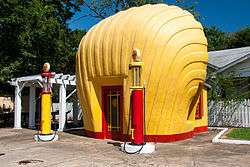
Shell Service Station |
|
May 13, 1976
(#76001322) |
Sprague and Peachtree Sts., NW
36°04′04″N 80°12′51″W / 36.067778°N 80.214167°W / 36.067778; -80.214167 (Shell Service Station) |
Winston-Salem |
|
| 78 |
Christian Thomas Shultz House |
|
December 16, 2005
(#05001413) |
3960 Walnut Hills Dr.
36°08′31″N 80°20′39″W / 36.141944°N 80.344167°W / 36.141944; -80.344167 (Christian Thomas Shultz House) |
Winston-Salem |
|
| 79 |
Single Brothers Industrial Complex Site |
|
December 13, 1979
(#79001707) |
Address Restricted
|
Winston-Salem |
|
| 80 |
Single Brothers' House |
|
April 15, 1970
(#70000454) |
S. Main and Academy Sts.
36°05′14″N 80°14′33″W / 36.087222°N 80.2425°W / 36.087222; -80.2425 (Single Brothers' House) |
Winston-Salem |
|
| 81 |
W. F. Smith and Sons Leaf House and Brown Brothers Company Building |
|
February 23, 1978
(#78001952) |
4th St. between Patterson and Linden
36°05′58″N 80°14′28″W / 36.099444°N 80.241111°W / 36.099444; -80.241111 (W. F. Smith and Sons Leaf House and Brown Brothers Company Building) |
Winston-Salem |
|
| 82 |
John Wesley Snyder House |
|
October 12, 2000
(#00001209) |
2715 Old Salisbury Rd.
36°01′30″N 80°16′27″W / 36.025°N 80.274167°W / 36.025; -80.274167 (John Wesley Snyder House) |
Winston-Salem |
|
| 83 |
Sosnik-Morris-Early Commercial Block |
|
April 5, 1984
(#84002293) |
500 W. 4th St.
36°05′31″N 80°15′14″W / 36.091944°N 80.253889°W / 36.091944; -80.253889 (Sosnik-Morris-Early Commercial Block) |
Winston-Salem |
|
| 84 |
South Main Street Historic District |
|
February 25, 1988
(#88000137) |
100-600 blks. of S. Main St.
36°06′55″N 80°04′42″W / 36.115278°N 80.078333°W / 36.115278; -80.078333 (South Main Street Historic District) |
Kernersville |
|
| 85 |
South Trade Street Houses |
|
December 11, 1978
(#78001953) |
434, 440, and 448 S. Trade St.
36°05′20″N 80°14′45″W / 36.088889°N 80.245833°W / 36.088889; -80.245833 (South Trade Street Houses) |
Winston-Salem |
|
| 86 |
William Henry and Sarah Hauser Speas House |
|
September 11, 2018
(#100002927) |
3991 River Ridge Rd.
36°09′50″N 80°25′35″W / 36.1640°N 80.4263°W / 36.1640; -80.4263 (William Henry and Sarah Hauser Speas House) |
Pfafftown vicinity |
|
| 87 |
Spruce Street YMCA |
|
July 12, 1984
(#84002296) |
315 N. Spruce St.
36°05′50″N 80°14′55″W / 36.097222°N 80.248611°W / 36.097222; -80.248611 (Spruce Street YMCA) |
Winston-Salem |
|
| 88 |
St. Philip's Moravian Church |
|
September 3, 1991
(#91001170) |
E side, S. Church St. near Race St., Old Salem
36°05′04″N 80°14′27″W / 36.084444°N 80.240833°W / 36.084444; -80.240833 (St. Philip's Moravian Church) |
Winston-Salem |
|
| 89 |
Samuel B. Stauber Farm |
|
January 12, 1988
(#87002232) |
SR 1611
36°11′58″N 80°20′57″W / 36.199444°N 80.349167°W / 36.199444; -80.349167 (Samuel B. Stauber Farm) |
Bethania |
|
| 90 |
Stuart Motor Company |
|
February 25, 1988
(#88000139) |
109-111 E. Mountain St.
36°07′11″N 80°04′22″W / 36.119722°N 80.072778°W / 36.119722; -80.072778 (Stuart Motor Company) |
Kernersville |
|
| 91 |
Sunnyside-Central Terrace Historic District |
|
May 8, 2008
(#08000380) |
Roughly bounded by Haled, Junia, Monmouth, Glendale, Goldfloss, Brookline & Main Sts.
36°04′12″N 80°14′03″W / 36.069881°N 80.23425°W / 36.069881; -80.23425 (Sunnyside-Central Terrace Historic District) |
Winston-Salem |
|
| 92 |
Union Station |
|
December 24, 1998
(#98001547) |
300 Martin Luther King, Jr., Dr.
36°05′36″N 80°13′42″W / 36.093333°N 80.228333°W / 36.093333; -80.228333 (Union Station) |
Winston-Salem |
|
| 93 |
Wachovia Bank and Trust Company Building |
|
May 31, 1984
(#84002306) |
8 W. 3rd St.
36°05′50″N 80°14′39″W / 36.097222°N 80.244167°W / 36.097222; -80.244167 (Wachovia Bank and Trust Company Building) |
Winston-Salem |
|
| 94 |
Wachovia Building |
|
April 19, 2001
(#01000376) |
301 N. Main St.
36°05′53″N 80°14′37″W / 36.098056°N 80.243611°W / 36.098056; -80.243611 (Wachovia Building) |
Winston-Salem |
|
| 95 |
Waller House |
|
August 25, 2014
(#14000519) |
9186 Reynolda Rd.
36°12′20″N 80°24′57″W / 36.2056°N 80.4159°W / 36.2056; -80.4159 (Waller House) |
Pfafftown |
|
| 96 |
Washington Park Historic District |
|
January 13, 1992
(#91001960) |
Roughly bounded by Leonard St., Acadia Ave., Sunnyside Ave., Vintage Ave., Broad St., Bond St. and Washington Park
36°04′25″N 80°14′38″W / 36.073611°N 80.243889°W / 36.073611; -80.243889 (Washington Park Historic District) |
Winston-Salem |
|
| 97 |
Waughtown-Belview Historic District |
|
January 20, 2005
(#04001521) |
Roughly bounded by Dacian, Waughtown St, Bellwauwood, Sprague, Ernest, Goldfloss, and Gilbreath Dr.
36°04′03″N 80°12′42″W / 36.0675°N 80.211667°W / 36.0675; -80.211667 (Waughtown-Belview Historic District) |
Winston-Salem |
|
| 98 |
West End Historic District |
|
December 4, 1986
(#86003442) |
Roughly bounded by W. End Blvd., Sixth, Broad, and Fourth Sts., I-40, Sunset Dr., and Peters Creek
36°05′48″N 80°15′32″W / 36.096667°N 80.258889°W / 36.096667; -80.258889 (West End Historic District) |
Winston-Salem |
|
| 99 |
West Salem Historic District |
|
January 19, 2005
(#04001524) |
Roughly bounded by Business 40, Poplar, Salem Ave., Walnut, Shober, Hutton Sts, Granville Dr. and Beaumont St.
36°05′12″N 80°14′58″W / 36.086667°N 80.249444°W / 36.086667; -80.249444 (West Salem Historic District) |
Winston-Salem |
|
| 100 |
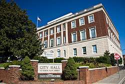
Winston-Salem City Hall |
|
October 20, 2001
(#01001130) |
101 S. Main St.
36°05′42″N 80°14′36″W / 36.095°N 80.243333°W / 36.095; -80.243333 (Winston-Salem City Hall) |
Winston-Salem |
|
| 101 |
Winston-Salem Southbound Railway Freight Warehouse and Office |
|
November 29, 1991
(#91001747) |
300 S. Liberty St.
36°05′30″N 80°14′40″W / 36.091667°N 80.244444°W / 36.091667; -80.244444 (Winston-Salem Southbound Railway Freight Warehouse and Office) |
Winston-Salem |
|
| 102 |
Winston-Salem Tobacco Historic District |
|
August 5, 2009
(#09000602) |
Bounded by Chestnut St. on the W., 5th and 7th Sts. on the N., Linden St. on the E., and 4th and Fogle Sts. on the S.
36°06′02″N 80°14′24″W / 36.100419°N 80.239986°W / 36.100419; -80.239986 (Winston-Salem Tobacco Historic District) |
Winston-Salem |
|
| 103 |
Zevely House |
|
April 24, 1973
(#73001341) |
901 West Fourth Street
36°05′49″N 80°15′26″W / 36.096944°N 80.257222°W / 36.096944; -80.257222 (Zevely House) |
Winston-Salem |
Moved to its present location from 734 Oak St. in 1974. |
.jpg)
%2C_Old_Town_(Forsyth_County%2C_North_Carolina).jpg)
_House.jpg)

.jpg)