Cumberland County, North Carolina
| Cumberland County, North Carolina | ||
|---|---|---|
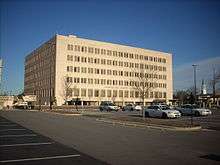 Cumberland County Courthouse in Fayetteville | ||
| ||
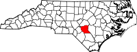 Location in the U.S. state of North Carolina | ||
 North Carolina's location in the U.S. | ||
| Founded | 1754 | |
| Named for | Prince William, Duke of Cumberland | |
| Seat | Fayetteville | |
| Largest city | Fayetteville | |
| Area | ||
| • Total | 658 sq mi (1,704 km2) | |
| • Land | 652 sq mi (1,689 km2) | |
| • Water | 6.1 sq mi (16 km2), 0.9% | |
| Population (est.) | ||
| • (2017) | 332,546 | |
| • Density | 500.5/sq mi (193.2/km2) | |
| Congressional districts | 8th, 9th | |
| Time zone | Eastern: UTC−5/−4 | |
| Website |
www | |

Cumberland County is a county located in the U.S. state of North Carolina. As of the 2010 census, the population was 319,431,[1] making it the fifth-most populous county in North Carolina. Its county seat is Fayetteville.[2]
Cumberland County is part of the Fayetteville, NC Metropolitan Statistical Area.
History
The county was formed in 1754 from Bladen County. It was named for Prince William Augustus, Duke of Cumberland (1721-1765), captain-general of the British army and victorious commander at the Battle of Culloden.
In 1771 parts of Cumberland County, Johnston County, and Orange County were combined to form Wake County. In July 1784 the western part of Cumberland County became Moore County; the eastern part became Fayette County in honor of the Marquis de la Fayette, but the name Cumberland County was restored three months later. In 1855 the northern part of Cumberland County became Harnett County. Finally, in 1911 parts of Cumberland County and Robeson County were combined to form Hoke County.
Geography
According to the U.S. Census Bureau, the county has a total area of 658 square miles (1,700 km2), of which 652 square miles (1,690 km2) is land and 6.1 square miles (16 km2) (0.9%) is water.[3]
Major highways
Demographics
| Historical population | |||
|---|---|---|---|
| Census | Pop. | %± | |
| 1790 | 8,730 | — | |
| 1800 | 9,264 | 6.1% | |
| 1810 | 9,382 | 1.3% | |
| 1820 | 14,446 | 54.0% | |
| 1830 | 14,834 | 2.7% | |
| 1840 | 15,284 | 3.0% | |
| 1850 | 20,610 | 34.8% | |
| 1860 | 16,369 | −20.6% | |
| 1870 | 17,035 | 4.1% | |
| 1880 | 23,836 | 39.9% | |
| 1890 | 27,321 | 14.6% | |
| 1900 | 29,249 | 7.1% | |
| 1910 | 35,284 | 20.6% | |
| 1920 | 35,064 | −0.6% | |
| 1930 | 45,219 | 29.0% | |
| 1940 | 59,320 | 31.2% | |
| 1950 | 96,006 | 61.8% | |
| 1960 | 148,418 | 54.6% | |
| 1970 | 212,042 | 42.9% | |
| 1980 | 247,160 | 16.6% | |
| 1990 | 274,566 | 11.1% | |
| 2000 | 302,963 | 10.3% | |
| 2010 | 319,431 | 5.4% | |
| Est. 2017 | 332,546 | [4] | 4.1% |
| U.S. Decennial Census[5] 1790-1960[6] 1900-1990[7] 1990-2000[8] 2010-2013[1] | |||
As of the census[9] of 2000, there were 302,963 people, 107,358 households, and 77,619 families residing in the county. The population density was 464 people per square mile (179/km²). There were 118,425 housing units at an average density of 181 per square mile (70/km²). The racial makeup of the county was 55.15% White, 34.90% Black or African American, 1.55% Native American, 1.88% Asian, 0.30% Pacific Islander, 3.13% from other races, and 3.09% from two or more races. 6.90% of the population were Hispanic or Latino of any race.
By 2005 Cumberland County's population was 51.5% non-Hispanic whites. It was 36.7% African-American. 6.4% of the population was Latino. 3.1% of the population reported more than one race. 2.1% of the population was Asian. 1.7% of the population was Native American.
There were 107,358 households out of which 39.40% had children under the age of 18 living with them, 52.90% were married couples living together, 15.50% had a female householder with no husband present, and 27.70% were non-families. 22.40% of all households were made up of individuals and 5.90% had someone living alone who was 65 years of age or older. The average household size was 2.65 and the average family size was 3.11.
In the county, the population was spread out with 27.90% under the age of 18, 13.70% from 18 to 24, 32.90% from 25 to 44, 17.80% from 45 to 64, and 7.70% who were 65 years of age or older. The median age was 30 years. For every 100 females there were 102.30 males. For every 100 females age 18 and over, there were 101.90 males.
The median income for a household in the county was $37,466, and the median income for a family was $41,459. Males had a median income of $28,308 versus $22,379 for females. The per capita income for the county was $17,376. About 10.40% of families and 12.80% of the population were below the poverty line, including 16.80% of those under age 18 and 13.70% of those age 65 or over.
Law and government
Cumberland County is a member of the regional Mid-Carolina Council of Governments.
| Year | Republican | Democratic | Third parties |
|---|---|---|---|
| 2016 | 40.2% 51,265 | 56.2% 71,605 | 3.6% 4,636 |
| 2012 | 39.7% 50,666 | 59.4% 75,792 | 0.9% 1,183 |
| 2008 | 40.9% 52,151 | 58.6% 74,693 | 0.6% 731 |
| 2004 | 51.6% 49,139 | 48.1% 45,788 | 0.3% 299 |
| 2000 | 49.4% 38,129 | 50.1% 38,626 | 0.5% 396 |
| 1996 | 44.8% 29,804 | 49.3% 32,739 | 5.9% 3,936 |
| 1992 | 42.1% 27,139 | 47.0% 30,291 | 10.9% 7,040 |
| 1988 | 53.1% 27,057 | 46.7% 23,789 | 0.3% 133 |
| 1984 | 58.2% 31,602 | 41.6% 22,614 | 0.2% 103 |
| 1980 | 47.6% 21,540 | 48.8% 22,073 | 3.6% 1,615 |
| 1976 | 36.8% 14,226 | 62.8% 24,297 | 0.4% 160 |
| 1972 | 70.5% 24,376 | 28.5% 9,853 | 1.1% 366 |
| 1968 | 32.0% 9,143 | 34.7% 9,938 | 33.3% 9,539 |
| 1964 | 39.6% 9,093 | 60.4% 13,864 | |
| 1960 | 41.0% 8,072 | 59.0% 11,601 | |
| 1956 | 43.1% 6,699 | 57.0% 8,862 | |
| 1952 | 45.8% 7,474 | 54.2% 8,839 | |
| 1948 | 19.2% 1,741 | 55.1% 4,996 | 25.7% 2,325 |
| 1944 | 23.3% 2,014 | 76.7% 6,615 | |
| 1940 | 15.6% 1,118 | 84.4% 6,050 | |
| 1936 | 13.6% 1,024 | 86.4% 6,505 | |
| 1932 | 15.6% 931 | 83.8% 5,012 | 0.7% 40 |
| 1928 | 51.7% 3,534 | 48.3% 3,297 | |
| 1924 | 31.7% 1,372 | 67.5% 2,923 | 0.9% 37 |
| 1920 | 37.9% 1,972 | 62.1% 3,233 | |
| 1916 | 38.2% 1,217 | 61.8% 1,971 | |
| 1912 | 8.4% 235 | 60.1% 1,678 | 31.5% 880 |
Education
Cumberland County is home to Fayetteville State University (an HBCU in the CIAA Conference), Methodist University (a member of the USA South Athletic Conference), and Fayetteville Technical Community College.
The Cumberland County Schools system is the fourth largest Public school system in the state of North Carolina. There are 17 high schools in Cumberland County: Cape Fear, Cross Creek Early College, Cumberland International Early College, Douglas Byrd, E.E. Smith, Fuller Performance Learning Center, Gray's Creek, Howard Health and Life Sciences, Jack Britt, Massey Hill Classical, Pine Forest, Reid Ross Classical, Seventy-First, South View, Terry Sanford, Alger B. Wilkins, Ramsey Street, and Westover.
Communities
City
Towns
Census-designated place
Other unincorporated communities
Townships
- Beaver Dam
- Black River
- Carvers Creek
- Cedar Creek
- Cross Creek
- Eastover
- Gray's Creek
- Manchester
- Pearces Mill
- Rockfish
- Seventy-First
See also
References
- 1 2 "State & County QuickFacts". United States Census Bureau. Retrieved October 18, 2013.
- ↑ "Find a County". National Association of Counties. Archived from the original on 2011-05-31. Retrieved 2011-06-07.
- ↑ "2010 Census Gazetteer Files". United States Census Bureau. August 22, 2012. Archived from the original on January 12, 2015. Retrieved January 13, 2015.
- ↑ "Population and Housing Unit Estimates". Retrieved June 9, 2017.
- ↑ "U.S. Decennial Census". United States Census Bureau. Archived from the original on May 12, 2015. Retrieved January 13, 2015.
- ↑ "Historical Census Browser". University of Virginia Library. Retrieved January 13, 2015.
- ↑ Forstall, Richard L., ed. (March 27, 1995). "Population of Counties by Decennial Census: 1900 to 1990". United States Census Bureau. Retrieved January 13, 2015.
- ↑ "Census 2000 PHC-T-4. Ranking Tables for Counties: 1990 and 2000" (PDF). United States Census Bureau. April 2, 2001. Retrieved January 13, 2015.
- ↑ "American FactFinder". United States Census Bureau. Archived from the original on 2013-09-11. Retrieved 2008-01-31.
- ↑ Leip, David. "Dave Leip's Atlas of U.S. Presidential Elections". uselectionatlas.org. Retrieved 2018-03-15.
External links
| Wikimedia Commons has media related to Cumberland County, North Carolina. |
- Cumberland County government official website
- Cumberland County Schools
- Cumberland County Business Council
- Cumberland County Job Listings
Places adjacent to Cumberland County, North Carolina | ||||||||||
|---|---|---|---|---|---|---|---|---|---|---|
| ||||||||||
Municipalities and communities of Cumberland County, North Carolina, United States | ||
|---|---|---|
| City | 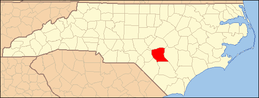 | |
| Towns | ||
| CDP | ||
| Unincorporated communities | ||
| Military bases | ||
| Footnotes | ‡This populated place also has portions in an adjacent county or counties | |
