Cumberland, North Carolina
| Cumberland, North Carolina | |
|---|---|
| Unincorporated community | |
 Cumberland, North Carolina  Cumberland, North Carolina | |
| Coordinates: 35°00′18″N 78°58′02″W / 35.00500°N 78.96722°WCoordinates: 35°00′18″N 78°58′02″W / 35.00500°N 78.96722°W | |
| Country | United States |
| State | North Carolina |
| County | Cumberland |
| Elevation | 184 ft (56 m) |
| Time zone | UTC-5 (Eastern (EST)) |
| • Summer (DST) | UTC-4 (EDT) |
| ZIP code | 28331 |
| Area code(s) | 910 |
| GNIS feature ID | 1019882[1] |
Cumberland is an unincorporated community in Cumberland County, North Carolina, United States. The community is located between Fayetteville to the north and Hope Mills on North Carolina Highway 59; parts of the community have been annexed by the two cities. Cumberland has a post office with ZIP code 28331.[2][3]
References
- ↑ "Cumberland". Geographic Names Information System. United States Geological Survey.
- ↑ United States Postal Service (2015). "USPS - Look Up a ZIP Code". Retrieved February 10, 2015.
- ↑ "Postmaster Finder - Post Offices by ZIP Code". United States Postal Service. Retrieved February 10, 2015.
Municipalities and communities of Cumberland County, North Carolina, United States | ||
|---|---|---|
| City | 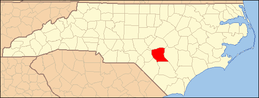 | |
| Towns | ||
| CDP | ||
| Unincorporated communities | ||
| Military bases | ||
| Footnotes | ‡This populated place also has portions in an adjacent county or counties | |
This article is issued from
Wikipedia.
The text is licensed under Creative Commons - Attribution - Sharealike.
Additional terms may apply for the media files.