North Carolina Highway 111
| ||||
|---|---|---|---|---|
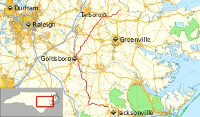 Route of NC 111 highlighted in red | ||||
| Route information | ||||
| Maintained by NCDOT | ||||
| Length | 126.0 mi[1] (202.8 km) | |||
| Major junctions | ||||
| South end |
| |||
| North end |
| |||
| Location | ||||
| Counties | Onslow, Duplin, Wayne, Wilson, Edgecombe, Martin | |||
| Highway system | ||||
| ||||

North Carolina Highway 111 (NC 111) is a 126.0-mile-long (202.8 km) primary state highway in the U.S. state of North Carolina. Traveling north–south through Eastern North Carolina, it connects the various rural towns and communities with the cities of Jacksonville (via U.S. Route 258 (US 258) and NC 24), Goldsboro and Tarboro.
Junction list
| County | Location | mi[1] | km | Destinations | Notes |
|---|---|---|---|---|---|
| Onslow | Catherine Lake | 0.0 | 0.0 | Southern terminus | |
| Duplin | Chinquapin | 17.1 | 27.5 | Southern end of NC 41 concurrency | |
| Beulaville | 24.2 | 38.9 | Southern end of NC 241 concurrency | ||
| 24.5 | 39.4 | Northern end of NC 41 / NC 241 concurrencies | |||
| Kornegay | 34.7 | 55.8 | Southern end of NC 11 concurrency | ||
| 35.0 | 56.3 | Northern end of NC 11 concurrency; southern end of NC 903 concurrency | |||
| Albertson | 39.1 | 62.9 | Northern end of NC 903 concurrency | ||
| Wayne | Hines Crossroads | 47.0 | 75.6 | ||
| Goldsboro | 55.4 | 89.2 | Southern terminus of NC 581 | ||
| 57.8 | 93.0 | Southern end of US 70 concurrency | |||
| 58.7 | 94.5 | Eastern terminus of US 70 Bus. | |||
| 60.1– 60.4 | 96.7– 97.2 | Diamond interchange; southern end of US 13 concurrency | |||
| 61.0– 61.4 | 98.2– 98.8 | Cuyler Best Road / Spence Avenue | Partial cloverleaf interchange | ||
| 62.2– 62.7 | 100.1– 100.9 | Wayne Memorial Drive – Goldsboro High School, Wayne Community College | Partial cloverleaf interchange | ||
| 63.3– 63.5 | 101.9– 102.2 | Northern end of US 13 / US 70 concurrencies; southern end of US 117 Bus. Concurrency | |||
| 64.1 | 103.2 | Northern end of US 117 Bus. Concurrency | |||
| | 75.2 | 121.0 | Western end of NC 222 concurrency | ||
| Wilson | Stantonsburg | 82.8 | 133.3 | Southern end of NC 58 concurrency | |
| 83.1 | 133.7 | Northern end of NC 58 concurrency | |||
| Saratoga | 87.3 | 140.5 | |||
| | 88.3– 88.5 | 142.1– 142.4 | Exit 53 (US 264) | ||
| | 88.6 | 142.6 | Eastern end of NC 222 concurrency | ||
| Edgecombe | | 96.0 | 154.5 | ||
| | 98.7 | 158.8 | |||
| | 100.6 | 161.9 | |||
| | 101.7 | 163.7 | Southern end of NC 122 concurrency | ||
| Tarboro | 106.5 | 171.4 | Northern end of NC 122 concurrency | ||
| 108.8 | 175.1 | Southern end of US 64 Alt. / NC 122 concurrency | |||
| 109.1– 109.7 | 175.6– 176.5 | Western end of US 64 Alt. concurrency; Eastern end of US 64 / US 258 concurrencies; exit 485 (US 64) | |||
| Princeville | 110.3– 110.7 | 177.5– 178.2 | Western end of US 64 concurrency; eastern end of US 64 Alt. concurrency; exit 486 (US 64); access from southbound NC 111 to westbound US 64 / eastbound US 64 to northbound NC 111 only | ||
| 111.0 | 178.6 | Northern end of US 64 Alt. concurrency | |||
| 111.4 | 179.3 | Northern end of US 258 / NC 122 concurrencies | |||
| Fountain Fork | 121.0 | 194.7 | Western terminus of NC 142 | ||
| Martin | Oak City | 126.0 | 202.8 | Northern terminus | |
1.000 mi = 1.609 km; 1.000 km = 0.621 mi
| |||||
North Carolina Highway 402
| |
|---|---|
| Location | Goldsboro, North Carolina |
| Length | 1.8 mi[2] (2.9 km) |
| Existed | 1933–1935 |
North Carolina Highway 402 (NC 402) was established as a spur primary highway from US 1/US 17/NC 40 in Goldsboro to Cherry Hospital via Ash Street. In 1935, it was renumbered as part of NC 111.
References
- 1 2 Google (May 4, 2015). "North Carolina Highway 111" (Map). Google Maps. Google. Retrieved May 4, 2015.
- ↑ Google (March 7, 2016). "North Carolina Highway 402" (Map). Google Maps. Google. Retrieved March 7, 2016.
External links

- NCRoads.com: N.C. 111
- NCRoads.com: N.C. 402
This article is issued from
Wikipedia.
The text is licensed under Creative Commons - Attribution - Sharealike.
Additional terms may apply for the media files.