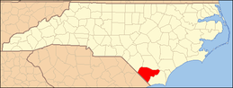
National Register of Historic Places listings in Columbus County, North Carolina
This list includes properties and districts listed on the National Register of Historic Places in Columbus County, North Carolina. Click the "Map of all coordinates" link to the right to view a Google map of all properties and districts with latitude and longitude coordinates in the table below.[1]
Current listings
- This National Park Service list is complete through NPS recent listings posted June 26, 2020.[2]
| [3] | Name on the Register | Image | Date listed[4] | Location | City or town | Description |
|---|---|---|---|---|---|---|
| 1 | Black Rock Plantation House |  Black Rock Plantation House |
August 18, 2014 (#14000492) |
7875 Old Stage Rd. 34°23′03″N 78°17′30″W |
Riegelwood | |
| 2 | Columbus County Courthouse | 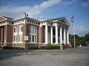 Columbus County Courthouse |
May 10, 1979 (#79001695) |
Bounded by Madison and Jefferson Sts. circle 34°20′16″N 78°42′17″W |
Whiteville | |
| 3 | Dr. Neil and Nancy Elizabeth Culbreth House | January 5, 2016 (#15000955) |
251 Washington St. 34°20′21″N 78°42′25″W |
Whiteville | ||
| 4 | Lake Waccamaw Depot |  Lake Waccamaw Depot |
July 21, 1983 (#83001842) |
Flemington Ave. 34°19′12″N 78°31′20″W |
Lake Waccamaw | |
| 5 | Powell House | January 31, 1978 (#78001940) |
Main and Orange Sts. 34°18′42″N 79°02′27″W |
Fair Bluff | ||
| 6 | Tabor City Commercial Historic District | December 15, 2015 (#15000899) |
Includes Hickman Rd., W. 5th, E. and W. 4th, and S. Main Sts. 34°08′54″N 78°52′38″W |
Tabor City |
See also
| Wikimedia Commons has media related to National Register of Historic Places in Columbus County, North Carolina. |
References
- The latitude and longitude information provided in this table was derived originally from the National Register Information System, which has been found to be fairly accurate for about 99% of listings. Some locations in this table may have been corrected to current GPS standards.
- "National Register of Historic Places: Weekly List Actions". National Park Service, United States Department of the Interior. Retrieved on June 26, 2020.
- Numbers represent an ordering by significant words. Various colorings, defined here, differentiate National Historic Landmarks and historic districts from other NRHP buildings, structures, sites or objects.
- The eight-digit number below each date is the number assigned to each location in the National Register Information System database, which can be viewed by clicking the number.

| Topics | |
|---|---|
| Lists by state |
|
| Lists by insular areas | |
| Lists by associated state | |
| Other areas | |
| Related | |
| |
Municipalities and communities of Columbus County, North Carolina, United States | ||
|---|---|---|
| City | | |
| Towns | ||
| CDPs | ||
| Unincorporated communities | ||
This article is issued from Wikipedia. The text is licensed under Creative Commons - Attribution - Sharealike. Additional terms may apply for the media files.