National Register of Historic Places listings in Union County, North Carolina
This list includes properties and districts listed on the National Register of Historic Places in Union County, North Carolina. Click the "Map of all coordinates" link to the right to view a Google map of all properties and districts with latitude and longitude coordinates in the table below.[1]
Current listings
- This National Park Service list is complete through NPS recent listings posted June 19, 2020.[2]
| [3] | Name on the Register[4] | Image | Date listed[5] | Location | City or town | Description |
|---|---|---|---|---|---|---|
| 1 | Malcolm K. Lee House |  Malcolm K. Lee House |
January 5, 1988 (#87002200) |
Main Street 34°58′39″N 80°32′03″W |
Monroe | Currently operating as a funeral home |
| 2 | Monroe City Hall |  Monroe City Hall |
July 27, 1971 (#71000619) |
102 W. Jefferson St. 34°59′01″N 80°32′59″W |
Monroe | |
| 3 | Monroe Downtown Historic District |  Monroe Downtown Historic District |
January 6, 1988 (#87002202) |
Roughly bounded by Jefferson, Church, Windsor & Stewart Sts. 34°58′55″N 80°33′00″W |
Monroe | |
| 4 | Monroe Residential Historic District | _1.jpg) Monroe Residential Historic District |
January 6, 1988 (#87002204) |
Roughly bounded by Hough, Franklin, Jefferson, McCarten, Windsor, Sanford, Washington. Braden, Church & Hudson Sts. 34°58′45″N 80°33′01″W |
Monroe | |
| 5 | Piedmont Buggy Factory |  Piedmont Buggy Factory |
June 2, 2004 (#04000569) |
514 Miller St. 34°59′20″N 80°32′46″W |
Monroe | |
| 6 | Pleasant Grove Camp Meeting Ground |  Pleasant Grove Camp Meeting Ground |
April 3, 1973 (#73001370) |
NE of Waxhaw on SR 1327 34°57′18″N 80°41′02″W |
Waxhaw | |
| 7 | John C. Sikes House |  John C. Sikes House |
April 15, 1982 (#82003518) |
1301 E. Franklin St. 34°58′31″N 80°31′37″W |
Monroe | |
| 8 | Union County Courthouse | .jpg) Union County Courthouse |
June 24, 1971 (#71000620) |
Courthouse Sq. 34°58′59″N 80°33′00″W |
Monroe | |
| 9 | US Post Office-Monroe |  US Post Office-Monroe |
March 6, 1985 (#85000482) |
407 N. Main St. 34°59′01″N 80°33′03″W |
Monroe | |
| 10 | Waxhaw Historic District | 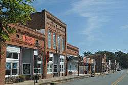 Waxhaw Historic District |
December 6, 1991 (#91001773) |
Portions of Main, Broad, Church, Broom, Providence, Old Providence, Brevard and McKibben Sts. 34°55′25″N 80°44′39″W |
Waxhaw | |
| 11 | Waxhaw-Weddington Roads Historic District |  Waxhaw-Weddington Roads Historic District |
January 5, 1988 (#87002201) |
Jct. of NC 75, NC 34 & W. Franklin St. 34°58′58″N 80°34′19″W |
Monroe | |
| 12 | Wingate Commercial Historic District | December 1, 2014 (#14000992) |
203, 205, 207-209, 211 Main St. 34°59′03″N 80°26′56″W |
Wingate |
See also
| Wikimedia Commons has media related to National Register of Historic Places in Union County, North Carolina. |
References
- The latitude and longitude information provided in this table was derived originally from the National Register Information System, which has been found to be fairly accurate for about 99% of listings. Some locations in this table may have been corrected to current GPS standards.
- "National Register of Historic Places: Weekly List Actions". National Park Service, United States Department of the Interior. Retrieved on June 19, 2020.
- Numbers represent an ordering by significant words. Various colorings, defined here, differentiate National Historic Landmarks and historic districts from other NRHP buildings, structures, sites or objects.
- "National Register Information System". National Register of Historic Places. National Park Service. April 24, 2008.
- The eight-digit number below each date is the number assigned to each location in the National Register Information System database, which can be viewed by clicking the number.

| Topics | |
|---|---|
| Lists by state |
|
| Lists by insular areas | |
| Lists by associated state | |
| Other areas | |
| Related | |
| |
Municipalities and communities of Union County, North Carolina, United States | ||
|---|---|---|
| City | | |
| Towns | ||
| Villages | ||
| CDP | ||
| Unincorporated communities | ||
| Ghost town | ||
| Footnotes | ‡This populated place also has portions in an adjacent county or counties | |
This article is issued from Wikipedia. The text is licensed under Creative Commons - Attribution - Sharealike. Additional terms may apply for the media files.