National Register of Historic Places listings in Scotland County, North Carolina
This list includes properties and districts listed on the National Register of Historic Places in Scotland County, North Carolina. Click the "Map of all coordinates" link to the right to view an online map of all properties and districts with latitude and longitude coordinates in the table below.[1]

Current listings
- This National Park Service list is complete through NPS recent listings posted June 19, 2020.[2]
| [3] | Name on the Register[4] | Image | Date listed[5] | Location | City or town | Description |
|---|---|---|---|---|---|---|
| 1 | John Blue House |  John Blue House |
December 8, 1978 (#78003192) |
West of Laurinburg on SR 1108 34°45′26″N 79°29′56″W |
Laurinburg | |
| 2 | Mag Blue House | September 23, 1982 (#82003512) |
West of Laurinburg on SR 1118 34°46′06″N 79°30′44″W |
Laurinburg | ||
| 3 | Central School | 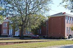 Central School |
January 20, 2005 (#04001525) |
303 McRae St. 34°46′15″N 79°27′38″W |
Laurinburg | |
| 4 | Dr. Evan Alexander Erwin House |  Dr. Evan Alexander Erwin House |
April 19, 2007 (#07000353) |
520 S. Main St. 34°46′16″N 79°27′50″W |
Laurinburg | |
| 5 | E. Hervey Evans House |  E. Hervey Evans House |
April 5, 2006 (#06000224) |
400 W. Church St. 34°46′31″N 79°28′00″W |
Laurinburg | |
| 6 | Thomas J. Gill House |  Thomas J. Gill House |
July 15, 1982 (#82003513) |
203 Cronly St. 34°46′31″N 79°27′50″W |
Laurinburg | |
| 7 | Laurel Hill Presbyterian Church | 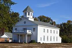 Laurel Hill Presbyterian Church |
August 18, 1983 (#83001915) |
SR 1321 and SR 1323 34°49′56″N 79°27′54″W |
Laurinburg | |
| 8 | Laurinburg Commercial Historic District | 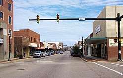 Laurinburg Commercial Historic District |
December 10, 2003 (#03001274) |
Roughly bounded by Church, Atkinson, Biggs Sts. and the Laurinburg and Southern RR 34°46′34″N 79°27′45″W |
Laurinburg | |
| 9 | McRae-McQueen House | November 25, 1980 (#80004469) |
SW of Johns on US 501 34°43′09″N 79°27′18″W |
Johns | ||
| 10 | Robert Nancy Monroe House | March 17, 1983 (#83001916) |
SR 1328 34°53′10″N 79°28′50″W |
Silver Hill | ||
| 11 | Richmond Temperance and Literary Society Hall | April 11, 1973 (#73001368) |
1 miles SW of Wagram on SR 1405 34°53′04″N 79°23′17″W |
Wagram | ||
| 12 | St. Andrews Presbyterian College |  St. Andrews Presbyterian College |
August 22, 2016 (#16000562) |
1700 Dogwood Mile 34°44′36″N 79°28′48″W |
Laurinburg | |
| 13 | Shaw Family Farms | 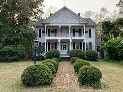 Shaw Family Farms |
October 13, 1983 (#83003999) |
SR 1405 34°52′30″N 79°23′54″W |
Wagram | |
| 14 | Stewart-Hawley-Malloy House | August 1, 1975 (#75001291) |
SE of Laurinburg at jct. of SR 1610 and 1609 34°44′35″N 79°25′01″W |
Laurinburg | ||
| 15 | Villa Nova | August 26, 1982 (#82003514) |
SR 1438 34°46′26″N 79°25′30″W |
Laurinburg |
See also
| Wikimedia Commons has media related to National Register of Historic Places in Scotland County, North Carolina. |
References
- The latitude and longitude information provided in this table was derived originally from the National Register Information System, which has been found to be fairly accurate for about 99% of listings. Some locations in this table may have been corrected to current GPS standards.
- "National Register of Historic Places: Weekly List Actions". National Park Service, United States Department of the Interior. Retrieved on June 19, 2020.
- Numbers represent an ordering by significant words. Various colorings, defined here, differentiate National Historic Landmarks and historic districts from other NRHP buildings, structures, sites or objects.
- "National Register Information System". National Register of Historic Places. National Park Service. April 24, 2008.
- The eight-digit number below each date is the number assigned to each location in the National Register Information System database, which can be viewed by clicking the number.

| Topics | |
|---|---|
| Lists by state |
|
| Lists by insular areas | |
| Lists by associated state | |
| Other areas | |
| Related | |
| |
Municipalities and communities of Scotland County, North Carolina, United States | ||
|---|---|---|
| City | | |
| Towns | ||
| Townships |
| |
| CDPs | ||
| Unincorporated community | ||
| Footnotes | ‡This populated place also has portions in an adjacent county or counties | |
This article is issued from Wikipedia. The text is licensed under Creative Commons - Attribution - Sharealike. Additional terms may apply for the media files.