National Register of Historic Places listings in Camden County, North Carolina
This list includes properties and districts listed on the National Register of Historic Places in Camden County, North Carolina. Click the "Map of all coordinates" link to the right to view an online map of all properties and districts with latitude and longitude coordinates in the table below.[1]

Current listings
- This National Park Service list is complete through NPS recent listings posted June 26, 2020.[2]
| [3] | Name on the Register | Image | Date listed[4] | Location | City or town | Description |
|---|---|---|---|---|---|---|
| 1 | William Riley Abbott House |  William Riley Abbott House |
August 11, 1978 (#78001936) |
SE of South Mills on SR 1224 36°25′54″N 76°17′55″W |
South Mills | |
| 2 | C.S.S. BLACK WARRIOR (two-masted schooner) | August 24, 2018 (#100002799) |
Address Restricted |
Elizabeth City | ||
| 3 | Camden County Courthouse | .jpg) Camden County Courthouse |
February 1, 1972 (#72000928) |
NC 343 36°19′48″N 76°10′18″W |
Camden | |
| 4 | Camden County Jail |  Camden County Jail |
May 3, 1984 (#84001950) |
NC 343 36°19′45″N 76°10′28″W |
Camden | |
| 5 | Dismal Swamp Canal | 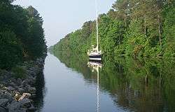 Dismal Swamp Canal |
June 6, 1988 (#88000528) |
Runs between Chesapeake, VA and South Mills, NC 36°26′54″N 76°19′42″W |
South Mills | Extends into Chesapeake, Virginia |
| 6 | Caleb Grandy House |  Caleb Grandy House |
April 29, 1982 (#82003439) |
Off SR 1145 36°21′21″N 76°09′53″W |
Belcross | |
| 7 | Lamb-Ferebee House | September 22, 1980 (#80002805) |
NW of Camden on NC 343 36°21′12″N 76°11′52″W |
Camden | ||
| 8 | Milford | .jpg) Milford |
March 16, 1972 (#72000929) |
On SR 1205, 0.5 miles S of jct. with NC 343 36°21′33″N 76°12′58″W |
Camden | |
| 9 | SCUPPERNONG (two-masted schooner) | August 24, 2018 (#100002800) |
Address Restricted |
Shawboro |
Former listings
| [3] | Name on the Register | Image | Date listed | Date removed | Location | City or town | Summary |
|---|---|---|---|---|---|---|---|
| 1 | Widow's Son Masonic Lodge No. 75 | May 3, 1984 (#84001956) | March 5, 1985 | NC 343 |
Camden |
See also
| Wikimedia Commons has media related to National Register of Historic Places in Camden County, North Carolina. |
References
- The latitude and longitude information provided in this table was derived originally from the National Register Information System, which has been found to be fairly accurate for about 99% of listings. Some locations in this table may have been corrected to current GPS standards.
- "National Register of Historic Places: Weekly List Actions". National Park Service, United States Department of the Interior. Retrieved on June 26, 2020.
- Numbers represent an ordering by significant words. Various colorings, defined here, differentiate National Historic Landmarks and historic districts from other NRHP buildings, structures, sites or objects.
- The eight-digit number below each date is the number assigned to each location in the National Register Information System database, which can be viewed by clicking the number.

| Topics | |
|---|---|
| Lists by state |
|
| Lists by insular areas | |
| Lists by associated state | |
| Other areas | |
| Related | |
| |
Municipalities and communities of Camden County, North Carolina, United States | ||
|---|---|---|
| City | Camden County map | |
| CDPs | ||
| Townships |
| |
| Unincorporated community | ||
| Footnotes | ‡This populated place also has portions in an adjacent county or counties | |
This article is issued from Wikipedia. The text is licensed under Creative Commons - Attribution - Sharealike. Additional terms may apply for the media files.