National Register of Historic Places listings in Graham County, North Carolina
This list includes properties and districts listed on the National Register of Historic Places in Graham County, North Carolina. Click the "Map of all coordinates" link to the right to view an online map of all properties and districts with latitude and longitude coordinates in the table below.[1]
Current listings
- This National Park Service list is complete through NPS recent listings posted June 26, 2020.[2]
| [3] | Name on the Register | Image | Date listed[4] | Location | City or town | Description |
|---|---|---|---|---|---|---|
| 1 | Cheoah Hydroelectric Development | 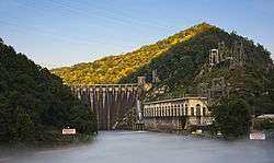 Cheoah Hydroelectric Development |
May 21, 2004 (#04000464) |
1512 Tapoca Rd., NC 129 35°27′00″N 83°56′10″W |
Robbinsville | Extends into Swain County. |
| 2 | Fontana Hydroelectric Project | .jpg) Fontana Hydroelectric Project |
August 11, 2017 (#100001462) |
1011 Fontana Dam Rd. 35°27′09″N 83°48′18″W |
Topton | |
| 3 | Charles Noden George House |  Charles Noden George House |
April 5, 1984 (#84002314) |
Off US 129 35°16′58″N 83°42′04″W |
Topton | |
| 4 | Graham County Courthouse |  Graham County Courthouse |
August 28, 2007 (#07000883) |
12 N. Main St. 35°19′21″N 83°48′25″W |
Robbinsville | |
| 5 | Santeetlah Hydroelectric Development | 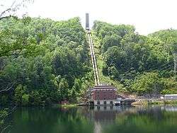 Santeetlah Hydroelectric Development |
May 21, 2004 (#04000466) |
Dam-Hwy NC 1247, Powerhouse-1277 Farley Branch Rd. 35°23′49″N 83°52′21″W |
Robbinsville | |
| 6 | Snowbird Mountain Lodge | September 2, 1993 (#93000885) |
275 Santeetlah Rd. 35°20′31″N 83°53′29″W |
Robbinsville | ||
| 7 | Tapoco Lodge Historic District | .jpg) Tapoco Lodge Historic District |
May 21, 2004 (#04000465) |
14981 Tapoco Rd. 35°26′31″N 83°56′19″W |
Robbinsville |
See also
| Wikimedia Commons has media related to National Register of Historic Places in Graham County, North Carolina. |
References
- The latitude and longitude information provided in this table was derived originally from the National Register Information System, which has been found to be fairly accurate for about 99% of listings. Some locations in this table may have been corrected to current GPS standards.
- "National Register of Historic Places: Weekly List Actions". National Park Service, United States Department of the Interior. Retrieved on June 26, 2020.
- Numbers represent an ordering by significant words. Various colorings, defined here, differentiate National Historic Landmarks and historic districts from other NRHP buildings, structures, sites or objects.
- The eight-digit number below each date is the number assigned to each location in the National Register Information System database, which can be viewed by clicking the number.

| Topics | |
|---|---|
| Lists by state |
|
| Lists by insular areas | |
| Lists by associated state | |
| Other areas | |
| Related | |
| |
Municipalities and communities of Graham County, North Carolina, United States | ||
|---|---|---|
| Towns | | |
| Unincorporated community | ||
| Indian reservation | ||
| Footnotes | ‡This populated place also has portions in an adjacent county or counties | |
This article is issued from Wikipedia. The text is licensed under Creative Commons - Attribution - Sharealike. Additional terms may apply for the media files.