National Register of Historic Places listings in Wilkes County, North Carolina
This list includes properties and districts listed on the National Register of Historic Places in Wilkes County, North Carolina. Click the "Map of all coordinates" link to the right to view an online map of all properties and districts with latitude and longitude coordinates in the table below.[1]
Current listings
- This National Park Service list is complete through NPS recent listings posted June 19, 2020.[2]
| [3] | Name on the Register[4] | Image | Date listed[5] | Location | City or town | Description |
|---|---|---|---|---|---|---|
| 1 | Brown-Cowles House and Cowles Law Office | 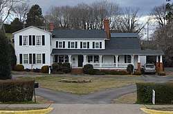 Brown-Cowles House and Cowles Law Office |
August 24, 1982 (#82003522) |
200 and 106 E. Main St. 36°08′58″N 81°09′02″W |
Wilkesboro | |
| 2 | Claymont Hill |  Claymont Hill |
September 12, 1985 (#85002369) |
Western side of SR 2303 along Ronda-Clingman Rd. 36°12′39″N 80°55′40″W |
Ronda | |
| 3 | Robert Cleveland Log House | 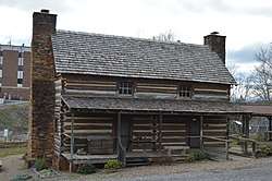 Robert Cleveland Log House |
February 1, 1972 (#72001003) |
Wilkes Heritage Museum, 100 E. Main St 36°08′58″N 81°09′10″W |
Wilkesboro | Relocated from near Pulear to near the Old Wilkes County Jail in downtown Wilkesboro in 1986.[6] |
| 4 | Downtown Main Street Historic District |  Downtown Main Street Historic District |
May 9, 2003 (#03000392) |
Roughly the 800 and 900 blocks of Main St. 36°09′34″N 81°08′47″W |
North Wilkesboro | |
| 5 | Downtown Wilkesboro Historic District | 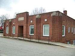 Downtown Wilkesboro Historic District |
April 30, 2009 (#09000290) |
Bounded roughly by Cowles and Corporation Sts., Henderson Dr., and Woodland Boulevard 36°08′54″N 81°09′02″W |
Wilkesboro | |
| 6 | Elkin Creek Mill | April 29, 1982 (#82003521) |
SR 2045 36°16′40″N 80°52′29″W |
West Elkin | ||
| 7 | Federal Building | 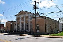 Federal Building |
August 24, 1982 (#82003523) |
201 W. Main St. 36°08′47″N 81°09′32″W |
Wilkesboro | |
| 8 | J. T. Ferguson Store |  J. T. Ferguson Store |
August 24, 1982 (#82003524) |
11 E. Main St. 36°08′53″N 81°09′04″W |
Wilkesboro | |
| 9 | Thomas B. Finley House | 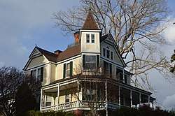 Thomas B. Finley House |
May 15, 2008 (#08000415) |
1014 E St. 36°09′42″N 81°09′03″W |
North Wilkesboro | |
| 10 | Thomas B. Finley Law Office | 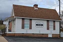 Thomas B. Finley Law Office |
August 24, 1982 (#82003525) |
Broad and North Sts. 36°08′56″N 81°09′04″W |
Wilkesboro | |
| 11 | J. L. Hemphill House | August 24, 1982 (#82003526) |
203 N. Brook St. 36°08′49″N 81°09′53″W |
Wilkesboro | ||
| 12 | Holbrook Farm |  Holbrook Farm |
November 29, 1978 (#78001985) |
West of Traphill on SR 1743 36°20′35″N 81°03′26″W |
Traphill | |
| 13 | Benjamin Hubbard House | January 29, 2009 (#08001390) |
Northern side of U.S. Route 18, 1 mile east of NC 1106 36°05′13″N 81°12′22″W |
Moravian Falls | ||
| 14 | Johnson-Hubbard House |  Johnson-Hubbard House |
August 24, 1982 (#82003527) |
113 E. Main St. 36°08′54″N 81°09′03″W |
Wilkesboro | |
| 15 | Lincoln Heights School | September 11, 2018 (#100002932) |
197 Lincoln Heights Rd. 36°08′54″N 81°07′46″W |
Wilkesboro | ||
| 16 | Old Wilkes County Jail |  Old Wilkes County Jail |
February 18, 1971 (#71000628) |
N. Bridge St. 36°08′56″N 81°09′09″W |
Wilkesboro | |
| 17 | St. Paul's Episcopal Church and Cemetery | 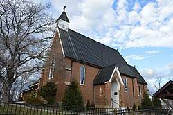 St. Paul's Episcopal Church and Cemetery |
October 19, 1982 (#82001308) |
Cowles St. between Woodland Boulevard and West St. 36°08′57″N 81°09′18″W |
Wilkesboro | |
| 18 | Southern Railway Depot |  Southern Railway Depot |
September 10, 2004 (#04000965) |
Junction of 9th St. and CBD Loop 36°09′31″N 81°08′45″W |
North Wilkesboro | |
| 19 | Traphill Historic District | May 22, 1980 (#80002905) |
SR 1002 and SR 1749 36°20′48″N 81°01′26″W |
Traphill | ||
| 20 | Wilkes County Courthouse | 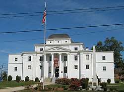 Wilkes County Courthouse |
May 10, 1979 (#79001764) |
E. Main St. between Bridge and Broad Sts. 36°08′55″N 81°09′07″W |
Wilkesboro | Now the Wilkes County Heritage Museum |
| 21 | Wilkes Hosiery Mills |  Wilkes Hosiery Mills |
April 30, 2008 (#08000369) |
407 F. St. 36°09′56″N 81°08′32″W |
North Wilkesboro | |
| 22 | Wilkesboro Presbyterian Church | 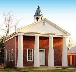 Wilkesboro Presbyterian Church |
August 24, 1982 (#82003528) |
205 E. Main St. 36°08′54″N 81°08′59″W |
Wilkesboro | |
| 23 | Wilkesboro-Smithey Hotel |  Wilkesboro-Smithey Hotel |
August 24, 1982 (#82003529) |
Broad and E. Main Sts. 36°08′55″N 81°09′04″W |
Wilkesboro |
Former listing
| [3] | Name on the Register | Image | Date listed | Date removed | Location | City or town | Summary |
|---|---|---|---|---|---|---|---|
| 1 | Montfort Stokes House | 1972 (#72001537) | Unknown | SR 1144, W of SR 1143 |
Wilkesboro | Destroyed by fire.[7] |
See also
| Wikimedia Commons has media related to National Register of Historic Places in Wilkes County, North Carolina. |
References
- The latitude and longitude information provided in this table was derived originally from the National Register Information System, which has been found to be fairly accurate for about 99% of listings. Some locations in this table may have been corrected to current GPS standards.
- "National Register of Historic Places: Weekly List Actions". National Park Service, United States Department of the Interior. Retrieved on June 19, 2020.
- Numbers represent an ordering by significant words. Various colorings, defined here, differentiate National Historic Landmarks and historic districts from other NRHP buildings, structures, sites or objects.
- "National Register Information System". National Register of Historic Places. National Park Service. April 24, 2008.
- The eight-digit number below each date is the number assigned to each location in the National Register Information System database, which can be viewed by clicking the number.
- Capt. Cleveland’s story told: New sign near log house dedicated Saturday, Wilkes Journal-Patriot, December 15, 2014

| Topics | |
|---|---|
| Lists by state |
|
| Lists by insular areas | |
| Lists by associated state | |
| Other areas | |
| Related | |
| |
Municipalities and communities of Wilkes County, North Carolina, United States | ||
|---|---|---|
| Towns | | |
| Townships |
| |
| CDPs | ||
| Unincorporated communities | ||
| Footnotes | ‡This populated place also has portions in an adjacent county or counties | |
This article is issued from Wikipedia. The text is licensed under Creative Commons - Attribution - Sharealike. Additional terms may apply for the media files.