National Register of Historic Places listings in Caldwell County, North Carolina
This list includes properties and districts listed on the National Register of Historic Places in Caldwell County, North Carolina. Click the "Map of all coordinates" link to the right to view an online map of all properties and districts with latitude and longitude coordinates in the table below.[1]

Current listings
- This National Park Service list is complete through NPS recent listings posted June 19, 2020.[2]
| [3] | Name on the Register[4] | Image | Date listed[5] | Location | City or town | Description |
|---|---|---|---|---|---|---|
| 1 | J.M. Bernhardt Planing Mill and Box Factory-Steele Cotton Mill | September 18, 2017 (#100001629) |
1201 Steele St. 35°54′39″N 81°32′44″W |
Lenoir | ||
| 2 | Caldwell County Courthouse |  Caldwell County Courthouse |
May 10, 1979 (#79001687) |
Main St. 35°54′55″N 81°32′24″W |
Lenoir | |
| 3 | Carolina and Northwestern Railway Freight Station | August 29, 2019 (#100004319) |
1407 College Ave. SW 35°54′31″N 81°32′51″W |
Lenoir | ||
| 4 | Clover Hill | .jpg) Clover Hill |
May 25, 1973 (#73001301) |
E of Patterson off NC 268 on SR 1514 35°59′41″N 81°31′40″W |
Patterson | |
| 5 | Dula-Horton Cemetery |  Dula-Horton Cemetery |
September 2, 2004 (#04000941) |
End of an 0.25 mile Ln, off S side of NC 268, 1.4 miles E of jct. with Grandin Rd. 36°03′45″N 81°24′56″W |
Grandin | |
| 6 | Fort Defiance | 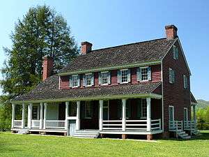 Fort Defiance |
September 15, 1970 (#70000444) |
N of Lenoir on NC 268 36°01′01″N 81°29′42″W |
Lenoir | Plantation house that was home of William Lenoir (general) |
| 7 | The Fountain | September 2, 2004 (#04000942) |
1677 NC 268 35°59′57″N 81°32′19″W |
Yadkin Valley | ||
| 8 | Green Park Historic District |  Green Park Historic District |
August 19, 1994 (#94001020) |
Jct. of US 321 and Green Hill and Rock Rds. 36°07′17″N 81°39′38″W |
Blowing Rock | |
| 9 | William Hagler House | December 28, 1982 (#82001282) |
N of Grandin on SR 1510 36°03′31″N 81°24′29″W |
Grandin | ||
| 10 | Hudson Cotton Manufacturing Company |  Hudson Cotton Manufacturing Company |
August 28, 2013 (#13000636) |
447 Main St. 35°51′01″N 81°29′44″W |
Hudson | |
| 11 | Lenoir Cotton Mill-Blue Bell Inc. Plant | September 18, 2017 (#100001630) |
1241 College Ave. 35°54′33″N 81°32′49″W |
Lenoir | ||
| 12 | Lenoir Downtown Historic District | 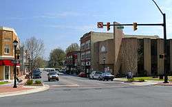 Lenoir Downtown Historic District |
September 5, 2007 (#07000905) |
Roughly bounded by Ashe Ave., Mulberry St., Harper Ave., Church St., and Boundary St.; 915-1011 West Ave. & 122 Boundary St. 35°54′56″N 81°32′17″W |
Lenoir | Second set of addresses is from a boundary increase on 5/8/13 |
| 13 | Lenoir Grammar School | 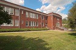 Lenoir Grammar School |
April 19, 2006 (#06000290) |
506 Harper St. 35°54′59″N 81°32′09″W |
Lenoir | |
| 14 | Lenoir High School | 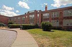 Lenoir High School |
August 2, 1990 (#90001146) |
100 Willow St. 35°54′41″N 81°32′37″W |
Lenoir | |
| 15 | Walter James Lenoir House | September 2, 2004 (#04000938) |
NC 268, 0.3 miles E of jct. with NC 1513 36°00′56″N 81°30′12″W |
Yadkin Valley | ||
| 16 | Mariah's Chapel |  Mariah's Chapel |
September 2, 2004 (#04000939) |
NC 1552, 0.4 miles SE of jct with NC 268 36°03′33″N 81°25′47″W |
Grandin | |
| 17 | Mary's Grove | 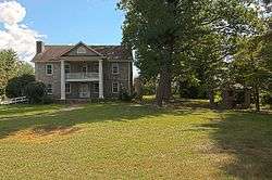 Mary's Grove |
April 25, 2001 (#01000418) |
2121 Harper Ave., SW 35°53′54″N 81°33′56″W |
Lenoir | |
| 18 | Patterson School Historic District | December 22, 2004 (#04001386) |
Along both sides of NC 268 at the jct. with NC 1504 36°01′17″N 81°31′18″W |
Legerwood | ||
| 19 | Edgar Allan Poe House | May 18, 2001 (#01000514) |
506 Main St. NW 35°55′05″N 81°32′28″W |
Lenoir | ||
| 20 | Riverside | September 2, 2004 (#04000940) |
SW side NC 1552, 0.3 miles SE of jct with NC 268 36°03′22″N 81°25′55″W |
Grandin |
See also
| Wikimedia Commons has media related to National Register of Historic Places in Caldwell County, North Carolina. |
References
- The latitude and longitude information provided in this table was derived originally from the National Register Information System, which has been found to be fairly accurate for about 99% of listings. Some locations in this table may have been corrected to current GPS standards.
- "National Register of Historic Places: Weekly List Actions". National Park Service, United States Department of the Interior. Retrieved on June 19, 2020.
- Numbers represent an ordering by significant words. Various colorings, defined here, differentiate National Historic Landmarks and historic districts from other NRHP buildings, structures, sites or objects.
- "National Register Information System". National Register of Historic Places. National Park Service. April 24, 2008.
- The eight-digit number below each date is the number assigned to each location in the National Register Information System database, which can be viewed by clicking the number.

| Topics | |
|---|---|
| Lists by state |
|
| Lists by insular areas | |
| Lists by associated state | |
| Other areas | |
| Related | |
| |
Municipalities and communities of Caldwell County, North Carolina, United States | ||
|---|---|---|
| Cities | Caldwell County map | |
| Towns | ||
| Village | ||
| CDP | ||
| Unincorporated communities | ||
| Footnotes | ‡This populated place also has portions in an adjacent county or counties | |
This article is issued from Wikipedia. The text is licensed under Creative Commons - Attribution - Sharealike. Additional terms may apply for the media files.