National Register of Historic Places listings in Washington County, North Carolina
This list includes properties and districts listed on the National Register of Historic Places in Washington County, North Carolina. Click the "Map of all coordinates" link to the right to view a Google map of all properties and districts with latitude and longitude coordinates in the table below.[1]

Current listings
- This National Park Service list is complete through NPS recent listings posted June 26, 2020.[2]
| [3] | Name on the Register | Image | Date listed[4] | Location | City or town | Description |
|---|---|---|---|---|---|---|
| 1 | Belgrade and St. David's Church | Belgrade and St. David's Church |
January 26, 1978 (#78001983) |
E of Creswell St. 35°52′21″N 76°22′54″W |
Creswell | |
| 2 | Creswell Historic District |  Creswell Historic District |
October 10, 2002 (#02001112) |
Roughly bounded by 208 E. Main St. and 310 W. Main St., 302-304 S. Sixth Sts., and 219 N. Sixth St. 35°52′11″N 76°23′38″W |
Creswell | |
| 3 | Davenport House | September 5, 2007 (#07000932) |
NC 1143 (Mount Tabor Rd.) and NC 1146 (Mount Tabor Road-Backwoods) 35°52′15″N 76°26′59″W |
Creswell | ||
| 4 | Garrett's Island House | February 2, 2001 (#01000047) |
1445 Garrett's Island Rd. 35°50′48″N 76°42′22″W |
Plymouth | ||
| 5 | Latham House | 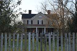 Latham House |
December 12, 1976 (#76001348) |
311 E. Main St. 35°52′02″N 76°44′44″W |
Plymouth | |
| 6 | Perry-Spruill House |  Perry-Spruill House |
April 25, 1985 (#85000905) |
326 Washington St. 35°51′50″N 76°44′57″W |
Plymouth | |
| 7 | Plymouth Historic District | 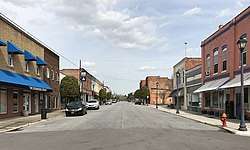 Plymouth Historic District |
January 16, 1991 (#90002140) |
Roughly bounded by Monroe St., the Roanoke River, Latham La., Third St., Washington St. and the Norfolk Southern RR tracks 35°51′51″N 76°45′00″W |
Plymouth | |
| 8 | Rehoboth Methodist Church | May 13, 1976 (#76001349) |
East of Skinnersville on U.S. Route 64 35°56′22″N 76°31′23″W |
Skinnersville | ||
| 9 | Somerset Place State Historic Site | 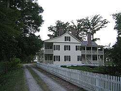 Somerset Place State Historic Site |
February 26, 1970 (#70000481) |
In Pettigrew State Park 35°47′15″N 76°24′20″W |
Creswell | |
| 10 | Washington County Courthouse | 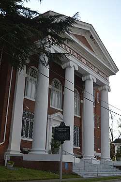 Washington County Courthouse |
May 10, 1979 (#79001761) |
Main and Adams Sts. 35°52′00″N 76°44′57″W |
Plymouth |
See also
| Wikimedia Commons has media related to National Register of Historic Places in Washington County, North Carolina. |
References
- The latitude and longitude information provided in this table was derived originally from the National Register Information System, which has been found to be fairly accurate for about 99% of listings. Some locations in this table may have been corrected to current GPS standards.
- "National Register of Historic Places: Weekly List Actions". National Park Service, United States Department of the Interior. Retrieved on June 26, 2020.
- Numbers represent an ordering by significant words. Various colorings, defined here, differentiate National Historic Landmarks and historic districts from other NRHP buildings, structures, sites or objects.
- The eight-digit number below each date is the number assigned to each location in the National Register Information System database, which can be viewed by clicking the number.

| Topics | |
|---|---|
| Lists by state |
|
| Lists by insular areas | |
| Lists by associated state | |
| Other areas | |
| Related | |
| |
Municipalities and communities of Washington County, North Carolina, United States | ||
|---|---|---|
| Towns | | |
| Unincorporated communities |
| |
This article is issued from Wikipedia. The text is licensed under Creative Commons - Attribution - Sharealike. Additional terms may apply for the media files.