List of National Historic Landmarks in North Carolina
This is a List of National Historic Landmarks in North Carolina.
North Carolina has 39 National Historic Landmarks:
| [1] | Landmark name | Image | Date designated[2] | Location | County | Description |
|---|---|---|---|---|---|---|
| 1 | Bentonville Battlefield |  Bentonville Battlefield |
June 19, 1996 (#70000460) |
Bentonville and Newton Grove 35°18′23″N 78°19′26″W |
Johnston | Site of Battle of Bentonville |
| 2 | Bethabara | %2C_Old_Town_(Forsyth_County%2C_North_Carolina).jpg) Bethabara |
January 20, 1999 (#78001948) |
Winston-Salem 36°09′16″N 80°17′55″W |
Forsyth | Area of 1753 Moravian settlement |
| 3 | Bethania Historic District |  Bethania Historic District |
August 7, 2001 (#76001321) |
Bethania 36°11′02″N 80°20′13″W |
Forsyth | |
| 4 | Biltmore Estate | 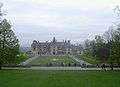 Biltmore Estate |
May 23, 1963 (#66000586) |
Asheville 35.53965°N 82.55095°W 35°32′23″N 82°33′03″W |
Buncombe | |
| 5 | W. T. Blackwell and Company Tobacco Factory |  W. T. Blackwell and Company Tobacco Factory |
December 22, 1977 (#74001346) |
Durham 35°59′44″N 78°54′14″W |
Durham | Also known as Bull Durham Tobacco Factory. |
| 6 | Blandwood | 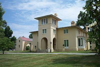 Blandwood |
June 7, 1988 (#70000455) |
Greensboro 36°04′13″N 79°47′44″W |
Guilford | Former home of progressive North Carolina Governor John Motley Morehead, designed by New York architect Alexander Jackson Davis in the Italian Tuscan style. |
| 7 | Cape Hatteras Light Station | 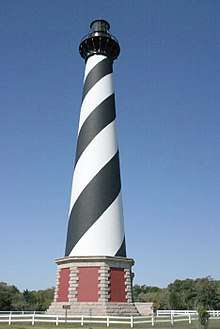 Cape Hatteras Light Station |
August 5, 1998 (#78000266) |
Buxton 35°15′02″N 75°31′44″W |
Dare | At 208 feet (63 m) tall, tallest lighthouse in the United States. |
| 8 | Capitol (North Carolina) |  Capitol (North Carolina) |
November 6, 1973 (#70000476) |
Raleigh 35°46′52″N 78°38′20″W |
Wake | Capitol building, part of Capitol Area Historic District. |
| 9 | Chowan County Courthouse | .jpg) Chowan County Courthouse |
April 15, 1970 (#70000447) |
Edenton 36°03′28″N 76°36′29″W |
Chowan | |
| 10 | Christ Episcopal Church |  Christ Episcopal Church |
December 23, 1987 (#87002597) |
Raleigh 35°46′52″N 78°38′16″W |
Wake | Perhaps earliest Gothic architecture church in the South, designed in 1846 by Richard Upjohn |
| 11 | Connemara, The Carl Sandburg Farm |  Connemara, The Carl Sandburg Farm |
May 23, 1968 (#68000013) |
Flat Rock 35°16′04″N 82°27′06″W |
Henderson | |
| 12 | Cooleemee | .png) Cooleemee |
June 2, 1978 (#73001334) |
Mocksville 35°51′12″N 80°24′36″W |
Davie | Innovative Piedmont plantation house influenced by designs of architect William H. Ranlett. |
| 13 | Coolmore | .jpg) Coolmore |
June 2, 1978 (#71000581) |
Tarboro 35°55′29″N 77°35′46″W |
Edgecombe | Plantation |
| 14 | Cupola House | .jpg) Cupola House |
April 15, 1970 (#70000889) |
Edenton 36°03′28″N 76°36′33″W |
Chowan | A house with a cupola |
| 15 | Josephus Daniels House |  Josephus Daniels House |
December 8, 1976 (#76001342) |
Raleigh 35°47′56″N 78°38′51″W |
Wake | Home of Josephus Daniels |
| 16 | Duke Homestead and Tobacco Factory |  Duke Homestead and Tobacco Factory |
November 13, 1966 (#66000590) |
Durham 36°02′06″N 78°55′16″W |
Durham | Homestead and factory of Washington Duke |
| 17 | Fort Fisher | 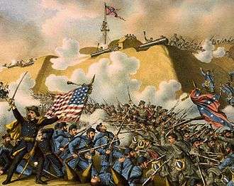 Fort Fisher |
November 5, 1961 (#66000595) |
Wilmington 33°58′18″N 77°55′10″W |
New Hanover | A fort |
| 18 | Guilford Court House Battlefield | 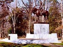 Guilford Court House Battlefield |
January 3, 2001 (#66000069) |
Greensboro 36°07′53″N 79°50′47″W |
Guilford | Partially preserved site of American Revolutionary War's Battle of Guilford Court House |
| 19 | Hardaway Site | June 21, 1990 (#84002529) |
Badin 35°24′38″N 80°06′53″W |
Stanly | An archaeological site | |
| 20 | Hayes Plantation |  Hayes Plantation |
November 7, 1973 (#74001341) |
Edenton 36°02′53″N 76°36′08″W |
Chowan | A plantation |
| 21 | Hinton Rowan Helper House | 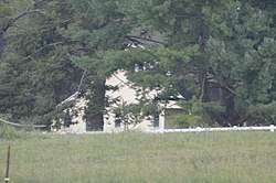 Hinton Rowan Helper House |
November 7, 1973 (#73001336) |
Mocksville 35°54′18″N 80°36′17″W |
Davie | Former home of abolitionist and author of nationally influential publication "The Impending Crisis of the South". |
| 22 | Market House | 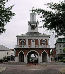 Market House |
November 7, 1973 (#70000451) |
Fayetteville 35°03′09″N 78°52′42″W |
Cumberland | Market below, town hall above |
| 23 | MONITOR | 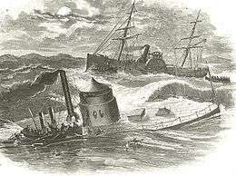 MONITOR |
June 23, 1986 (#74002299) |
Cape Hatteras 35°00′06″N 75°24′23″W |
Dare | USS Monitor shipwreck (ironclad). |
| 24 | Pauli Murray Family Home | 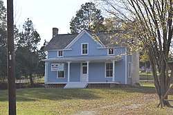 Pauli Murray Family Home |
December 23, 2016 (#100000866) |
Durham 35°59′34″N 78°54′59″W |
Durham | Now the Pauli Murray Center. |
| 25 | Nash-Hooper House |  Nash-Hooper House |
November 11, 1971 (#71000610) |
Hillsborough 36°04′37″N 79°06′01″W |
Orange | NRHP 71000610 |
| 26 | North Carolina Mutual Life Insurance Company Building |  North Carolina Mutual Life Insurance Company Building |
May 15, 1975 (#75001258) |
Durham 35°59′45″N 78°54′03″W |
Durham | 1921 commercial building; second headquarters of a major black-owned insurance company. |
| 27 | NORTH CAROLINA |  NORTH CAROLINA |
January 14, 1986 (#82004893) |
Wilmington 34°14′06″N 77°56′34″W |
New Hanover | NRHP 82004893. USS North Carolina (battleship). |
| 28 | Old East |  Old East |
December 21, 1965 (#66000596) |
Chapel Hill 35°54′38″N 79°03′03″W |
Orange | First building of first state university in the United States, built in 1795 |
| 29 | Old Salem Historic District |  Old Salem Historic District |
November 13, 1966 (#66000591) |
Winston-Salem 36°05′12″N 80°14′31″W |
Forsyth | Early Moravian settlement, now a museum |
| 30 | Palmer-Marsh House | .jpg) Palmer-Marsh House |
April 15, 1970 (#70000439) |
Bath 35°28′30″N 76°48′51″W |
Beaufort | |
| 31 | Pinehurst Historic District | _001.jpg) Pinehurst Historic District |
June 19, 1996 (#73001361) |
Pinehurst 35°11′42″N 79°28′23″W |
Moore | Resort community designed by Frederick Law Olmsted; also includes Pinehurst Resort |
| 32 | Playmakers Theatre |  Playmakers Theatre |
November 7, 1973 (#71000605) |
Chapel Hill 35°54′17″N 79°03′02″W |
Orange | Academic building in the Greek Revival style by New York architect Alexander Jackson Davis. |
| 33 | Reed Gold Mine | 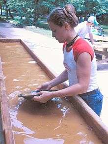 Reed Gold Mine |
May 23, 1966 (#66000587) |
Concord 35°17′08″N 80°28′12″W |
Cabarrus | Site of first gold discovery in United States |
| 34 | Salem Tavern | .jpg) Salem Tavern |
January 29, 1964 (#66000592) |
Winston-Salem 36°05′07″N 80°14′30″W |
Forsyth | Vernacular structure erected in the eighteenth century that served as a social center of the North Carolina Piedmont. |
| 35 | Single Brothers' House | .jpg) Single Brothers' House |
April 15, 1970 (#70000454) |
Winston-Salem 36°05′15″N 80°14′32″W |
Forsyth | Early vernacular structure that exemplifies the central European architectural traditions of the Moravians. |
| 36 | Town Creek Indian Mound | 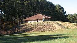 Town Creek Indian Mound |
July 19, 1964 (#66000594) |
Mount Gilead 35°10′58″N 79°55′46″W |
Montgomery | Archaeological site |
| 37 | Union Tavern | .jpg) Union Tavern |
May 15, 1975 (#75001245) |
Milton 36°32′12″N 79°12′24″W |
Caswell | Early nineteenth century vernacular structure with strong associations with influential freedman cabinetmaker Thomas Day. |
| 38 | Thomas Wolfe House | 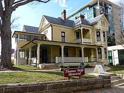 Thomas Wolfe House |
November 11, 1971 (#71000572) |
Asheville 35°35′45″N 82°32′43″W |
Buncombe | |
| 39 | Wright Brothers National Memorial Visitor Center |  Wright Brothers National Memorial Visitor Center |
January 3, 2001 (#66000071) |
Kill Devil Hills 36°01′14″N 75°40′03″W |
Dare |
See also
| Wikimedia Commons has media related to National Historic Landmarks in North Carolina. |
- National Register of Historic Places listings in North Carolina
- List of National Historic Landmarks by state
References
- Numbers represent an ordering by significant words. Various colorings, defined here, differentiate National Historic Landmarks and historic districts from other NRHP buildings, structures, sites or objects.
- The eight-digit number below each date is the number assigned to each location in the National Register Information System database, which can be viewed by clicking the number.
External links
- "National Register Information System". National Register of Historic Places. National Park Service. July 9, 2010.
| Topics | |
|---|---|
| Lists by state |
|
| Lists by insular areas | |
| Lists by associated state | |
| Other areas | |
| Related | |
| |


This article is issued from Wikipedia. The text is licensed under Creative Commons - Attribution - Sharealike. Additional terms may apply for the media files.