National Register of Historic Places listings in Davie County, North Carolina
This list includes properties and districts listed on the National Register of Historic Places in Davie County, North Carolina. Click the "Map of all coordinates" link to the right to view a Google map of all properties and districts with latitude and longitude coordinates in the table below.[1]
Current listings
- This National Park Service list is complete through NPS recent listings posted June 19, 2020.[2]
| [3] | Name on the Register | Image | Date listed[4] | Location | City or town | Description |
|---|---|---|---|---|---|---|
| 1 | George E. Barnhardt House | May 4, 2009 (#09000289) |
291 Hartley Rd. 35°49′19″N 80°29′02″W |
Mocksville | ||
| 2 | Boxwood Lodge | June 2, 1995 (#95000673) |
132 Becktown Rd. 35°48′46″N 80°30′45″W |
Mocksville | ||
| 3 | Cana Store and Post Office | October 5, 2001 (#01001073) |
NC 1411, 0.2 miles N of NC 1406 35°58′24″N 80°34′38″W |
Mocksville | ||
| 4 | Center Arbor |  Center Arbor |
September 3, 1991 (#91001168) |
Jct. of US 64 and NC 1150, NW corner 35°54′42″N 80°37′14″W |
Center | |
| 5 | Jesse Clement House | 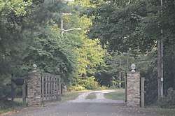 Jesse Clement House |
April 17, 1980 (#80002823) |
Maple Ave. 35°53′17″N 80°33′33″W |
Mocksville | |
| 6 | Cooleemee | _crop.png) Cooleemee |
March 20, 1973 (#73001334) |
Terminus of SR 1812 35°51′12″N 80°24′36″W |
Mocksville | |
| 7 | Cooleemee Mill Town Historic District | September 24, 2014 (#14000704) |
Roughly bounded by Marginal, Hickory, Center & Holt Sts., Neely & Pine Ridge Rds., S. Yadkin R. 35°48′26″N 80°33′22″W |
Cooleemee | ||
| 8 | Davie County Courthouse | 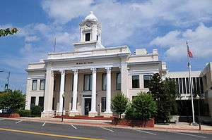 Davie County Courthouse |
May 10, 1979 (#79001702) |
Courthouse Sq. 35°53′37″N 80°33′41″W |
Mocksville | |
| 9 | Davie County Jail | 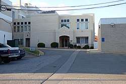 Davie County Jail |
April 24, 1973 (#73001335) |
20 S. Main St. 35°53′35″N 80°33′39″W |
Mocksville | |
| 10 | Downtown Mocksville Historic District | 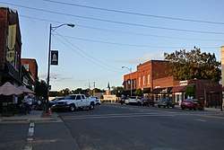 Downtown Mocksville Historic District |
June 1, 1990 (#90000821) |
Roughly Main St. from Water to Gaither Sts., including Town Square 35°53′39″N 80°33′43″W |
Mocksville | |
| 11 | Farmington Historic District | December 27, 2010 (#10001059) |
Farmington Rd., NC 801 North, Cemetery Rd., Roland Rd., and Hartman Lane 36°00′57″N 80°31′57″W |
Farmington | ||
| 12 | Foard-Tatum House | May 26, 1994 (#94000530) |
At end of NC 1101 35°47′35″N 80°31′21″W |
Cooleemee | ||
| 13 | Fulton United Methodist Church | November 15, 1979 (#79001701) |
S of Advance off NC 801 35°53′09″N 80°25′08″W |
Advance | ||
| 14 | Hinton Rowan Helper House | 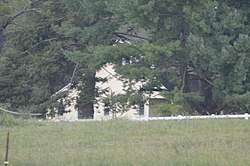 Hinton Rowan Helper House |
November 7, 1973 (#73001336) |
U.S. 64 off I-40 35°54′25″N 80°36′17″W |
Mocksville | |
| 15 | Hodges Business College | August 16, 2000 (#00000990) |
NC 1819, 0.15 miles SE of jct. with NC 801 35°50′20″N 80°30′14″W |
Mocksville | ||
| 16 | McGuire-Setzer House | September 4, 1992 (#92001152) |
NC 1139 0.2 miles S of Mocksville town limits 35°52′49″N 80°34′15″W |
Mocksville | ||
| 17 | North Main Street Historic District | 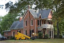 North Main Street Historic District |
June 1, 1990 (#90000822) |
Roughly Main St. from Church St. to Mocksville city limits 35°54′04″N 80°33′17″W |
Mocksville | |
| 18 | Salisbury Street Historic District | 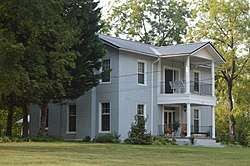 Salisbury Street Historic District |
June 1, 1990 (#90000819) |
Roughly Salisbury St. from Kelly St. to Lexington Rd. 35°53′23″N 80°33′54″W |
Mocksville | |
| 19 | John Edward Belle Shutt House and Outbuildings | May 16, 1996 (#96000567) |
2177 NC 801, S 35°56′09″N 80°24′33″W |
Advance | ||
| 20 | Win-Mock Farm Dairy |  Win-Mock Farm Dairy |
December 27, 2010 (#10001057) |
168 E. Kinderton Way 36°00′45″N 80°25′25″W |
Bermuda Run |
See also
| Wikimedia Commons has media related to National Register of Historic Places in Davie County, North Carolina. |
References
- The latitude and longitude information provided in this table was derived originally from the National Register Information System, which has been found to be fairly accurate for about 99% of listings. Some locations in this table may have been corrected to current GPS standards.
- "National Register of Historic Places: Weekly List Actions". National Park Service, United States Department of the Interior. Retrieved on June 19, 2020.
- Numbers represent an ordering by significant words. Various colorings, defined here, differentiate National Historic Landmarks and historic districts from other NRHP buildings, structures, sites or objects.
- The eight-digit number below each date is the number assigned to each location in the National Register Information System database, which can be viewed by clicking the number.

| Topics | |
|---|---|
| Lists by state |
|
| Lists by insular areas | |
| Lists by associated state | |
| Other areas | |
| Related | |
| |
Municipalities and communities of Davie County, North Carolina, United States | ||
|---|---|---|
| Towns | Davie County map | |
| CDP | ||
| Unincorporated communities | ||
This article is issued from Wikipedia. The text is licensed under Creative Commons - Attribution - Sharealike. Additional terms may apply for the media files.