National Register of Historic Places listings in Pitt County, North Carolina
This list includes properties and districts listed on the National Register of Historic Places in Pitt County, North Carolina. Click the "Map of all coordinates" link to the right to view an online map of all properties and districts with latitude and longitude coordinates in the table below.[1]
Current listings
- This National Park Service list is complete through NPS recent listings posted June 19, 2020.[2]
| [3] | Name on the Register[4] | Image | Date listed[5] | Location | City or town | Description |
|---|---|---|---|---|---|---|
| 1 | Ayden Historic District | August 26, 1994 (#94001026) |
Roughly bounded by Verna St., Peachtree St., E. College St. and Planters St. 35°28′09″N 77°25′13″W |
Ayden | ||
| 2 | Chicod Creek Wreck | August 24, 2018 (#100002805) |
Address restricted[6] |
Grimesland vicinity | ||
| 3 | College View Historic District |  College View Historic District |
March 19, 1992 (#92000181) |
Roughly bounded by Holly, Eastern, E. First and E. Fifth Sts. 35°36′37″N 77°21′54″W |
Greenville | |
| 4 | Cox-Ange House |  Cox-Ange House |
October 6, 2000 (#00001181) |
113 N. Church St. 35°31′43″N 77°24′04″W |
Winterville | |
| 5 | Dickinson Avenue Historic District |  Dickinson Avenue Historic District |
March 1, 2007 (#07000092) |
600-900 blocks Dickinson Ave., one block of side streets, including W. Eighth, Flicklien, S. Pitt, Clark Sts., Atlantic, Albermarle 35°36′27″N 77°22′47″W |
Greenville | |
| 6 | Dupree-Moore Farm | August 28, 2012 (#12000579) |
3901 Buck Moore Rd. 35°43′47″N 77°32′25″W |
Falkland vicinity | ||
| 7 | Falkland Historic District | October 3, 2012 (#12000833) |
Roughly Crisp, N. Main, & S. Main Sts., & West Ave. 35°41′56″N 77°30′51″W |
Falkland | ||
| 8 | Farmville Historic District |  Farmville Historic District |
October 21, 1993 (#93001121) |
Roughly bounded by Turnage, Pine, Jones, and Waverly Sts. 35°35′56″N 77°35′11″W |
Farmville | |
| 9 | E. B. Ficklen House | 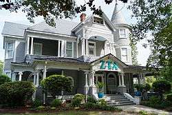 E. B. Ficklen House |
December 20, 1984 (#84000564) |
508 W. 5th St. 35°36′45″N 77°22′47″W |
Greenville | |
| 10 | James L. Fleming House | 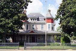 James L. Fleming House |
July 21, 1983 (#83001903) |
302 S. Greene St. 35°36′47″N 77°22′30″W |
Greenville | |
| 11 | Fountain Historic District | May 3, 2016 (#16000221) |
Roughly bounded by Smith St., Blount St., extending along Wilson St., between Church and Stamper Sts. 35°40′28″N 77°38′19″W |
Fountain | ||
| 12 | Greenville Commercial Historic District |  Greenville Commercial Historic District |
August 21, 2003 (#03000419) |
Roughly bounded by West Third, South Evans and East and West Fifth Sts. 35°36′42″N 77°22′23″W |
Greenville | |
| 13 | Greenville Tobacco Warehouse Historic District |  Greenville Tobacco Warehouse Historic District |
July 17, 1997 (#97000726) |
Roughly bounded by 12th, Clark, Ficklen, and Washington Sts. • Greenville, North Carolina Warehouse Historic District boundary increase (listed November 30, 1999, refnum 99001450): Eleventh St. near Clark St. 35°36′23″N 77°22′37″W |
Greenville | |
| 14 | Greenwreath | April 29, 1982 (#82003498) |
West of Greenville 35°36′43″N 77°24′02″W |
Greenville | ||
| 15 | Grimesland Plantation |  Grimesland Plantation |
March 31, 1971 (#71000616) |
East of Grimesland on SR 1569 35°33′22″N 77°10′02″W |
Grimesland | |
| 16 | Spencer Harris House | January 20, 2005 (#04001527) |
1287 NC 121 35°39′15″N 77°30′51″W |
Falkland | ||
| 17 | Robert Lee Humber House | 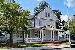 Robert Lee Humber House |
July 9, 1981 (#81000425) |
117 W. 5th St. 35°36′39″N 77°22′18″W |
Greenville | |
| 18 | Jones-Lee House |  Jones-Lee House |
November 25, 1980 (#80002894) |
805 E. Evans St. 35°36′27″N 77°22′29″W |
Greenville | |
| 19 | Kittrell-Dail House | March 24, 2000 (#00000287) |
Junction of NC 1117 and NC 1114 35°30′44″N 77°29′14″W |
Renston | ||
| 20 | Robert J. Lang Jr. House | August 23, 1990 (#90001313) |
SR 1231, 0.1 miles (0.16 km) south of the junction with SR 1200 35°37′58″N 77°40′32″W |
Fountain | ||
| 21 | William H. Long House |  William H. Long House |
April 15, 1982 (#82003499) |
200 E. 4th St. 35°26′43″N 77°22′31″W |
Greenville | |
| 22 | Benjamin May-Lewis House | June 20, 1985 (#85001337) |
US 264-A 35°36′35″N 77°38′36″W |
Farmville | ||
| 23 | Jesse R. Moye House |  Jesse R. Moye House |
October 17, 1997 (#97001220) |
408 W. Fifth St. 35°36′43″N 77°22′38″W |
Greenville | |
| 24 | Oakmont | October 15, 2001 (#01001115) |
2909 S. Memorial Dr. 35°34′59″N 77°23′45″W |
Greenville | ||
| 25 | Pitt County Courthouse |  Pitt County Courthouse |
May 10, 1979 (#79001745) |
N. 3rd St. between Washington and S. Evan St. 35°36′49″N 77°22′23″W |
Greenville | part of the North Carolina County Courthouses Thematic Resource (TR) |
| 26 | Red Banks Primitive Baptist Church |  Red Banks Primitive Baptist Church |
February 20, 2002 (#02000060) |
NC 1704, junction with NC 1725 35°34′18″N 77°20′28″W |
Bell Fork | |
| 27 | Renston Rural Historic District | December 4, 2003 (#03001236) |
Approximately 2.5 miles (4.0 km) along NC 903, roughly bounded by NC 1127 and Stokes Ln. 35°31′33″N 77°28′43″W |
Winterville | ||
| 28 | Thomas Sheppard Farm | May 18, 2000 (#00000517) |
NC 1550, near the junction of NC 1552 35°41′37″N 77°12′35″W |
Stokes | ||
| 29 | Skinnerville-Greenville Heights Historic District |  Skinnerville-Greenville Heights Historic District |
December 23, 2005 (#05001452) |
Roughly bounded by Pitt St., Martin Luther King Kr. Dr., Ward St., White St., Tyson St., Fairfax St., the Tar River 35°35′20″N 77°22′53″W |
Greenville | |
| 30 | St. John's Episcopal Church |  St. John's Episcopal Church |
December 2, 1986 (#86003268) |
SE corner of SR 1917 and SR 1753 35°22′24″N 77°21′36″W |
St. John's | |
| 31 | US Post Office | .JPG) US Post Office |
February 6, 1986 (#86000784) |
215 S. Evans St. 35°36′47″N 77°22′21″W |
Greenville |
See also
| Wikimedia Commons has media related to National Register of Historic Places in Pitt County, North Carolina. |
References
- The latitude and longitude information provided in this table was derived originally from the National Register Information System, which has been found to be fairly accurate for about 99% of listings. Some locations in this table may have been corrected to current GPS standards.
- "National Register of Historic Places: Weekly List Actions". National Park Service, United States Department of the Interior. Retrieved on June 19, 2020.
- Numbers represent an ordering by significant words. Various colorings, defined here, differentiate National Historic Landmarks and historic districts from other NRHP buildings, structures, sites or objects.
- "National Register Information System". National Register of Historic Places. National Park Service. April 24, 2008.
- The eight-digit number below each date is the number assigned to each location in the National Register Information System database, which can be viewed by clicking the number.
- Federal and state laws and practices restrict general public access to information regarding the specific location of this resource. In some cases, this is to protect archeological sites from vandalism, while in other cases it is restricted at the request of the owner. See: Knoerl, John; Miller, Diane; Shrimpton, Rebecca H. (1990), Guidelines for Restricting Information about Historic and Prehistoric Resources, National Register Bulletin, National Park Service, U.S. Department of the Interior, OCLC 20706997.

| Topics | |
|---|---|
| Lists by state |
|
| Lists by insular areas | |
| Lists by associated state | |
| Other areas | |
| Related | |
| |
Municipalities and communities of Pitt County, North Carolina, United States | ||
|---|---|---|
| City | | |
| Towns | ||
| Townships |
| |
| CDPs | ||
| Unincorporated communities | ||
| Footnotes | ‡This populated place also has portions in an adjacent county or counties | |
This article is issued from Wikipedia. The text is licensed under Creative Commons - Attribution - Sharealike. Additional terms may apply for the media files.