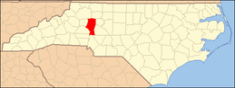
National Register of Historic Places listings in Iredell County, North Carolina
This list includes properties and districts listed on the National Register of Historic Places in Iredell County, North Carolina. Click the "Map of all coordinates" link to the right to view an online map of all properties and districts with latitude and longitude coordinates in the table below.[1]
Current listings
- This National Park Service list is complete through NPS recent listings posted June 19, 2020.[2]
| [3] | Name on the Register[4] | Image | Date listed[5] | Location | City or town | Description |
|---|---|---|---|---|---|---|
| 1 | Academy Hill Historic District |  Academy Hill Historic District |
November 24, 1980 (#80002867) |
Western Ave., Bell, Mulberry, Wise and Armfield Sts. 35°46′38″N 80°53′24″W |
Statesville | Built in 1885-1930. |
| 2 | Allison Woods |  Allison Woods |
March 9, 1995 (#95000173) |
Roughly, area east and south of US 21 surrounding the South Yadkin River, north to NC 2156 35°53′43″N 80°49′13″W |
Statesville | Built in 1926-1938 |
| 3 | Bethesda Presbyterian Church, Session House and Cemetery | December 8, 1980 (#80002855) |
SR 2359 35°43′15″N 80°48′19″W |
Houstonville | Built in 1853. | |
| 4 | Espy Watts Brawley House |  Espy Watts Brawley House |
November 24, 1980 (#80002859) |
601 William St. 35°35′57″N 80°48′29″W |
Mooresville | Built in 1904. |
| 5 | Perciphull Campbell House |  Perciphull Campbell House |
December 8, 1980 (#80002881) |
SR 1832 36°02′31″N 80°50′32″W |
Union Grove | Built c. 1820 |
| 6 | Center Street A.M.E. Zion Church |  Center Street A.M.E. Zion Church |
November 24, 1980 (#80002868) |
S. Center St. 35°46′44″N 80°53′07″W |
Statesville | Built in 1903 |
| 7 | Centre Presbyterian Church, Session House and Cemeteries |  Centre Presbyterian Church, Session House and Cemeteries |
November 24, 1980 (#80002863) |
SR 1245 35°33′07″N 80°51′17″W |
Mount Mourne | Built in 1765 (originally). Destroyed by fire. Reconstructed in 1854. |
| 8 | Coddle Creek Associate Reformed Presbyterian Church, Session House and Cemetery |  Coddle Creek Associate Reformed Presbyterian Church, Session House and Cemetery |
November 24, 1980 (#80002864) |
SR 1146 35°30′37″N 80°46′03″W |
Mount Mourne | Built in 1753. Destroyed by fire in 1838. Destroyed by fire and then reconstructed in 1884. |
| 9 | Cornelius House | November 24, 1980 (#80002860) |
SR 1378 and SR 1302 35°37′46″N 80°52′13″W |
Mooresville | Built in 1825. | |
| 10 | Daltonia |  Daltonia |
December 8, 1980 (#80002856) |
SR 2115 36°00′02″N 80°44′57″W |
Houstonville | Built in 1858. |
| 11 | Damascus Baptist Church Arbor | 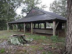 Damascus Baptist Church Arbor |
November 24, 1980 (#80002850) |
Off SR 1158 and SR 1582 35°56′04″N 80°58′43″W |
Harmony | Built in 1855. |
| 12 | Davidson House | November 24, 1980 (#80002880) |
SR 1337 35°44′55″N 80°54′57″W |
Troutman | Built in 1805, 1830. | |
| 13 | East Broad Street-Davie Avenue Historic District |  East Broad Street-Davie Avenue Historic District |
November 24, 1980 (#80002869) |
Davie Ave., Broad and Elm Sts. 35°47′17″N 80°52′58″W |
Statesville | Built in 1880-1930. |
| 14 | Ebenezer Academy, Bethany Presbyterian Church and Cemetery | 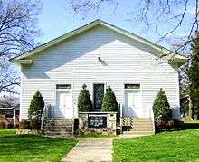 Ebenezer Academy, Bethany Presbyterian Church and Cemetery |
December 8, 1980 (#80002857) |
U.S. 21 35°51′43″N 80°50′41″W |
Houstonville | Built in 1823 (academy), 1855 (church) |
| 15 | Henry Eccles House | November 24, 1980 (#80002870) |
SR 2145 and SR 2180 35°51′08″N 80°43′39″W |
Statesville | Built in 1861. | |
| 16 | Falls-Hobbs House | June 24, 1982 (#82003471) |
SR 1303 35°37′11″N 80°53′21″W |
Statesville | Built in 1820s or 1830s | |
| 17 | Farmville Plantation | June 19, 1973 (#73001353) |
Southeast of Elmwood off US 70 on SR 2362 35°44′22″N 80°45′54″W |
Elmwood | Built in 1818. | |
| 18 | Feimster House | June 24, 1982 (#82003472) |
SR 1516 35°52′23″N 80°58′36″W |
Statesville | Built c. 1800 | |
| 19 | Fort Dobbs | 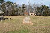 Fort Dobbs |
September 15, 1970 (#70000458) |
Fort Dobbs Rd. 35°49′17″N 80°52′58″W |
Statesville | Built in 1755-1756 |
| 20 | Gaither House | November 24, 1980 (#80002851) |
NC 901 35°56′37″N 80°44′39″W |
Harmony | Built c. 1850 | |
| 21 | Hargrave House |  Hargrave House |
June 24, 1982 (#82003473) |
NC 152 and NC 150 35°36′14″N 80°46′07″W |
Statesville | Built c. 1860 |
| 22 | Holland-Summers House | November 24, 1980 (#80002852) |
Off SR 1904 35°55′03″N 80°54′04″W |
Harmony | Built in 1850. | |
| 23 | George Houston House |  George Houston House |
November 24, 1980 (#80002865) |
NC 115 35°31′22″N 80°50′29″W |
Mount Mourne | Built in 1818. |
| 24 | Iredell County Courthouse | 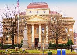 Iredell County Courthouse |
May 10, 1979 (#79003434) |
S. Center St. between W. Prospect St. and Court Pl. 35°47′00″N 80°53′19″W |
Statesville | Built in 1899. |
| 25 | Johnson-Neel House | 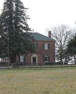 Johnson-Neel House |
June 20, 1975 (#75001275) |
4 miles (6.4 km) west of Mooresville off NC 150 35°35′46″N 80°53′11″W |
Mooresville | Built in 1826-1835. |
| 26 | Key Memorial Chapel | 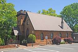 Key Memorial Chapel |
November 24, 1980 (#80002871) |
150 E. Sharpe St. 35°46′55″N 80°53′04″W |
Statesville | Built in 1898. |
| 27 | King-Flowers-Keaton House | November 24, 1980 (#80002872) |
NC 115 and SR 1905 35°53′37″N 80°57′02″W |
Statesville | Built c. 1800 | |
| 28 | Main Building, Mitchell College |  Main Building, Mitchell College |
January 25, 1973 (#73001354) |
Broad St. 35°46′58″N 80°53′39″W |
Statesville | Built in 1854-1856. |
| 29 | McClelland-Davis House | November 24, 1980 (#80002873) |
SR 1551 35°49′51″N 80°55′28″W |
Statesville | Built c. 1830 | |
| 30 | McElwee Houses |  McElwee Houses |
November 24, 1980 (#80002874) |
122, 126, 134 and 140 Water St. 35°47′11″N 80°53′15″W |
Statesville | Built in 1900-1910 |
| 31 | Mitchell College Historic District | Mitchell College Historic District |
November 24, 1980 (#80002875) |
NC 90 and U.S. 70; also roughly bounded by Mulberry, Race, Cherry, Oak, and Alexander Sts. 35°47′04″N 80°54′16″W |
Statesville | Built in 1885-1930. Second set of boundaries represents a boundary increase of September 6, 2002 |
| 32 | Mooresville Historic District | .jpg) Mooresville Historic District |
November 24, 1980 (#80002861) |
NC 115 and NC 152; also includes properties fronting West Center Ave. from North Academy St. to Sherrill St.; Charlotte St.; 300 blk. of West McLelland Ave.; and properties fronting South Academy St. from West McLelland Ave. to Wilson St. 35°35′03″N 80°48′48″W |
Mooresville | Second set of addresses represent a boundary increase approved April 23, 2020. |
| 33 | Mooresville Mill Village Historic District |  Mooresville Mill Village Historic District |
April 24, 2012 (#12000238) |
Bounded by Wilson, Cauldwell, Kennette, Lutz, Messeck, and Catawba Aves., Smith and Bruce Sts., and Shearers Rd. 35°34′26″N 80°49′26″W |
Mooresville | Built in 1902-1930. |
| 34 | Morrison-Campbell House | November 24, 1980 (#80002853) |
Off SR 2125 35°58′00″N 80°44′04″W |
Harmony | Built c. 1860 | |
| 35 | Morrison-Mott House |  Morrison-Mott House |
November 24, 1980 (#80002876) |
332 N. Center St. 35°47′21″N 80°53′25″W |
Statesville | Built in 1904-1905. |
| 36 | Mount Mourne | 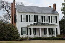 Mount Mourne |
October 29, 1974 (#74001354) |
Off NC 115 35°32′19″N 80°50′58″W |
Mount Mourne | Built in 1836. |
| 37 | Reid Memorial Presbyterian Church | April 23, 2020 (#100005198) |
336 North Broad St. 35°35′11″N 80°48′33″W |
Mooresville | ||
| 38 | Col. Silas Alexander Sharpe House |  Col. Silas Alexander Sharpe House |
November 24, 1980 (#80002877) |
402 S. Center St. 35°46′53″N 80°53′14″W |
Statesville | Built in 1860-1865. |
| 39 | Snow Creek Methodist Church and Burying Ground | November 24, 1980 (#80002854) |
Off SR 1904 35°54′37″N 80°55′12″W |
Harmony | Built in 1884-1885. Church established in 1801. Graveyard from 1780. | |
| 40 | South Broad Street Row |  South Broad Street Row |
November 24, 1980 (#80002862) |
251-311 S. Broad St. 35°34′50″N 80°49′01″W |
Mooresville | Built in 1890-1895. |
| 41 | South Race Street Historic District |  South Race Street Historic District |
May 26, 1995 (#95000635) |
Roughly bounded by S. Race St., Western Ave., W. Armfield St., W. Bell St., W. Sharpe St., and S. Oak St. 35°46′40″N 80°53′37″W |
Statesville | Built in 1898-1909. |
| 42 | Statesville Commercial Historic District | .jpg) Statesville Commercial Historic District |
November 24, 1980 (#80002878) |
Roughly bounded by Front, Meeting, Broad, and Tradd Sts. 35°47′04″N 80°54′18″W |
Statesville | Built in 1875-1925. |
| 43 | Henry Turner House and Caldwell-Turner Mill Site | November 24, 1980 (#80002879) |
SR 2145 35°51′45″N 80°43′37″W |
Statesville | Built c. 1860 | |
| 44 | United States Post Office and Court House-Statesville |  United States Post Office and Court House-Statesville |
April 26, 2018 (#100002363) |
200 W. Broad St. 35°47′03″N 80°53′25″W |
Statesville | |
| 45 | U.S. Post Office and County Courthouse |  U.S. Post Office and County Courthouse |
January 24, 1974 (#74001355) |
227 S. Center St. 35°46′59″N 80°53′15″W |
Statesville | Built in 1891. |
| 46 | Waddle-Click Farm | June 24, 1982 (#82003474) |
SR 2309 35°46′46″N 80°44′31″W |
Statesville | Built in 1820-1835. | |
| 47 | Welch-Nicholson House and Mill Site | December 8, 1980 (#80002858) |
Statesville vicinity 36°02′56″N 80°46′11″W |
Houstonville | Built in 1795. | |
| 48 | Wood Lawn | November 24, 1980 (#80002866) |
SR 1138 35°31′05″N 80°50′05″W |
Mount Mourne | Built in 1836 by Dr. George Washington Stinson. |
See also
| Wikimedia Commons has media related to National Register of Historic Places in Iredell County, North Carolina. |
References
- The latitude and longitude information provided in this table was derived originally from the National Register Information System, which has been found to be fairly accurate for about 99% of listings. Some locations in this table may have been corrected to current GPS standards.
- "National Register of Historic Places: Weekly List Actions". National Park Service, United States Department of the Interior. Retrieved on June 19, 2020.
- Numbers represent an ordering by significant words. Various colorings, defined here, differentiate National Historic Landmarks and historic districts from other NRHP buildings, structures, sites or objects.
- "National Register Information System". National Register of Historic Places. National Park Service. April 24, 2008.
- The eight-digit number below each date is the number assigned to each location in the National Register Information System database, which can be viewed by clicking the number.

| Topics | |
|---|---|
| Lists by state |
|
| Lists by insular areas | |
| Lists by associated state | |
| Other areas | |
| Related | |
| |
Municipalities and communities of Iredell County, North Carolina, United States | ||
|---|---|---|
| City | Iredell County map | |
| Towns | ||
| CDP | ||
| Townships | ||
| Unincorporated communities | ||
| Footnotes | ‡This populated place also has portions in an adjacent county or counties | |
This article is issued from Wikipedia. The text is licensed under Creative Commons - Attribution - Sharealike. Additional terms may apply for the media files.