National Register of Historic Places listings in Moore County, North Carolina
This list includes properties and districts listed on the National Register of Historic Places in Moore County, North Carolina. Click the "Map of all coordinates" link to the right to view a Google map of all properties and districts with latitude and longitude coordinates in the table below.[1]
Current listings
- This National Park Service list is complete through NPS recent listings posted June 19, 2020.[2]
| [3] | Name on the Register[4] | Image | Date listed[5] | Location | City or town | Description |
|---|---|---|---|---|---|---|
| 1 | Aberdeen Historic District | 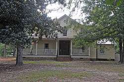 Aberdeen Historic District |
June 28, 1989 (#89000663) |
Roughly bounded by Maple Ave., Bethesda Ave., Campbell St., Main St., Pine St., South St., and Poplar St. 35°07′53″N 79°25′29″W |
Aberdeen | |
| 2 | Alston House | 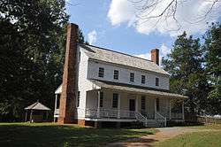 Alston House |
February 26, 1970 (#70000462) |
SE of Glendon on SR 1624 35°28′00″N 79°23′02″W |
Glendon | |
| 3 | Bethesda Presbyterian Church | 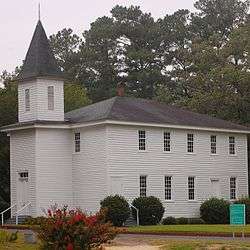 Bethesda Presbyterian Church |
July 22, 1979 (#79003345) |
NC 5 35°07′52″N 79°24′45″W |
Aberdeen | |
| 4 | J.C. Black House | 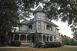 J.C. Black House |
July 8, 1999 (#99000811) |
106 McNeill St. 35°20′44″N 79°24′55″W |
Carthage | |
| 5 | Black-Cole House | September 18, 1978 (#78001967) |
NW of Eastwood 35°16′03″N 79°29′16″W |
Eastwood | ||
| 6 | Daniel Blue House | July 21, 1983 (#83001897) |
SR 1836 35°16′55″N 79°25′32″W |
Carthage | ||
| 7 | John Blue House | July 29, 1982 (#82003488) |
200 Blue St. 35°07′50″N 79°25′22″W |
Aberdeen | ||
| 8 | Malcolm Blue Farm | 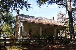 Malcolm Blue Farm |
June 1, 1982 (#82003489) |
Bethesda Rd. and Ernest L. Ives Dr. 35°08′08″N 79°24′38″W |
Aberdeen | |
| 9 | James Boyd House | 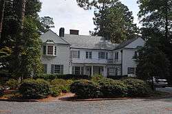 James Boyd House |
May 12, 1977 (#77001005) |
Ridge Rd. and Connecticut Ave. 35°10′14″N 79°23′00″W |
Southern Pines | |
| 10 | Bruce-Dowd-Kennedy House | September 29, 1980 (#80002888) |
Monroe and Rockingham Sts. 35°20′34″N 79°24′48″W |
Carthage | ||
| 11 | James Bryant House | April 15, 1982 (#82003490) |
On SR 1210 35°19′07″N 79°32′41″W |
Harris Crossroads | ||
| 12 | Cameron Historic District | March 17, 1983 (#83001898) |
Carthage St. from US 1 to Seaboard RR Tracks 35°19′36″N 79°15′28″W |
Cameron | ||
| 13 | Carthage Historic District |  Carthage Historic District |
March 19, 1992 (#92000182) |
Roughly, McReynolds St. between Barrett St. and Glendons Rd. and parts of Barrett, Ray, Pinecrest and Brooklyn Sts. 35°21′04″N 79°25′23″W |
Carthage | |
| 14 | Firleigh Farms | May 19, 2014 (#14000229) |
252 Fir Leigh Rd. 35°10′16″N 79°21′17″W |
Southern Pines | ||
| 15 | Gordon Payne Site (31MR15) | September 24, 1986 (#86001954) |
Address Restricted |
High Falls | ||
| 16 | Jugtown Pottery | November 12, 1999 (#99001284) |
330 Jugtown Rd. 35°30′27″N 79°39′06″W |
Seagrove | ||
| 17 | Alexander Kelly House |  Alexander Kelly House |
May 2, 2002 (#02000438) |
NC 1640, 0.3 miles SE of jct. with NC 1666 35°22′34″N 79°26′46″W |
Carthage | |
| 18 | Lakeview Historic District | May 18, 2000 (#00000513) |
Camp Easter Rd., Crystal Lake Dr., Holly Rd., Matthews Rd., and McFayden Ln. 35°14′25″N 79°18′41″W |
Lakeview | ||
| 19 | Leslie-Taylor House | January 17, 2008 (#07001407) |
270 Carthage Rd. 35°15′26″N 79°17′47″W |
Vass | ||
| 20 | Lincoln Park School | February 27, 1997 (#97000167) |
1272 S. Currant St. 35°05′06″N 79°28′25″W |
Pinebluff | ||
| 21 | Lloyd-Howe House | 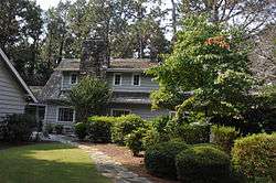 Lloyd-Howe House |
September 8, 1983 (#83001899) |
SW of Pinehurst 35°11′15″N 79°29′38″W |
Pinehurst | |
| 22 | McLeod Family Rural Complex | December 20, 1984 (#84000561) |
.4 miles west of US 1 35°04′33″N 79°30′06″W |
Pinebluff | ||
| 23 | Moore County Courthouse |  Moore County Courthouse |
May 10, 1979 (#79001738) |
Ray, Dowd, Monroe, and Sanders Sts. circle 35°20′44″N 79°25′00″W |
Carthage | |
| 24 | Moore County Hunt Lands and Mile-Away Farms | September 9, 2013 (#13000700) |
1745 N. May St. 35°11′14″N 79°22′00″W |
Southern Pines | ||
| 25 | John Evander Phillips House | October 6, 2000 (#00001184) |
NC 24/27, 0.3 mi outside Cameron 35°19′47″N 79°15′45″W |
Cameron | ||
| 26 | Pinehurst Historic District | _001.jpg) Pinehurst Historic District |
August 14, 1973 (#73001361) |
Roughly bounded by Norfolk & Southern RR tracks, McLean Rd. and NC 5 35°11′41″N 79°28′11″W |
Pinehurst | |
| 27 | Pinehurst Race Track |  Pinehurst Race Track |
November 27, 1992 (#92001628) |
Jct. of Morgantown Rd. and NC 5, SE corner 35°10′54″N 79°27′59″W |
Pinehurst | |
| 28 | Shaw House | Shaw House |
June 17, 1993 (#93000542) |
780 SW. Broad St. 35°10′05″N 79°24′06″W |
Southern Pines | |
| 29 | Southern Pines Historic District |  Southern Pines Historic District |
December 27, 1991 (#91001875) |
Bounded by Saylor St., New Jersey Ave., Illinois Ave. and Massachusetts Ave. Ext. 35°10′10″N 79°23′17″W |
Southern Pines |
See also
| Wikimedia Commons has media related to National Register of Historic Places in Moore County, North Carolina. |
References
- The latitude and longitude information provided in this table was derived originally from the National Register Information System, which has been found to be fairly accurate for about 99% of listings. Some locations in this table may have been corrected to current GPS standards.
- "National Register of Historic Places: Weekly List Actions". National Park Service, United States Department of the Interior. Retrieved on June 19, 2020.
- Numbers represent an ordering by significant words. Various colorings, defined here, differentiate National Historic Landmarks and historic districts from other NRHP buildings, structures, sites or objects.
- "National Register Information System". National Register of Historic Places. National Park Service. April 24, 2008.
- The eight-digit number below each date is the number assigned to each location in the National Register Information System database, which can be viewed by clicking the number.

| Topics | |
|---|---|
| Lists by state |
|
| Lists by insular areas | |
| Lists by associated state | |
| Other areas | |
| Related | |
| |
Municipalities and communities of Moore County, North Carolina, United States | ||
|---|---|---|
| City | | |
| Towns | ||
| Villages | ||
| CDP | ||
| Unincorporated communities | ||
This article is issued from Wikipedia. The text is licensed under Creative Commons - Attribution - Sharealike. Additional terms may apply for the media files.