National Register of Historic Places listings in Stanly County, North Carolina
This list includes properties and districts listed on the National Register of Historic Places in Stanly County, North Carolina. Click the "Map of all coordinates" link to the right to view an online map of all properties and districts with latitude and longitude coordinates in the table below.[1]
Current listings
- This National Park Service list is complete through NPS recent listings posted June 19, 2020.[2]
| [3] | Name on the Register[4] | Image | Date listed[5] | Location | City or town | Description |
|---|---|---|---|---|---|---|
| 1 | Albemarle Graded School-Central Elementary School | December 2, 2014 (#14000991) |
219 E. North St. 35°21′08″N 80°11′45″W |
Albemarle | ||
| 2 | Badin Historic District | October 12, 1983 (#83004000) |
Roughly bounded by NC 740, Pine St., and the country club property line 35°24′13″N 80°06′45″W |
Badin | ||
| 3 | Thomas Marcellus Denning House | 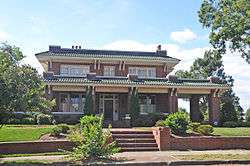 Thomas Marcellus Denning House |
January 24, 2011 (#10001177) |
415 N. Second St. 35°21′22″N 80°11′53″W |
Albemarle | |
| 4 | Downtown Albemarle Historic District |  Downtown Albemarle Historic District |
March 28, 2002 (#02000275) |
Portions of S. 2nd, W. Main and N. and S. 1st Sts. 35°21′00″N 80°11′58″W |
Albemarle | |
| 5 | Five Points Historic District |  Five Points Historic District |
October 16, 2002 (#02001179) |
Junction of E. Main St., Pee Dee Ave., and 4th St. 35°21′01″N 80°11′41″W |
Albemarle | |
| 6 | Hardaway Site (31ST4) | March 1, 1984 (#84002529) |
By Badin Lake, west of the Badin Dam[6] 35°25′08″N 80°06′02″W |
Badin | ||
| 7 | Narrows Dam and Power Plant Complex |  Narrows Dam and Power Plant Complex |
October 12, 1983 (#83004001) |
Yadkin River and SR 1704 35°25′07″N 80°05′33″W |
Badin | |
| 8 | Opera House-Starnes Jewelers Building |  Opera House-Starnes Jewelers Building |
March 9, 1995 (#95000180) |
127-133 W. Main St. 35°21′01″N 80°11′56″W |
Albemarle | |
| 9 | Pee Dee Avenue Historic District |  Pee Dee Avenue Historic District |
January 7, 1998 (#97001612) |
Along Pee Dee Ave., roughly from Arey Ave. to Miller St. 35°21′12″N 80°11′13″W |
Albemarle | |
| 10 | Pfeiffer Junior College Historic District |  Pfeiffer Junior College Historic District |
April 28, 1999 (#99000480) |
U.S. Route 52, 1.0 mile north of its junction with NC 49 35°29′05″N 80°17′04″W |
Misenheimer | |
| 11 | Randle House |  Randle House |
September 8, 1992 (#92001172) |
Southern side of NC 1802 at its junction with NC 1743 35°15′45″N 80°06′15″W |
Norwood | |
| 12 | Richfield Milling Company | September 19, 2016 (#16000647) |
303 S. Main St. 35°27′57″N 80°15′40″W |
Richfield | ||
| 13 | Second Street Historic District | 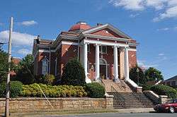 Second Street Historic District |
April 6, 2005 (#05000266) |
Portions of the 100 and 200 blocks of N. Second St. and the 100 block of W. North St. 35°21′08″N 80°11′54″W |
Albemarle | |
| 14 | Isaiah Wilson Snugs House | 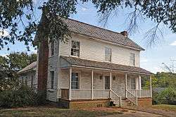 Isaiah Wilson Snugs House |
March 9, 1995 (#95000190) |
112 N. Third St. 35°21′03″N 80°11′46″W |
Albemarle | |
| 15 | West Badin Historic District | October 12, 1983 (#83004002) |
Roughly bounded by Sims, Lincoln, Marion, and Lee Sts. 35°24′35″N 80°07′28″W |
Badin |
See also
| Wikimedia Commons has media related to National Register of Historic Places in Stanly County, North Carolina. |
References
- The latitude and longitude information provided in this table was derived originally from the National Register Information System, which has been found to be fairly accurate for about 99% of listings. Some locations in this table may have been corrected to current GPS standards.
- "National Register of Historic Places: Weekly List Actions". National Park Service, United States Department of the Interior. Retrieved on June 19, 2020.
- Numbers represent an ordering by significant words. Various colorings, defined here, differentiate National Historic Landmarks and historic districts from other NRHP buildings, structures, sites or objects.
- "National Register Information System". National Register of Historic Places. National Park Service. April 24, 2008.
- The eight-digit number below each date is the number assigned to each location in the National Register Information System database, which can be viewed by clicking the number.
- Master Site Record, Research Laboratories of Archaeology, University of North Carolina at Chapel Hill, n.d. Accessed 2014-06-23.

| Topics | |
|---|---|
| Lists by state |
|
| Lists by insular areas | |
| Lists by associated state | |
| Other areas | |
| Related | |
| |
Municipalities and communities of Stanly County, North Carolina, United States | ||
|---|---|---|
| Cities | Stanly County map | |
| Towns | ||
| CDPs | ||
| Unincorporated communities | ||
| Footnotes | ‡This populated place also has portions in an adjacent county or counties | |
This article is issued from Wikipedia. The text is licensed under Creative Commons - Attribution - Sharealike. Additional terms may apply for the media files.