National Register of Historic Places listings in Lincoln County, North Carolina
This list includes properties and districts listed on the National Register of Historic Places in Lincoln County, North Carolina. Click the "Map of all coordinates" link to the right to view an online map of all properties and districts with latitude and longitude coordinates in the table below.[1]
Current listings
- This National Park Service list is complete through NPS recent listings posted June 19, 2020.[2]
| [3] | Name on the Register[4] | Image | Date listed[5] | Location | City or town | Description |
|---|---|---|---|---|---|---|
| 1 | Caldwell-Cobb-Love House | 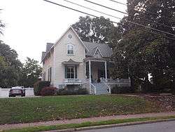 Caldwell-Cobb-Love House |
February 6, 1986 (#86000159) |
218 E. Congress St. 35°28′08″N 81°15′13″W |
Lincolnton | |
| 2 | Emanuel United Church of Christ | 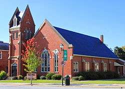 Emanuel United Church of Christ |
December 14, 1994 (#94001453) |
329 E. Main St. 35°28′22″N 81°15′11″W |
Lincolnton | Built in 1913, designed by Henry E. Bonitz |
| 3 | Emmanuel Lutheran Church | 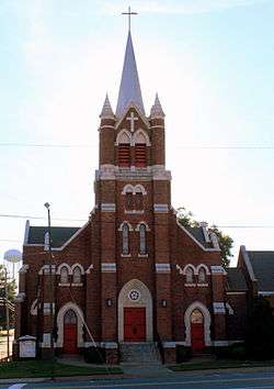 Emmanuel Lutheran Church |
December 14, 1994 (#94001454) |
216 S. Aspen St. 35°28′11″N 81°15′26″W |
Lincolnton | |
| 4 | Eureka Manufacturing Company Cotton Mill | %2C_Lincolnton%2C_NC.jpg) Eureka Manufacturing Company Cotton Mill |
December 18, 2013 (#13000934) |
414 E. Water St. 35°28′20″N 81°15′07″W |
Lincolnton | |
| 5 | First Baptist Church |  First Baptist Church |
December 21, 1994 (#94001456) |
403 E. Main St. 35°28′24″N 81°15′09″W |
Lincolnton | |
| 6 | First Presbyterian Church | %2C_114_W._Main_Street%2C_Lincolnton%2C_NC.jpg) First Presbyterian Church |
December 14, 1994 (#94001455) |
114 W. Main St. 35°28′16″N 81°15′31″W |
Lincolnton | |
| 7 | First United Methodist Church |  First United Methodist Church |
December 14, 1994 (#94001457) |
201 E. Main St. 35°28′19″N 81°15′20″W |
Lincolnton | |
| 8 | William A. Graham Jr. Farm | May 6, 1977 (#77001004) |
S of Denver on SR 1360 35°28′43″N 81°04′05″W |
Kidville | ||
| 9 | Ingleside | .jpg) Ingleside |
April 13, 1972 (#72000967) |
S of jct. of NC 73 and SR 1383 35°27′49″N 81°02′39″W |
Iron Station | |
| 10 | Laboratory Historic District |  Laboratory Historic District |
December 10, 2003 (#03001273) |
Jct. of Laboratory Rd. and S. Fork Rd. 35°26′21″N 81°15′24″W |
Laboratory | |
| 11 | Lincoln County Courthouse | .jpg) Lincoln County Courthouse |
May 10, 1979 (#79001731) |
Courthouse Sq. 35°28′41″N 81°15′26″W |
Lincolnton | |
| 12 | Lincolnton Commercial Historic District | %2C_Lincolnton%2C_NC.jpg) Lincolnton Commercial Historic District |
December 16, 2005 (#05001419) |
Roughly bounded by Pine St., Poplar St., Church St. and W. Court Square 35°28′20″N 81°15′22″W |
Lincolnton | |
| 13 | Lincolnton Recreation Department Youth Center |  Lincolnton Recreation Department Youth Center |
December 30, 2009 (#09001178) |
119 E. Pine St. 35°28′22″N 81°15′27″W |
Lincolnton | |
| 14 | Loretz House | March 16, 1972 (#72000969) |
NW of Lincolnton off SR 1204 35°30′48″N 81°15′53″W |
Lincolnton | ||
| 15 | Madison-Derr Iron Furnace | January 10, 2019 (#100003299) |
Address Restricted |
Pumpkin Center vicinity | ||
| 16 | Magnolia Grove | March 16, 1972 (#72000968) |
Jct. of SR 1309 and 1313 35°25′03″N 81°10′26″W |
Iron Station | Boundaries increased on June 27, 1997 | |
| 17 | Methodist Church Cemetery | December 14, 1994 (#94001458) |
Jct. of S. Aspen and W. Congress Sts., W corner 35°28′04″N 81°15′23″W |
Lincolnton | ||
| 18 | Mount Welcome | September 13, 1991 (#91001413) |
Jct. of NC 1511 and NC 1412 35°25′45″N 81°03′13″W |
Lowesville | ||
| 19 | Old White Church Cemetery | %2C_Lincolnton%2C_NC.jpg) Old White Church Cemetery |
December 14, 1994 (#94001459) |
Jct. of S. Aspen and Church Sts., E corner 35°28′11″N 81°15′21″W |
Lincolnton | |
| 20 | Pleasant Retreat Academy | 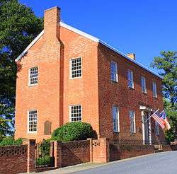 Pleasant Retreat Academy |
May 29, 1975 (#75001277) |
129 E. Pine St. 35°28′20″N 81°15′22″W |
Lincolnton | |
| 21 | Reinhardt-Craig House, Kiln and Pottery Shop | 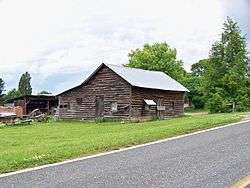 Reinhardt-Craig House, Kiln and Pottery Shop |
January 9, 2008 (#07001376) |
3171 Cat Square Rd. 35°33′47″N 81°25′46″W |
Vale | |
| 22 | Rock Spring Camp Ground |  Rock Spring Camp Ground |
September 22, 1972 (#72000970) |
6831 Campground Rd. 35°32′25″N 81°01′40″W |
Denver | |
| 23 | Salem Union Church and Cemetery | October 4, 1995 (#95001118) |
Jct. of NC 1005 (Startown Rd.) and NC 1274 (Maiden-Salem Rd.), SE corner 35°32′51″N 81°15′54″W |
Maiden | ||
| 24 | Andrew Seagle Farm | February 24, 1975 (#75001278) |
N of Reepsville off SR 1205 35°31′10″N 81°20′46″W |
Reepsville | ||
| 25 | Shadow Lawn | 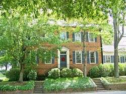 Shadow Lawn |
March 24, 1972 (#72000971) |
301 W. Main St. 35°28′13″N 81°15′36″W |
Lincolnton | |
| 26 | South Aspen Street Historic District | 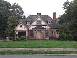 South Aspen Street Historic District |
January 15, 2003 (#02001713) |
500-1000 blocks S. Aspen St., 114-130 E. Rhodes St., and 624-636 W. Park Dr. 35°27′53″N 81°15′16″W |
Lincolnton | |
| 27 | St. Luke's Church and Cemetery | 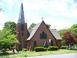 St. Luke's Church and Cemetery |
January 14, 1992 (#91001914) |
303-321 N. Cedar St., 322 E. McBee St. 35°28′27″N 81°15′13″W |
Lincolnton | |
| 28 | Tucker's Grove Camp Meeting Ground | October 18, 1972 (#72000972) |
N of Iron Station off SR 1360 35°28′03″N 81°05′00″W |
Iron Station | ||
| 29 | Vesuvius Furnace | August 13, 1974 (#74001359) |
On SR 1382, N of NC 73 35°29′31″N 81°05′00″W |
Catawba Springs | ||
| 30 | West Main Street Historic District | January 15, 2003 (#02001716) |
200-300 W. Main St. and 114 N. High St. 35°28′13″N 81°15′37″W |
Lincolnton | ||
| 31 | Woodside | March 7, 1973 (#73001357) |
W of jct. of U.S. 182 and 27 35°27′15″N 81°16′42″W |
Lincolnton |
See also
| Wikimedia Commons has media related to National Register of Historic Places in Lincoln County, North Carolina. |
References
- The latitude and longitude information provided in this table was derived originally from the National Register Information System, which has been found to be fairly accurate for about 99% of listings. Some locations in this table may have been corrected to current GPS standards.
- "National Register of Historic Places: Weekly List Actions". National Park Service, United States Department of the Interior. Retrieved on June 19, 2020.
- Numbers represent an ordering by significant words. Various colorings, defined here, differentiate National Historic Landmarks and historic districts from other NRHP buildings, structures, sites or objects.
- "National Register Information System". National Register of Historic Places. National Park Service. April 24, 2008.
- The eight-digit number below each date is the number assigned to each location in the National Register Information System database, which can be viewed by clicking the number.

| Topics | |
|---|---|
| Lists by state |
|
| Lists by insular areas | |
| Lists by associated state | |
| Other areas | |
| Related | |
| |
Municipalities and communities of Lincoln County, North Carolina, United States | ||
|---|---|---|
| City | | |
| Towns |
| |
| CDPs | ||
| Unincorporated communities | ||
| Footnotes | ‡This populated place also has portions in an adjacent county or counties | |
This article is issued from Wikipedia. The text is licensed under Creative Commons - Attribution - Sharealike. Additional terms may apply for the media files.