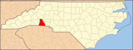
National Register of Historic Places listings in Cleveland County, North Carolina
This list includes properties and districts listed on the National Register of Historic Places in Cleveland County, North Carolina. Click the "Map of all coordinates" link to the right to view an online map of all properties and districts with latitude and longitude coordinates in the table below.[1]
Current listings
- This National Park Service list is complete through NPS recent listings posted June 19, 2020.[2]
| [3] | Name on the Register[4] | Image | Date listed[5] | Location | City or town | Description |
|---|---|---|---|---|---|---|
| 1 | Banker's House |  Banker's House |
May 6, 1975 (#75001251) |
319 N. Lafayette St. 35°17′44″N 81°32′22″W |
Shelby | |
| 2 | Joshua Beam House |  Joshua Beam House |
June 4, 1980 (#80002813) |
Northeast of Shelby 35°20′47″N 81°29′10″W |
Shelby | |
| 3 | Central School Historic District |  Central School Historic District |
May 18, 2001 (#01000513) |
Roughly N. Battleground Ave., N. Piedmont Ave., E. King St., E. Ridge Ave., and N. Gaston St. 35°14′34″N 81°20′34″W |
Kings Mountain | |
| 4 | Central Shelby Historic District |  Central Shelby Historic District |
June 23, 1983 (#83001841) |
Roughly Washington St. from Gidney to Sumter, Graham and Warren Sts. to Morgan, and Marion St. from Washington St. to Thompson; also roughly bounded by E. Elm, S. Lafayette, Blanton, N. Thompson, W. Sumter, N. Lafayette, Kendal, and S. Dekalb Sts. 35°17′17″N 81°32′33″W |
Shelby | Second set of boundaries represents a boundary increase of September 14, 2002 |
| 5 | Cleveland County Courthouse | 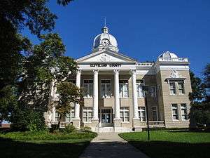 Cleveland County Courthouse |
May 10, 1979 (#79001693) |
Marion, Washington, Warren, and Lafayette Sts. 35°17′29″N 81°32′22″W |
Shelby | Also called Old Cleveland County Courthouse. |
| 6 | Cleveland County Training School | 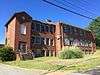 Cleveland County Training School |
May 2, 2016 (#16000220) |
341 Hudson St. 35°17′56″N 81°32′00″W |
Shelby | |
| 7 | Davidson Elementary School | 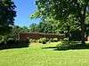 Davidson Elementary School |
May 18, 2016 (#16000287) |
500 W. Piedmont Ave. 35°14′41″N 81°21′07″W |
Kings Mountain | |
| 8 | Double Shoals Cotton Mill |  Double Shoals Cotton Mill |
March 24, 2009 (#08000775) |
199 Old Mill Rd. 35°22′51″N 81°32′43″W |
Double Shoals | |
| 9 | East Marion-Belvedere Park Historic District | 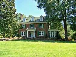 East Marion-Belvedere Park Historic District |
December 31, 2002 (#02001667) |
Roughly bounded by Cline, Chestnut, E. Marion Sts., Edgemont Ave, Belvedere Aves., and Elizabeth Rd. 35°17′36″N 81°31′36″W |
Shelby | |
| 10 | E. B. Hamrick Hall |  E. B. Hamrick Hall |
July 12, 1982 (#82003444) |
Gardner-Webb College campus 35°14′58″N 81°40′05″W |
Boiling Springs | |
| 11 | James Heyward Hull House | 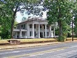 James Heyward Hull House |
May 1, 2003 (#03000338) |
710 N. Lafayette St. 35°18′01″N 81°32′22″W |
Shelby | |
| 12 | Irvin-Hamrick Log House |  Irvin-Hamrick Log House |
May 28, 1980 (#80002811) |
Northwest of Boiling Springs on SR 1153 35°16′35″N 81°37′33″W |
Boiling Springs | |
| 13 | King Street Overhead Bridge |  King Street Overhead Bridge |
April 6, 2005 (#05000268) |
King St. between Battleground and Railroad Aves. 35°14′27″N 81°20′41″W |
Kings Mountain | |
| 14 | John Lattimore House | August 26, 1982 (#82003445) |
Northwest of Polkville on SR 1372 35°26′35″N 81°39′57″W |
Polkville | ||
| 15 | Margrace Mill Village Historic District |  Margrace Mill Village Historic District |
May 6, 2009 (#09000288) |
101-117, 102-120 Cloninger St., 101-113, 102-116, 200 Fulton Dr., 145 Ark St., 101-107, 102-114 Water Oak St. 35°13′29″N 81°21′44″W |
Kings Mountain | |
| 16 | Masonic Temple Building | 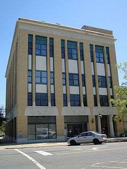 Masonic Temple Building |
July 15, 1982 (#82003446) |
203 S. Washington St. 35°16′54″N 81°32′18″W |
Shelby | |
| 17 | Jacob S. Mauney Memorial Library and Teacher's Home |  Jacob S. Mauney Memorial Library and Teacher's Home |
December 16, 2014 (#14001049) |
100 S. Piedmont Ave. 35°14′27″N 81°20′34″W |
Kings Mountain | |
| 18 | Dr. Victor McBrayer House |  Dr. Victor McBrayer House |
May 31, 1979 (#79001694) |
507 N. Morgan St. 35°17′39″N 81°32′30″W |
Shelby | |
| 19 | Shelby Cotton Mill | 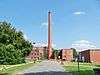 Shelby Cotton Mill |
December 15, 2015 (#15000898) |
500 S. Morgan St. 35°17′09″N 81°32′33″W |
Shelby | |
| 20 | Shiloh Presbyterian Church Cemetery | 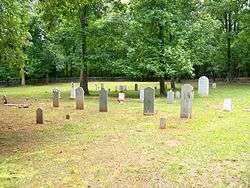 Shiloh Presbyterian Church Cemetery |
December 22, 2011 (#11000954) |
Elm St., 0.9 miles (1.4 km) south of U.S. Route 29 35°10′09″N 81°25′57″W |
Grover | |
| 21 | Southern Railway Company Overhead Bridge | 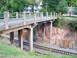 Southern Railway Company Overhead Bridge |
April 19, 2007 (#07000351) |
Spanning the double tracks on the Norfolk Southern Railroad between Battleground and Railroad Aves., 1/2 block north of King St. 35°14′29″N 81°20′41″W |
Kings Mountain | |
| 22 | George Sperling House and Outbuildings |  George Sperling House and Outbuildings |
December 31, 2001 (#01001425) |
1219 Fallston Rd. 35°18′53″N 81°31′22″W |
Shelby | |
| 23 | Stamey Company Store |  Stamey Company Store |
January 10, 2019 (#100003294) |
4726 Fallston Rd. 35°25′41″N 81°30′05″W |
Shelby | |
| 24 | Joseph Suttle House |  Joseph Suttle House |
July 17, 1980 (#80002814) |
Southwest of Shelby 35°15′55″N 81°35′09″W |
Shelby | |
| 25 | United States Post Office | 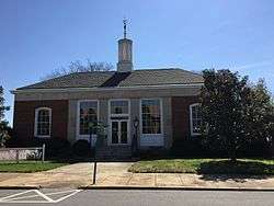 United States Post Office |
April 29, 2015 (#15000202) |
100 E. Mountain St. 35°14′21″N 81°20′32″W |
Kings Mountain | Now the Kings Mountain Historical Museum |
| 26 | Webbley | _-_Shelby%2C_NC.jpg) Webbley |
September 29, 1980 (#80002812) |
403 S. Washington St. 35°17′14″N 81°32′20″W |
Shelby | |
| 27 | West End Historic District |  West End Historic District |
September 3, 2010 (#10000630) |
Bounded by W. Mountain St., W. Gold St., S. Cansler St., S. Tracy St., S. Watterson St., and S. Goforth St. 35°14′19″N 81°21′00″W |
Kings Mountain | |
| 28 | West Warren Street Historic District |  West Warren Street Historic District |
May 12, 2009 (#09000331) |
Roughly bounded by W. Warren, McBrayer, Blanton, and Whisnant Sts. 35°17′28″N 81°32′40″W |
Shelby |
See also
| Wikimedia Commons has media related to National Register of Historic Places in Cleveland County, North Carolina. |
References
- The latitude and longitude information provided in this table was derived originally from the National Register Information System, which has been found to be fairly accurate for about 99% of listings. Some locations in this table may have been corrected to current GPS standards.
- "National Register of Historic Places: Weekly List Actions". National Park Service, United States Department of the Interior. Retrieved on June 19, 2020.
- Numbers represent an ordering by significant words. Various colorings, defined here, differentiate National Historic Landmarks and historic districts from other NRHP buildings, structures, sites or objects.
- "National Register Information System". National Register of Historic Places. National Park Service. April 24, 2008.
- The eight-digit number below each date is the number assigned to each location in the National Register Information System database, which can be viewed by clicking the number.

| Topics | |
|---|---|
| Lists by state |
|
| Lists by insular areas | |
| Lists by associated state | |
| Other areas | |
| Related | |
| |
Municipalities and communities of Cleveland County, North Carolina, United States | ||
|---|---|---|
| Cities | | |
| Towns | ||
| CDP | ||
| Unincorporated communities | ||
| Footnotes | ‡This populated place also has portions in an adjacent county or counties | |
This article is issued from Wikipedia. The text is licensed under Creative Commons - Attribution - Sharealike. Additional terms may apply for the media files.