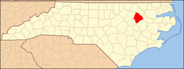
National Register of Historic Places listings in Edgecombe County, North Carolina
This list includes properties and districts listed on the National Register of Historic Places in Edgecombe County, North Carolina, United States. Click the "Map of all coordinates" link to the right to view a Google map of all properties and districts with latitude and longitude coordinates in the table below.[1]
- This National Park Service list is complete through NPS recent listings posted June 19, 2020.[2]
| [3] | Name on the Register[4] | Image | Date listed[5] | Location | City or town | Description |
|---|---|---|---|---|---|---|
| 1 | The Barracks | February 18, 1971 (#71000578) |
1100 Albemarle Ave. 35°54′08″N 77°32′30″W |
Tarboro | ||
| 2 | Batts House and Outbuildings | April 5, 2006 (#06000226) |
E side of US 258 N, 2.05 miles S of NC 1513 5098 US 258 N 35°56′44″N 77°29′55″W |
Tarboro | ||
| 3 | Bracebridge Hall | February 18, 1971 (#71000579) |
Macclesfield vicinity; also 7714 Colonial Rd. and both sides of Colonial Rd. at its junction with Carr Farm Rd. 35°45′40″N 77°32′36″W |
Macclesfield | Second set of boundaries represents a boundary increase of December 16, 2005 | |
| 4 | C.S.S. Col. Hill (side-wheel steamer) | August 24, 2018 (#100002803) |
Address restricted[6] |
Tarboro | ||
| 5 | Calvary Episcopal Church and Churchyard | February 18, 1971 (#71000580) |
411 E. Church St. 35°53′51″N 77°31′56″W |
Tarboro | ||
| 6 | Cedar Lane | April 15, 1982 (#82003451) |
N of Tarboro off NC 44 35°59′05″N 77°30′32″W |
Leggett | ||
| 7 | Coats House | April 3, 1973 (#73001339) |
1503 St. Andrews St. 35°54′25″N 77°32′19″W |
Tarboro | ||
| 8 | Coolmore Plantation | .jpg) Coolmore Plantation |
February 18, 1971 (#71000581) |
Rte. 3 (W of Tarboro on U.S. 64) 35°55′26″N 77°35′40″W |
Tarboro | |
| 9 | Cotton Press | %2C_Tarboro_(Edgecombe_County%2C_North_Carolina).jpg) Cotton Press |
February 18, 1971 (#71000582) |
Town Common 35°53′53″N 77°32′39″W |
Tarboro | |
| 10 | Eastern Star Baptist Church | April 2, 1980 (#80002827) |
Church and Wagner Sts. 35°53′36″N 77°31′50″W |
Tarboro | ||
| 11 | Edgecombe Agricultural Works | April 2, 1980 (#80002828) |
Roughly bounded by Main, Howard, Albemarle, and Walnut Sts. 35°54′18″N 77°32′27″W |
Tarboro | ||
| 12 | Edgemont Historic District | November 12, 1999 (#99001365) |
500-800 blocks of Tarboro St., the 600-800 blocks of Hill St., and the southern side of the 600-800 blocks of Sycamore St.; also roughly bounded by Cokey Rd., George St., Eastern Ave., Edgewood St., and School St. 35°56′10″N 77°47′19″W |
Rocky Mount | Second set of boundaries represents a boundary increase of September 14, 2002 | |
| 13 | The Grove | February 18, 1971 (#71000583) |
130 Bridgers St. 35°54′10″N 77°32′14″W |
Tarboro | ||
| 14 | Howell Homeplace | December 20, 1984 (#84000532) |
SR 1517 35°54′40″N 77°28′05″W |
Tarboro | ||
| 15 | Lincoln Park Historic District | January 20, 2012 (#11001042) |
800 block of Ellison Dr., 800-900 & 1000-1002 Leggett Rd. & 800 Carver Pl. 35°57′15″N 77°46′45″W |
Rocky Mount | ||
| 16 | Lone Pine | November 6, 1987 (#87001901) |
SR 1207, S of US 64 35°54′48″N 77°36′09″W |
Tarboro | ||
| 17 | Mount Prospect | November 20, 1974 (#74001347) |
Jct. of SR 1409 and SR 1428 36°00′27″N 77°38′29″W |
Leggett | Also known as Exum-Lewis House; burned[7] | |
| 18 | Dr. A. B. Nobles House and McKendree Church | June 19, 1980 (#80002825) |
NW of Mercer on SR 1224 35°52′12″N 77°39′26″W |
Mercer | ||
| 19 | Oakland Plantation | April 2, 1980 (#80002829) |
Edmondson St. 35°53′47″N 77°32′27″W |
Tarboro | ||
| 20 | Old Town Plantation | December 1, 1983 (#72000961) |
Off NC 97 35°58′54″N 77°43′52″W |
Battleboro | ||
| 21 | Piney Prospect | February 18, 1971 (#71000584) |
5.7 miles S of Tarboro off SR 1601 35°48′49″N 77°34′01″W |
Tarboro | ||
| 22 | Porter Houses and Armstrong Kitchen | September 14, 2002 (#02000988) |
821 Wells Rd. 36°03′55″N 77°40′01″W |
Whitakers | ||
| 23 | Princeville School | January 9, 2001 (#00001615) |
US 258, 0.3 miles E of NC 64 35°53′24″N 77°31′37″W |
Princeville | ||
| 24 | Quigless Clinic | October 27, 2000 (#00001232) |
99 Main St. 35°53′40″N 77°31′58″W |
Tarboro | ||
| 25 | Railroad Depot Complex | April 2, 1980 (#80002830) |
Off N. Main St. 35°54′23″N 77°32′32″W |
Tarboro | ||
| 26 | Redmond-Shackelford House | December 12, 1976 (#76001320) |
300 Main St. 35°53′46″N 77°32′08″W |
Tarboro | ||
| 27 | Rocky Mount Central City Historic District | 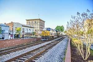 Rocky Mount Central City Historic District |
June 19, 1980 (#80002826) |
Portions of 26 blocks on Main, Washington, Church, Battle, Hammond, Hill, Howard, Ivy, Gay, Goldleaf, and Thomas Sts. 35°56′32″N 77°47′42″W |
Rocky Mount | Present boundaries reflect a boundary increase and decrease of August 27, 2009; original boundaries were "roughly bounded by Robinson and Atlantic Aves. and Holly and Franklin Sts." Extends into Nash County |
| 28 | William and Susan Savage House | August 25, 2014 (#14000518) |
704 NC 97 E 35°59′42″N 77°34′11″W |
Leggett | ||
| 29 | St. John's Episcopal Church | February 18, 1971 (#71000577) |
E. Main St. 36°02′47″N 77°44′53″W |
Battleboro | ||
| 30 | St. Paul Baptist Church | April 2, 1980 (#80002831) |
Edmondson St. 35°58′41″N 77°31′54″W |
Tarboro | ||
| 31 | Tarboro Historic District | April 2, 1980 (#80002832) |
Roughly bounded by Albemarle Ave., Walnut, Panola, and Water Sts., and River Rd. 35°53′44″N 77°32′15″W |
Tarboro | ||
| 32 | Tarboro Town Common | September 30, 1970 (#70000453) |
Bounded by Wilson St., Albemarle Ave., Park Ave. and St. Patrick St. 35°53′53″N 77°32′09″W |
Tarboro | ||
| 33 | Upper Town Creek Rural Historic District | August 29, 1986 (#86001656) |
Roughly bounded by NC 1003, NC 1411, NC 1414, and Town Creek 35°47′57″N 77°45′25″W |
Wilson | ||
| 34 | Vinedale | July 15, 1982 (#82003450) |
SW of NC 42/43 and SR 1122 35°46′50″N 77°36′21″W |
Pinetops | ||
| 35 | Walston-Bulluck House | February 18, 1971 (#71000585) |
1018 St. Andrews St. 35°54′10″N 77°32′14″W |
Tarboro | ||
| 36 | Wilkinson-Dozier House | October 23, 1974 (#74001348) |
SE of Tarboro off SR 1524 35°51′52″N 77°26′13″W |
Conetoe | ||
| 37 | Worsley-Burnette House | May 24, 1990 (#90000791) |
SR 1526 N of jct. with SR 1540 35°51′44″N 77°26′13″W |
Conetoe |
See also
| Wikimedia Commons has media related to National Register of Historic Places in Edgecombe County, North Carolina. |
References
- The latitude and longitude information provided in this table was derived originally from the National Register Information System, which has been found to be fairly accurate for about 99% of listings. Some locations in this table may have been corrected to current GPS standards.
- "National Register of Historic Places: Weekly List Actions". National Park Service, United States Department of the Interior. Retrieved on June 19, 2020.
- Numbers represent an ordering by significant words. Various colorings, defined here, differentiate National Historic Landmarks and historic districts from other NRHP buildings, structures, sites or objects.
- "National Register Information System". National Register of Historic Places. National Park Service. April 24, 2008.
- The eight-digit number below each date is the number assigned to each location in the National Register Information System database, which can be viewed by clicking the number.
- Federal and state laws and practices restrict general public access to information regarding the specific location of this resource. In some cases, this is to protect archeological sites from vandalism, while in other cases it is restricted at the request of the owner. See: Knoerl, John; Miller, Diane; Shrimpton, Rebecca H. (1990), Guidelines for Restricting Information about Historic and Prehistoric Resources, National Register Bulletin, National Park Service, U.S. Department of the Interior, OCLC 20706997.
- "North Carolina Listings in the National Register of Historic Places by County". North Carolina State Historic Preservation Office. 22 October 2008. Archived from the original on 30 November 2012. Retrieved 14 July 2009.

| Topics | |
|---|---|
| Lists by state |
|
| Lists by insular areas | |
| Lists by associated state | |
| Other areas | |
| Related | |
| |
Municipalities and communities of Edgecombe County, North Carolina, United States | ||
|---|---|---|
| City | Edgecombe County map | |
| Towns | ||
| Unincorporated communities | ||
| Footnotes | ‡This populated place also has portions in an adjacent county or counties | |
This article is issued from Wikipedia. The text is licensed under Creative Commons - Attribution - Sharealike. Additional terms may apply for the media files.