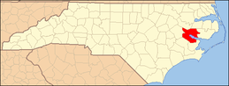
National Register of Historic Places listings in Beaufort County, North Carolina
This list includes properties and districts listed on the National Register of Historic Places in Beaufort County, North Carolina. Click the "Map of all coordinates" link to the right to view an online map of all properties and districts with latitude and longitude coordinates in the table below.[1]
Current listings
- This National Park Service list is complete through NPS recent listings posted June 19, 2020.[2]
| [3] | Name on the Register[4] | Image | Date listed[5] | Location | City or town | Description |
|---|---|---|---|---|---|---|
| 1 | Bank of Washington, West End Branch | 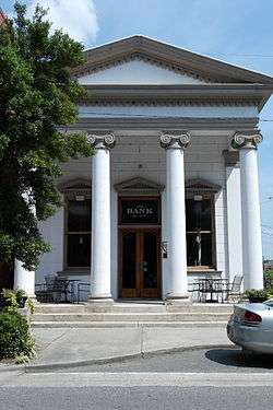 Bank of Washington, West End Branch |
February 18, 1971 (#71000566) |
216 W. Main St. 35°32′36″N 77°03′24″W |
Washington | |
| 2 | Bath Historic District | 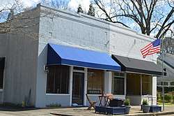 Bath Historic District |
February 26, 1970 (#70000437) |
Bounded by Bath Creek, NC 92, and King St. 35°28′33″N 76°48′50″W |
Bath | |
| 3 | Bath School |  Bath School |
January 30, 2008 (#07001495) |
King and Carteret Sts. 35°28′35″N 76°48′42″W |
Bath | |
| 4 | Beaufort County Courthouse | %2C_Washington.jpg) Beaufort County Courthouse |
March 31, 1971 (#71000567) |
Corner of W. 2nd and Market Sts. 35°32′35″N 77°03′16″W |
Washington | |
| 5 | Belfont Plantation House | December 12, 1976 (#76001305) |
North of Latham on SR 1411 35°37′06″N 77°08′14″W |
Latham | ||
| 6 | Belhaven City Hall | 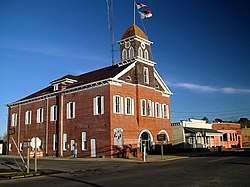 Belhaven City Hall |
January 27, 1981 (#81000420) |
Main St. 35°32′21″N 76°37′18″W |
Belhaven | |
| 7 | Belhaven Commercial Historic District |  Belhaven Commercial Historic District |
April 24, 2015 (#15000180) |
260-292 E. Main and 246-288 and 251-279 Pamlico Sts. 35°32′16″N 76°37′16″W |
Belhaven | |
| 8 | Bonner House |  Bonner House |
February 26, 1970 (#70000438) |
Front St. 35°28′20″N 76°48′49″W |
Bath | |
| 9 | Bowers-Tripp House | 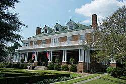 Bowers-Tripp House |
April 1, 1999 (#99000424) |
1040 N. Market St. 35°33′05″N 77°02′56″W |
Washington | |
| 10 | North Market Street Historic District | 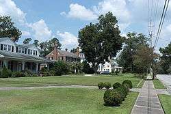 North Market Street Historic District |
October 25, 2011 (#11000767) |
Roughly bounded by 15th, Nicholson, and 6th Sts., and Summit Ave. 35°33′06″N 77°02′56″W |
Washington | |
| 11 | Palmer-Marsh House | .jpg) Palmer-Marsh House |
February 26, 1970 (#70000439) |
Main St., south of NC 92 35°28′36″N 76°48′51″W |
Bath | |
| 12 | Pantego Academy | October 25, 1984 (#84000114) |
Academy St. 35°35′26″N 76°39′47″W |
Pantego | ||
| 13 | Rosedale | April 29, 1982 (#82003424) |
Northwest of Washington off SR 1407 35°35′48″N 77°05′26″W |
Washington | ||
| 14 | St. Thomas Episcopal Church |  St. Thomas Episcopal Church |
November 20, 1970 (#70000440) |
Craven St. 35°28′26″N 76°48′50″W |
Bath | |
| 15 | Trinity Cemetery | 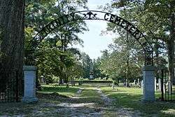 Trinity Cemetery |
August 19, 2011 (#11000545) |
North Carolina Highway 33, 0.07 miles west of its junction with NC 1157 35°30′57″N 77°07′09″W |
Chocowinity | |
| 16 | U.S. ARMY GUNBOAT PICKET (screw steamer) | August 24, 2018 (#100002796) |
Address Restricted |
Washington | ||
| 17 | Ware Creek School |  Ware Creek School |
December 6, 1996 (#96001443) |
Eastern side of NC 1103, 0.3 miles southeast of its junction with NC 1112 35°25′12″N 76°56′19″W |
Blounts Creek | |
| 18 | Washington Historic District | 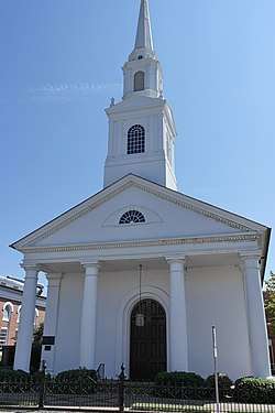 Washington Historic District |
February 9, 1979 (#79001661) |
Roughly bounded by Jacks Creek, the Pamlico River, and Hackney, 3rd, Market, 5th, Harvey, and 2nd Sts. 35°32′37″N 77°03′17″W |
Washington | |
| 19 | Zion Episcopal Church | 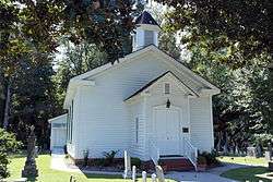 Zion Episcopal Church |
August 16, 2000 (#00000988) |
U.S. Route 264, 0.2 miles east of its junction with NC 1601 35°31′23″N 76°56′05″W |
Washington |
See also
| Wikimedia Commons has media related to National Register of Historic Places in Beaufort County, North Carolina. |
References
- The latitude and longitude information provided in this table was derived originally from the National Register Information System, which has been found to be fairly accurate for about 99% of listings. Some locations in this table may have been corrected to current GPS standards.
- "National Register of Historic Places: Weekly List Actions". National Park Service, United States Department of the Interior. Retrieved on June 19, 2020.
- Numbers represent an ordering by significant words. Various colorings, defined here, differentiate National Historic Landmarks and historic districts from other NRHP buildings, structures, sites or objects.
- "National Register Information System". National Register of Historic Places. National Park Service. April 24, 2008.
- The eight-digit number below each date is the number assigned to each location in the National Register Information System database, which can be viewed by clicking the number.

| Topics | |
|---|---|
| Lists by state |
|
| Lists by insular areas | |
| Lists by associated state | |
| Other areas | |
| Related | |
| |
Municipalities and communities of Beaufort County, North Carolina, United States | ||
|---|---|---|
| City | | |
| Towns | ||
| CDPs | ||
| Unincorporated communities |
| |
This article is issued from Wikipedia. The text is licensed under Creative Commons - Attribution - Sharealike. Additional terms may apply for the media files.