Brunswick, North Carolina
Brunswick is a town in Columbus County, North Carolina, United States. The population was 1,119 at the 2010 census.
Brunswick, North Carolina | |
|---|---|
 Brunswick Location within the state of North Carolina | |
| Coordinates: 34°17′34″N 78°42′25″W | |
| Country | United States |
| State | North Carolina |
| County | Columbus |
| Area | |
| • Total | 0.4 sq mi (1.1 km2) |
| • Land | 0.4 sq mi (1.1 km2) |
| • Water | 0.0 sq mi (0.0 km2) |
| Elevation | 79 ft (24 m) |
| Population (2010) | |
| • Total | 1,119 |
| • Estimate (2018)[1] | 971 |
| • Density | 2,800/sq mi (1,000/km2) |
| Time zone | UTC-5 (Eastern (EST)) |
| • Summer (DST) | UTC-4 (EDT) |
| ZIP code | 28424 |
| Area code(s) | 910 |
| FIPS code | 37-08420[2] |
| GNIS feature ID | 0982045[3] |
Geography
Brunswick is located at 34°17′34″N 78°42′25″W (34.292821, -78.706930).[4]
According to the United States Census Bureau, the town has a total area of 0.4 square miles (1.0 km2), all of it land.
Demographics
| Historical population | |||
|---|---|---|---|
| Census | Pop. | %± | |
| 1930 | 416 | — | |
| 1940 | 227 | −45.4% | |
| 1950 | 190 | −16.3% | |
| 1960 | 169 | −11.1% | |
| 1970 | 206 | 21.9% | |
| 1980 | 223 | 8.3% | |
| 1990 | 302 | 35.4% | |
| 2000 | 360 | 19.2% | |
| 2010 | 1,119 | 210.8% | |
| Est. 2018 | 971 | [1] | −13.2% |
| U.S. Decennial Census[5] | |||
At the 2000 census there were 360 people, 144 households, and 101 families in the town. The population density was 866.9 people per square mile (330.9/km²). There were 165 housing units at an average density of 397.3 per square mile (151.7/km²). The racial makeup of the town was 41.94% White, 55.00% African American, 2.78% Native American, and 0.28% from two or more races. Hispanic or Latino of any race were 0.83%.[2]
Of the 144 households 27.1% had children under the age of 18 living with them, 40.3% were married couples living together, 26.4% had a female householder with no husband present, and 29.2% were non-families. 25.7% of households were one person and 9.7% were one person aged 65 or older. The average household size was 2.50 and the average family size was 3.02.
The age distribution was 23.6% under the age of 18, 10.8% from 18 to 24, 21.9% from 25 to 44, 23.9% from 45 to 64, and 19.7% 65 or older. The median age was 40 years. For every 100 females, there were 73.1 males. For every 100 females age 18 and over, there were 73.0 males.
The median household income was $15,795 and the median family income was $16,786. Males had a median income of $22,361 versus $20,625 for females. The per capita income for the town was $10,288. About 37.0% of families and 42.3% of the population were below the poverty line, including 72.4% of those under age 18 and 31.1% of those age 65 or over.
References
- "Population and Housing Unit Estimates". Retrieved February 15, 2020.
- "U.S. Census website". United States Census Bureau. Retrieved 2008-01-31.
- "US Board on Geographic Names". United States Geological Survey. 2007-10-25. Retrieved 2008-01-31.
- "US Gazetteer files: 2010, 2000, and 1990". United States Census Bureau. 2011-02-12. Retrieved 2011-04-23.
- "Census of Population and Housing". Census.gov. Retrieved June 4, 2015.
Municipalities and communities of Columbus County, North Carolina, United States | ||
|---|---|---|
| City | 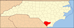 | |
| Towns | ||
| CDPs | ||
| Unincorporated communities | ||