National Register of Historic Places listings in Lenoir County, North Carolina
This list includes properties and districts listed on the National Register of Historic Places in Lenoir County, North Carolina. Click the "Map of all coordinates" link to the right to view an online map of all properties and districts with latitude and longitude coordinates in the table below.[1]

Current listings
- This National Park Service list is complete through NPS recent listings posted June 19, 2020.[2]
| [3] | Name on the Register[4] | Image | Date listed[5] | Location | City or town | Description |
|---|---|---|---|---|---|---|
| 1 | American Tobacco Company Prizery |  American Tobacco Company Prizery |
April 28, 2005 (#05000350) |
619 North Herritage Street 35°16′09″N 77°34′57″W |
Kinston | |
| 2 | Atlantic and North Carolina Railroad Freight Depot |  Atlantic and North Carolina Railroad Freight Depot |
November 8, 1989 (#89001768) |
East Blount Street between North Queen and North McLewean Streets 35°15′47″N 77°34′49″W |
Kinston | |
| 3 | Baptist Parsonage | 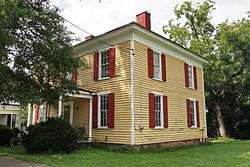 Baptist Parsonage |
November 8, 1989 (#89001767) |
211 South McLewean Street 35°15′28″N 77°34′48″W |
Kinston | |
| 4 | Robert L. Blalock House |  Robert L. Blalock House |
November 8, 1989 (#89001772) |
300 South McLewean Street 35°15′25″N 77°34′47″W |
Kinston | |
| 5 | B. W. Canady House |  B. W. Canady House |
November 8, 1989 (#89001771) |
600 North Queen Street 35°15′59″N 77°34′54″W |
Kinston | |
| 6 | Cedar Dell | 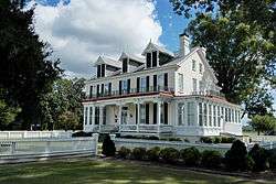 Cedar Dell |
August 26, 1971 (#71000600) |
Southeast of Falling Creek on SR 1338 35°15′17″N 77°41′20″W |
Falling Creek | |
| 7 | CSS NEUSE (Ironclad Gunboat) |  CSS NEUSE (Ironclad Gunboat) |
June 11, 2001 (#00000444) |
2612 West Vernon Avenue 35°16′01″N 77°37′18″W |
Kinston | |
| 8 | Herring House | October 25, 1973 (#73001356) |
Northwest of La Grange off SR 1503 35°19′44″N 77°48′22″W |
La Grange | ||
| 9 | Hill-Grainger Historic District |  Hill-Grainger Historic District |
November 8, 1989 (#89001764) |
Roughly bounded by Summit Avenue, North East Street, East and West Vernon Avenue, and North Heritage Street 35°16′17″N 77°34′47″W |
Kinston | |
| 10 | Hotel Kinston |  Hotel Kinston |
November 8, 1989 (#89001770) |
503 North Queen Street 35°15′54″N 77°34′52″W |
Kinston | |
| 11 | Imperial Tobacco Company Office Building | April 17, 2017 (#100000898) |
426 N. Heritage St. 35°15′54″N 77°34′59″W |
Kinston | ||
| 12 | Jesse Jackson House | June 24, 1971 (#71000602) |
Southeast of Kinston on NC 11 35°13′33″N 77°38′40″W |
Kinston | ||
| 13 | Kennedy Memorial Home Historic District |  Kennedy Memorial Home Historic District |
September 3, 2009 (#09000684) |
2557 Ceder Dell Lane 35°15′17″N 77°41′33″W |
Kinston | |
| 14 | Kinston Apartments | June 22, 2004 (#04000648) |
1313 McAdoo Street 35°16′40″N 77°34′42″W |
Kinston | ||
| 15 | Kinston Baptist-White Rock Presbyterian Church |  Kinston Baptist-White Rock Presbyterian Church |
November 8, 1989 (#89001773) |
516 Thompson Street 35°15′54″N 77°34′22″W |
Kinston | |
| 16 | Kinston Battlefield | 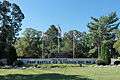 Kinston Battlefield |
November 30, 2006 (#06001104) |
1.5 miles (2.4 km) south of Kinston on US 258; 2 to 3 miles (3.2 to 4.8 km) south of Kinston on US 258; 3 miles (4.8 km) south of Kinston on NC 58; 4 miles (6.4 km) south of Kinston on US 258 35°13′41″N 77°36′36″W |
Kinston | |
| 17 | Kinston Fire Station-City Hall |  Kinston Fire Station-City Hall |
November 8, 1989 (#89001769) |
118 South Queen Street 35°15′34″N 77°34′53″W |
Kinston | |
| 18 | LaGrange Historic District | 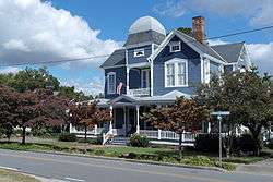 LaGrange Historic District |
May 11, 2000 (#00000458) |
Roughly bounded by North Caswell, East James, North Carey, East Washington, South Caswell, West Washington, and Forbes Streets 35°18′20″N 77°47′30″W |
La Grange | |
| 19 | LaGrange Presbyterian Church | 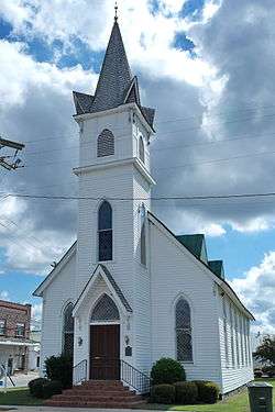 LaGrange Presbyterian Church |
August 14, 1986 (#86001646) |
201 South Caswell Street 35°18′17″N 77°47′21″W |
La Grange | |
| 20 | Lenoir County Courthouse |  Lenoir County Courthouse |
May 10, 1979 (#79001730) |
Queen and Kings Streets 35°15′30″N 77°34′25″W |
Kinston | |
| 21 | Midtown Motor Lodge |  Midtown Motor Lodge |
December 27, 2016 (#16000913) |
501 N. Herritage St. 35°15′56″N 77°34′58″W |
Kinston | |
| 22 | Mitchelltown Historic District | 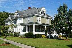 Mitchelltown Historic District |
November 8, 1989 (#89001766) |
Roughly bounded by West Vernon Avenue, North Heritage Street, West Blount Street, College Street, Atlantic Avenue, and Rhem Street 35°15′58″N 77°35′13″W |
Kinston | |
| 23 | Peebles House | 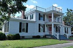 Peebles House |
August 26, 1971 (#71000603) |
109 East King Street 35°15′33″N 77°34′59″W |
Kinston | |
| 24 | Peoples Bank Building | November 8, 1998 (#89001774) |
242 S. Queen Street 35°15′27″N 77°34′51″W |
Kinston | ||
| 25 | Queen-Gordon Streets Historic District |  Queen-Gordon Streets Historic District |
November 8, 1989 (#89001765) |
Roughly N. Queen and Gordon Sts.; also roughly bounded by E. Blount, W. Blount, N. Heritage, W. North, and N. Queen Sts. 35°15′43″N 77°34′52″W |
Kinston | Second set of boundaries represents a boundary increase of June 3, 1994, the Kinston Commercial Historic District |
| 26 | Standard Drug No. 2 | December 1, 2014 (#14000987) |
100 South Queen Street 35°15′36″N 77°34′52″W |
Kinston | ||
| 27 | Sumrell and McCoy Building |  Sumrell and McCoy Building |
December 21, 1989 (#89002134) |
400 North Queen Street 35°15′49″N 77°34′54″W |
Kinston | |
| 28 | Trianon Historic District | November 8, 1989 (#89001763) |
Roughly East Gordon Street from North Tiffany to North Orion Streets and Water Street from North Vance to North Orion Streets 35°15′40″N 77°34′15″W |
Kinston | ||
| 29 | Tull-Worth-Holland Farm | September 22, 1992 (#92001260) |
NC 1579 north side, 0.5 miles (0.80 km) east of junction with NC 1578 35°18′54″N 77°35′30″W |
Kinston | ||
| 30 | Dempsey Wood House |  Dempsey Wood House |
August 26, 1971 (#71000601) |
Southwest of Falling Creek on SR 1324 35°13′51″N 77°43′28″W |
Kinston | |
| 31 | Wyse Fork Battlefield | July 10, 2017 (#100001301) |
SE of Kinston 35°13′26″N 77°31′47″W |
Kinston |
See also
| Wikimedia Commons has media related to National Register of Historic Places in Lenoir County, North Carolina. |
References
- The latitude and longitude information provided in this table was derived originally from the National Register Information System, which has been found to be fairly accurate for about 99% of listings. Some locations in this table may have been corrected to current GPS standards.
- "National Register of Historic Places: Weekly List Actions". National Park Service, United States Department of the Interior. Retrieved on June 19, 2020.
- Numbers represent an ordering by significant words. Various colorings, defined here, differentiate National Historic Landmarks and historic districts from other NRHP buildings, structures, sites or objects.
- "National Register Information System". National Register of Historic Places. National Park Service. April 24, 2008.
- The eight-digit number below each date is the number assigned to each location in the National Register Information System database, which can be viewed by clicking the number.

| Topics | |
|---|---|
| Lists by state |
|
| Lists by insular areas | |
| Lists by associated state | |
| Other areas | |
| Related | |
| |
Municipalities and communities of Lenoir County, North Carolina, United States | ||
|---|---|---|
| City | | |
| Towns | ||
| CDP | ||
| Unincorporated communities | ||
| Footnotes | ‡This populated place also has portions in an adjacent county or counties | |
This article is issued from Wikipedia. The text is licensed under Creative Commons - Attribution - Sharealike. Additional terms may apply for the media files.