National Register of Historic Places listings in Buncombe County, North Carolina
This list includes properties and districts listed on the National Register of Historic Places in Buncombe County, North Carolina. Click the "Map of all coordinates" link to the right to view an online map of all properties and districts with latitude and longitude coordinates in the table below.[1]
Current listings
- This National Park Service list is complete through NPS recent listings posted June 19, 2020.[2]
| [3] | Name on the Register[4] | Image | Date listed[5] | Location | City or town | Description |
|---|---|---|---|---|---|---|
| 1 | Judge Junius G. Adams House | October 5, 2001 (#01001077) |
11 Stuyvesant Rd. 35°32′09″N 82°32′14″W |
Biltmore Forest | ||
| 2 | Alexander Inn | May 31, 1984 (#84001932) |
Address Restricted |
Swannanoa | ||
| 3 | Mrs. Minnie Alexander Cottage | 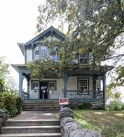 Mrs. Minnie Alexander Cottage |
December 21, 1989 (#89002135) |
218 Patton Ave. 35°35′34″N 82°33′40″W |
Asheville | |
| 4 | All Souls Episcopal Church and Parish House | .jpg) All Souls Episcopal Church and Parish House |
November 15, 1979 (#79001664) |
2 Angle St. 35°33′55″N 82°32′34″W |
Asheville | |
| 5 | Arcade Building | .jpg) Arcade Building |
May 19, 1976 (#76001306) |
Battery Park, Battle Sq. 35°35′44″N 82°33′24″W |
Asheville | |
| 6 | Asheville City Hall | .jpg) Asheville City Hall |
November 7, 1976 (#76001307) |
City County Plaza 35°35′44″N 82°32′55″W |
Asheville | |
| 7 | Asheville High School | .jpg) Asheville High School |
April 26, 1996 (#96000481) |
419 McDowell St. 35°34′17″N 82°33′08″W |
Asheville | |
| 8 | Asheville School | June 3, 1996 (#96000614) |
Roughly bounded by Patton Ave., the former Southern railroad line, Interstate 40, Sand Hill Rd., and the Malvern Hills subdivision 35°33′43″N 82°37′21″W |
Asheville | ||
| 9 | Asheville Transfer and Storage Company Building | Asheville Transfer and Storage Company Building |
April 26, 1979 (#79001665) |
192-194 Coxe Ave. 35°35′14″N 82°33′16″W |
Asheville | |
| 10 | B & B Motor Company Building |  B & B Motor Company Building |
April 26, 1979 (#79001666) |
84-94 Coxe Ave. 35°35′28″N 82°33′17″W |
Asheville | |
| 11 | Zebulon H. Baird House | April 30, 2009 (#09000261) |
460 Weaverville Rd. 35°39′57″N 82°35′03″W |
Weaverville | ||
| 12 | Clarence Barker Memorial Hospital | .jpg) Clarence Barker Memorial Hospital |
November 15, 1979 (#79001667) |
2-6 Reed St. 35°33′54″N 82°32′28″W |
Asheville | |
| 13 | Dr. John G. & Nannie H. Barrett Farm | May 8, 2013 (#13000245) |
75 Ox Creek Rd. 35°41′32″N 82°29′40″W |
Weaverville | ||
| 14 | Battery Park Hotel | .jpg) Battery Park Hotel |
July 14, 1977 (#77000990) |
Battle Sq. 35°35′49″N 82°32′19″W |
Asheville | |
| 15 | Bent Creek Campus of the Appalachian Forest Experiment Station | April 29, 1993 (#93000373) |
Brevard Rd. S of jct. with I-26 35°30′09″N 82°35′49″W |
Asheville | ||
| 16 | Biltmore Estate | 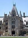 Biltmore Estate |
October 15, 1966 (#66000586) |
One Biltmore Plaza 35°34′03″N 82°32′34″W |
Asheville | |
| 17 | Biltmore Estate Office | .jpg) Biltmore Estate Office |
November 15, 1979 (#79001668) |
10 Biltmore Plaza 35°34′03″N 82°32′34″W |
Asheville | |
| 18 | Biltmore Hardware Building |  Biltmore Hardware Building |
August 21, 2003 (#03000800) |
28-32 Hendersonville Rd. 35°34′03″N 82°32′38″W |
Asheville | |
| 19 | Biltmore Hospital | .jpg) Biltmore Hospital |
September 1, 2005 (#05000938) |
14 All Souls Crecent 35°33′52″N 82°32′29″W |
Asheville | |
| 20 | Biltmore Industries, Inc. | Biltmore Industries, Inc. |
February 1, 1980 (#80002802) |
Grovewood Rd. 35°37′20″N 82°32′41″W |
Asheville | |
| 21 | Biltmore Shoe Store | 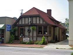 Biltmore Shoe Store |
November 15, 1979 (#79001669) |
8 Lodge St. 35°34′03″N 82°32′34″W |
Asheville | |
| 22 | Biltmore Village Commercial Buildings | 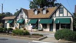 Biltmore Village Commercial Buildings |
November 15, 1979 (#79001670) |
Brook St. and Biltmore Plaza 35°34′03″N 82°32′34″W |
Asheville | |
| 23 | Biltmore Village Cottage District | .jpg) Biltmore Village Cottage District |
November 15, 1979 (#79001671) |
Swan St., All Souls Crescent and Boston Way 35°33′58″N 82°32′29″W |
Asheville | |
| 24 | Biltmore Village Cottages | November 15, 1979 (#79001672) |
18 Angle St. and 75 Hendersonville Rd. 35°33′58″N 82°32′38″W |
Asheville | Moved away from listed addresses in 1983.[6] Still listed as a historic place, but nomination form states "no longer on NR". | |
| 25 | Biltmore-Oteen Bank Building | .jpg) Biltmore-Oteen Bank Building |
November 15, 1979 (#79001673) |
12 Lodge St. 35°34′03″N 82°32′34″W |
Asheville | |
| 26 | Black Mountain College Historic District |  Black Mountain College Historic District |
October 5, 1982 (#82001281) |
SR 2468 35°37′59″N 82°22′17″W |
Black Mountain | |
| 27 | Black Mountain Downtown Historic District | 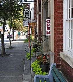 Black Mountain Downtown Historic District |
June 2, 2004 (#04000570) |
Black Mountain Ave., Sutton Ave., and Cherry, Broadway, and State Sts. 35°36′58″N 82°19′14″W |
Black Mountain | |
| 28 | Blake House |  Blake House |
August 30, 2010 (#10000600) |
150 Royal Pines Dr. 35°28′28″N 82°31′01″W |
Arden | |
| 29 | Bledsoe Building |  Bledsoe Building |
April 18, 2003 (#03000267) |
771-783 Haywood Rd. 35°34′44″N 82°35′40″W |
Asheville | |
| 30 | Blue Ridge Assembly Historic District | 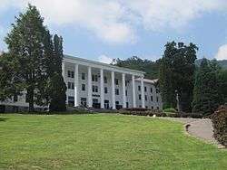 Blue Ridge Assembly Historic District |
September 17, 1979 (#79003327) |
S of Black Mountain on SR 2720 35°35′06″N 82°20′21″W |
Black Mountain | |
| 31 | William E. Breese, Sr., House | .jpg) William E. Breese, Sr., House |
April 28, 1980 (#80002803) |
674 Biltmore Ave. 35°34′23″N 82°32′44″W |
Asheville | |
| 32 | Brigman-Chambers House | June 2, 2004 (#04000573) |
NC 1003, 0.6 miles west of its junction with NC 2118 35°42′22″N 82°29′27″W |
Weaverville | ||
| 33 | Broadway Market Building | September 1, 2005 (#05000939) |
201 Broadway 35°36′05″N 82°33′22″W |
Asheville | Demolished.[7] | |
| 34 | William Jennings Bryan House | 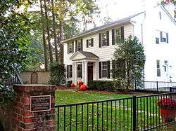 William Jennings Bryan House |
June 23, 1983 (#83001836) |
107 Evelyn Pl. 35°36′45″N 82°33′02″W |
Asheville | |
| 35 | Building at 130-132 Biltmore Avenue |  Building at 130-132 Biltmore Avenue |
April 26, 1979 (#79003323) |
130-132 Biltmore Ave. 35°35′25″N 82°33′04″W |
Asheville | |
| 36 | Building at 134-136½ Biltmore Avenue |  Building at 134-136½ Biltmore Avenue |
April 26, 1979 (#79003324) |
134-136½ Biltmore Ave. 35°35′25″N 82°33′04″W |
Asheville | |
| 37 | Building at 140 Biltmore Avenue |  Building at 140 Biltmore Avenue |
April 26, 1979 (#79003325) |
140 Biltmore Ave. 35°35′25″N 82°33′04″W |
Asheville | |
| 38 | Buncombe County Boys' Training School | September 30, 1997 (#97001197) |
177 Erwin Hills Rd. 35°37′14″N 82°37′23″W |
Asheville | ||
| 39 | Buncombe County Courthouse | .jpg) Buncombe County Courthouse |
May 10, 1979 (#79001674) |
College and Davidson Sts. 35°35′45″N 82°32′55″W |
Asheville | |
| 40 | Camp Academy |  Camp Academy |
September 19, 1985 (#85002421) |
NC 63 35°39′22″N 82°42′52″W |
Leicester | |
| 41 | William Nelson Camp, Jr., House | 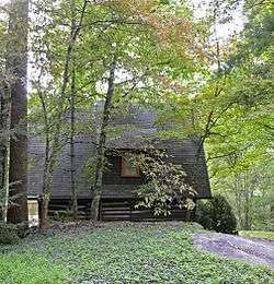 William Nelson Camp, Jr., House |
December 17, 1998 (#98001530) |
92 Flat Top Mountain Rd. 35°32′56″N 82°23′31″W |
Fairview | |
| 42 | Carter-Swain House | July 2, 1987 (#87001114) |
E side SR 2162, N of jct. with SR 2163 35°47′24″N 82°29′31″W |
Democrat | ||
| 43 | Chestnut Hill Historic District |  Chestnut Hill Historic District |
March 17, 1983 (#83001837) |
Roughly bounded by Hillside, Washington, Broad, Hollywood, and Orchards Sts. and Merrimon Ave. 35°36′13″N 82°32′55″W |
Asheville | |
| 44 | James Madison and Leah Arcouet Chiles House | 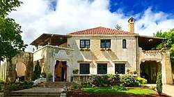 James Madison and Leah Arcouet Chiles House |
January 25, 2018 (#100002045) |
21 Chiles Ave. 35°34′34″N 82°32′04″W |
Asheville | |
| 45 | Church of St. Lawrence | .jpg) Church of St. Lawrence |
March 24, 1978 (#78001933) |
97 Haywood St. 35°35′51″N 82°33′23″W |
Asheville | |
| 46 | Church of the Redeemer |  Church of the Redeemer |
September 19, 1985 (#85002419) |
1202 Riverside Dr. 35°37′28″N 82°35′33″W |
Asheville | |
| 47 | Claxton School |  Claxton School |
June 4, 1992 (#92000671) |
241 Merrimon Ave. 35°36′28″N 82°33′13″W |
Asheville | |
| 48 | Clingman Avenue Historic District |  Clingman Avenue Historic District |
June 9, 2004 (#04000583) |
Roughly along Clingman Ave., from Hillard Ave. to Haywood Ave. 35°35′24″N 82°33′48″W |
Asheville | |
| 49 | Conabeer Chrysler Building |  Conabeer Chrysler Building |
April 26, 1979 (#79001675) |
162-164 Coxe Ave. 35°35′18″N 82°33′17″W |
Asheville | |
| 50 | Demens-Rumbough-Crawley House |  Demens-Rumbough-Crawley House |
June 1, 1982 (#82003435) |
31 Park Ave. 35°35′21″N 82°33′59″W |
Asheville | |
| 51 | Dougherty Heights Historic District | January 14, 2011 (#10001132) |
Church St., Connally St., and North Dougherty St., Laurel Circle, Prospect St., and New Bern Ave. 35°37′03″N 82°19′26″W |
Black Mountain | ||
| 52 | Downtown Asheville Historic District | Downtown Asheville Historic District |
April 26, 1979 (#79001676) |
Roughly bounded by 1240 Valley St., Hilliard Ave., and Broad Ave.; also 60 and 64 Biltmore Ave.; also Church St. and Ravenscroft Dr.; also 76-129 Biltmore Ave., 64 Carter St., 11-23 Grove St., 14-44 N. and 12-25 S. French Broad Ave. 35°35′42″N 82°33′12″W |
Asheville | Second, third, and fourth sets of boundaries represent boundary increases of May 25, 1989, August 23, 1990, and (increase-and-decrease) December 28, 2011 |
| 53 | E.D. Latta Nurses' Residence | 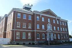 E.D. Latta Nurses' Residence |
April 26, 1979 (#79001677) |
159 Woodfin St. 35°35′58″N 82°32′48″W |
Asheville | |
| 54 | Eliada Home | April 22, 1993 (#93000314) |
2 Compton Dr. 35°36′08″N 82°37′08″W |
Asheville | ||
| 55 | Joseph P. Eller House | August 11, 2004 (#04000826) |
494 Clarks' Chapel Rd. 35°43′51″N 82°34′20″W |
Weaverville | ||
| 56 | Douglas Ellington House | 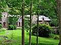 Douglas Ellington House |
October 16, 1986 (#86002881) |
583 Chunns Cove Rd. 35°37′07″N 82°31′24″W |
Asheville | |
| 57 | Bruce A. and June L. Elmore Lustron House |  Bruce A. and June L. Elmore Lustron House |
August 27, 2013 (#13000635) |
70 Hampden Rd. 35°35′01″N 82°29′48″W |
Asheville | |
| 58 | Engadine | September 24, 2001 (#01001027) |
US 19/23, 0.3 miles E of Haywood 35°32′20″N 82°45′43″W |
Candler | ||
| 59 | Fire Station Number 4 |  Fire Station Number 4 |
April 6, 2000 (#00000336) |
300 Merrimon Ave. 35°36′32″N 82°33′17″W |
Asheville | |
| 60 | First Baptist Church |  First Baptist Church |
July 13, 1976 (#76001308) |
Oak and Woodfin Sts. 35°35′57″N 82°32′52″W |
Asheville | |
| 61 | Foster's Log Cabin Court | May 1, 2017 (#100000939) |
330 and 332 Weaverville Rd. 35°39′38″N 82°34′55″W |
Woodfin | ||
| 62 | Grove Park Historic District | 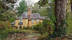 Grove Park Historic District |
April 13, 1989 (#89000247) |
Roughly bounded by Evelyn Pl., Macon Ave., Howland Rd., Woodland Rd., Canterbury Ln., Charlotte St., and Murdock Ave.; also roughly Kimberly Ave. from Maywood St. to north of Evelyn Pl., including Grove Park Inn Country Club 35°36′38″N 82°32′45″W |
Asheville | Second set of boundaries represents a boundary increase of December 18, 1990 |
| 63 | Grove Park Inn |  Grove Park Inn |
April 3, 1973 (#73001295) |
Macon Ave. 35°37′15″N 82°31′26″W |
Asheville | |
| 64 | Rafael Guastavino, Sr., Estate |  Rafael Guastavino, Sr., Estate |
July 13, 1989 (#89000849) |
NC 9, 0.8 miles south its junction with SR 2713 35°35′51″N 82°18′35″W |
Black Mountain | |
| 65 | Gunston Hall | October 24, 1991 (#91001505) |
324 Vanderbilt Rd. 35°32′50″N 82°32′11″W |
Biltmore Forest | ||
| 66 | Intheoaks | April 10, 1991 (#91000361) |
510 Vance Ave. 35°36′40″N 82°19′40″W |
Black Mountain | ||
| 67 | Thomas Jarrett House |  Thomas Jarrett House |
January 21, 1994 (#93001535) |
46 Louisiana Ave. 35°34′47″N 82°35′28″W |
Asheville | |
| 68 | Kenilworth Inn | .jpg) Kenilworth Inn |
December 31, 2001 (#01001423) |
60 Caledonia Rd. 35°34′20″N 82°32′27″W |
Asheville | |
| 69 | John A. Lanning House | September 23, 1982 (#82003437) |
W of Fairview on SR 3128 35°31′15″N 82°25′56″W |
Fairview | ||
| 70 | Manor and Cottages |  Manor and Cottages |
January 26, 1978 (#78001934) |
265 Charlotte St. 35°36′29″N 82°32′33″W |
Asheville | |
| 71 | Dr. Cireo McAfee McCracken House | September 1, 1995 (#95001066) |
1384 Charlotte Highway 35°31′28″N 82°24′34″W |
Fairview | ||
| 72 | McGeahy Building | .jpg) McGeahy Building |
November 15, 1979 (#79001679) |
7½ Biltmore Plaza 35°34′03″N 82°32′34″W |
Asheville | |
| 73 | George A. Mears House |  George A. Mears House |
April 26, 1979 (#79001678) |
137 Biltmore Ave. 35°35′25″N 82°33′04″W |
Asheville | |
| 74 | Monte Vista Hotel | 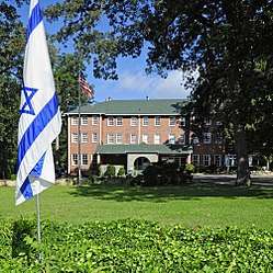 Monte Vista Hotel |
April 30, 2008 (#08000366) |
308 W. State St. 35°36′50″N 82°19′37″W |
Black Mountain | |
| 75 | Montford Area Historic District |  Montford Area Historic District |
November 25, 1977 (#77000991) |
Irregular pattern along Montford Ave. 35°36′10″N 82°33′53″W |
Asheville | |
| 76 | Municipal Golf Course | 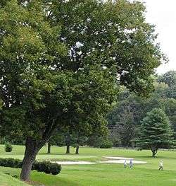 Municipal Golf Course |
April 20, 2005 (#05000318) |
226 Fairway Dr. 35°34′45″N 82°30′08″W |
Asheville | |
| 77 | North Carolina Electrical Power Company Electric Generating Plant | June 25, 1999 (#99000754) |
2024 Riverside Dr. 35°38′25″N 82°35′53″W |
Woodfin | ||
| 78 | Norwood Park Historic District |  Norwood Park Historic District |
August 29, 2008 (#08000815) |
Bounded roughly on the west and south by Murdock St.; on the north by Woodward Ave.; and on the east by Norwood Ave. 35°36′56″N 82°33′09″W |
Asheville | |
| 79 | Oteen Veterans Administration Hospital Historic District |  Oteen Veterans Administration Hospital Historic District |
November 20, 1985 (#85003529) |
Northern side of U.S. Route 70 35°35′27″N 82°29′05″W |
Asheville | |
| 80 | Ottari Sanitarium |  Ottari Sanitarium |
October 16, 1986 (#86002876) |
491 Kimberly Ave. 35°37′45″N 82°32′51″W |
Asheville | |
| 81 | Overlook | 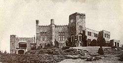 Overlook |
October 22, 1980 (#80002804) |
710 Town Mountain Rd. 35°36′40″N 82°32′04″W |
Asheville | |
| 82 | Proximity Park Historic District |  Proximity Park Historic District |
October 8, 2008 (#08000974) |
Roughly bounded by Macon Ave., Howland Rd., Woodlink Rd., Charlotte St., and Sunset Trail 35°36′52″N 82°32′33″W |
Asheville | |
| 83 | Thomas Wadley Raoul House | November 28, 2006 (#06001105) |
394 Vanderbilt Rd. 35°32′03″N 82°32′24″W |
Asheville | ||
| 84 | Ravenscroft School |  Ravenscroft School |
December 12, 1978 (#78001935) |
29 Ravenscroft Dr. 35°35′29″N 82°33′15″W |
Asheville | |
| 85 | Samuel Harrison Reed House |  Samuel Harrison Reed House |
November 15, 1979 (#79001680) |
119 Dodge St. 35°33′51″N 82°32′22″W |
Asheville | |
| 86 | Reynolds House | September 13, 1984 (#84001934) |
100 Reynolds Hts. 35°38′37″N 82°34′41″W |
Asheville | ||
| 87 | Dr. Carl V. Reynolds House | August 19, 1982 (#82003436) |
86 Edgemont Rd. 35°36′52″N 82°32′32″W |
Asheville | ||
| 88 | Richbourg Motors Building |  Richbourg Motors Building |
April 26, 1979 (#79001681) |
50 Coxe Ave. 35°35′32″N 82°33′17″W |
Asheville | |
| 89 | Richmond Hill House | August 16, 1977 (#77000992) |
45 Richmond Hill Rd. 35°36′40″N 82°34′50″W |
Asheville | ||
| 90 | Riverside Industrial Historic District |  Riverside Industrial Historic District |
August 11, 2004 (#04000825) |
Roughly bounded by Clingman Ave., Lyman St., Roberts St., and Riverside Dr. 35°35′10″N 82°34′01″W |
Asheville | |
| 91 | S And W Cafeteria | .jpg) S And W Cafeteria |
March 28, 1977 (#77000993) |
Patton Ave. 35°35′40″N 82°33′14″W |
Asheville | |
| 92 | Sawyer Motor Company Building |  Sawyer Motor Company Building |
April 26, 1979 (#79001682) |
100 Coxe Ave. 35°35′26″N 82°33′17″W |
Asheville | |
| 93 | Schoenberger Hall | 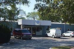 Schoenberger Hall |
April 26, 1979 (#79001683) |
60 Ravenscroft Dr. 35°35′25″N 82°33′12″W |
Asheville | Destroyed[8] |
| 94 | Seven Oaks |  Seven Oaks |
August 13, 2015 (#15000528) |
82 Westwood Pl. 35°34′53″N 82°34′45″W |
Asheville | |
| 95 | Sherrill's Inn | 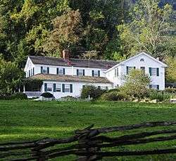 Sherrill's Inn |
April 16, 1975 (#75001244) |
2.5 miles south of Fairview off U.S. Route 74 35°29′36″N 82°21′59″W |
Fairview | |
| 96 | Richard Sharp Smith House | 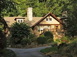 Richard Sharp Smith House |
January 22, 2009 (#08001361) |
655 Chunns Cove Rd. 35°37′07″N 82°31′28″W |
Asheville | |
| 97 | Whitford G. Smith House | .jpg) Whitford G. Smith House |
May 4, 2005 (#05000375) |
263 Haywood St. 35°35′41″N 82°33′43″W |
Asheville | |
| 98 | Smith-McDowell House |  Smith-McDowell House |
August 1, 1975 (#75001243) |
283 Victoria Rd. 35°34′23″N 82°33′18″W |
Asheville | |
| 99 | South Montreat Road Historic District | December 27, 2010 (#10001056) |
Along Montreat Rd., 102 1st St., 100 3rd St., 100 9th St., and 101 Beech St. 35°37′23″N 82°19′15″W |
Black Mountain | ||
| 100 | Southern Railway Passenger Depot | Southern Railway Passenger Depot |
November 15, 1979 (#79001684) |
1 Biltmore Plaza 35°34′03″N 82°32′34″W |
Asheville | |
| 101 | Spinning Wheel |  Spinning Wheel |
July 28, 1999 (#99000913) |
1096 Hendersonville Rd. 35°32′07″N 82°31′41″W |
Asheville | |
| 102 | St. Luke's Episcopal Church |  St. Luke's Episcopal Church |
September 30, 1997 (#97001198) |
219 Chunn's Cove Rd. 35°36′07″N 82°31′53″W |
Asheville | |
| 103 | St. Mary's Church | 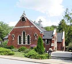 St. Mary's Church |
December 23, 1994 (#94001476) |
337 Charlotte St. 35°36′39″N 82°32′42″W |
Asheville | |
| 104 | St. Matthias Episcopal Church | .JPG) St. Matthias Episcopal Church |
May 10, 1979 (#79001685) |
Valley St. 35°35′30″N 82°32′54″W |
Asheville | |
| 105 | Sunset Terrace Historic District | December 16, 2005 (#05001411) |
9-48 Sunset Terrace 35°36′58″N 82°32′30″W |
Asheville | ||
| 106 | Thomas Chapel A.M.E. Zion Church | 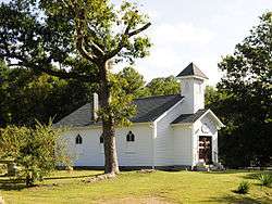 Thomas Chapel A.M.E. Zion Church |
April 30, 2009 (#09000262) |
300 Cragmont Rd. 35°37′09″N 82°21′20″W |
Black Mountain | |
| 107 | Kate and Charles Noel Vance House | December 20, 2016 (#16000876) |
178 Sunset Dr. 35°36′47″N 82°18′43″W |
Black Mountain | ||
| 108 | Weaverville United Methodist Church |  Weaverville United Methodist Church |
March 1, 1996 (#96000195) |
85 N. Main St. 35°41′57″N 82°33′37″W |
Weaverville | |
| 109 | West Asheville End of Car Line Historic District |  West Asheville End of Car Line Historic District |
August 9, 2006 (#06000691) |
Both sides of Haywood Rd. from 715 to 814 and 7-9 Brevard Rd. 35°34′41″N 82°35′39″W |
Asheville | |
| 110 | West Asheville-Aycock School Historic District | 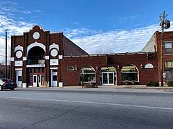 West Asheville-Aycock School Historic District |
August 23, 2006 (#06000718) |
401-441 Haywood Rd. 35°34′42″N 82°34′53″W |
Asheville | Boundary increase 2014-09-03 |
| 111 | Thomas Wolfe House | 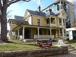 Thomas Wolfe House |
November 11, 1971 (#71000572) |
48 Spruce St. 35°35′51″N 82°32′43″W |
Asheville | |
| 112 | Young Men's Institute Building | .jpg) Young Men's Institute Building |
July 14, 1977 (#77000994) |
Market and Eagle Sts. 35°35′38″N 82°33′01″W |
Asheville | |
| 113 | Zealandia |  Zealandia |
March 14, 1977 (#77000995) |
40 Vance Gap Rd. 35°35′47″N 82°32′21″W |
Asheville |
See also
| Wikimedia Commons has media related to National Register of Historic Places in Buncombe County, North Carolina. |
References
- The latitude and longitude information provided in this table was derived originally from the National Register Information System, which has been found to be fairly accurate for about 99% of listings. Some locations in this table may have been corrected to current GPS standards.
- "National Register of Historic Places: Weekly List Actions". National Park Service, United States Department of the Interior. Retrieved on June 19, 2020.
- Numbers represent an ordering by significant words. Various colorings, defined here, differentiate National Historic Landmarks and historic districts from other NRHP buildings, structures, sites or objects.
- "National Register Information System". National Register of Historic Places. National Park Service. April 24, 2008.
- The eight-digit number below each date is the number assigned to each location in the National Register Information System database, which can be viewed by clicking the number.
- North Carolina Department of Natural and Cultural Resources
- http://www.hpo.ncdcr.gov/NR-PDFs.pdf
- "North Carolina Listings in the National Register of Historic Places by County". North Carolina State Historic Preservation Office. 22 October 2008. Archived from the original on 30 November 2012. Retrieved 14 July 2009.

| Topics | |
|---|---|
| Lists by state |
|
| Lists by insular areas | |
| Lists by associated state | |
| Other areas | |
| Related | |
| |
Municipalities and communities of Buncombe County, North Carolina, United States | ||
|---|---|---|
| City | | |
| Towns | ||
| CDPs | ||
| Unincorporated communities | ||
This article is issued from Wikipedia. The text is licensed under Creative Commons - Attribution - Sharealike. Additional terms may apply for the media files.