National Register of Historic Places listings in Carteret County, North Carolina
This list includes properties and districts listed on the National Register of Historic Places in Carteret County, North Carolina. Click the "Map of all coordinates" link to the right to view a Google map of all properties and districts with latitude and longitude coordinates in the table below.[1]

Current listings
- This National Park Service list is complete through NPS recent listings posted June 19, 2020.[2]
| [3] | Name on the Register[4] | Image | Date listed[5] | Location | City or town | Description |
|---|---|---|---|---|---|---|
| 1 | Beaufort Historic District |  Beaufort Historic District |
May 6, 1974 (#74001331) |
Roughly bounded by Beaufort Channel, Pine and Fulford Sts., and Taylors Creek 34°42′46″N 76°40′08″W |
Beaufort | |
| 2 | HMT BEDFORDSHIRE (shipwreck and remains) | July 31, 2015 (#15000421) |
Offshore Beaufort 34°10′00″N 76°41′00″W |
Beaufort | ||
| 3 | Cape Lookout Coast Guard Station | 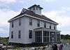 Cape Lookout Coast Guard Station |
February 1, 1989 (#88003436) |
Cape Lookout 34°36′11″N 76°32′17″W |
Core Banks | |
| 4 | Cape Lookout Light Station | 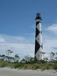 Cape Lookout Light Station |
October 18, 1972 (#72000097) |
On Core Banks 34°37′24″N 76°31′30″W |
Core Banks | |
| 5 | Cape Lookout Village Historic District |  Cape Lookout Village Historic District |
June 3, 2000 (#00000692) |
Cape Lookout from Lighthouse to Coast Guard St.; bounded by ocean and a concrete road, and concrete road across Bight 34°36′45″N 76°32′06″W |
Core Banks | |
| 6 | Carteret County Home | 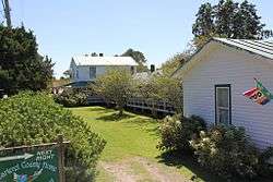 Carteret County Home |
December 20, 1984 (#84000528) |
NC 101 34°43′52″N 76°39′00″W |
Beaufort | |
| 7 | Fort Macon | 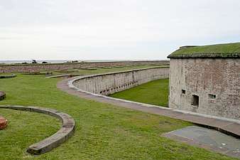 Fort Macon |
February 26, 1970 (#70000445) |
Bogue Point, on Fort Macon Rd., 4 miles E of Atlantic Beach 34°41′45″N 76°40′45″W |
Atlantic Beach | |
| 8 | Gibbs House | 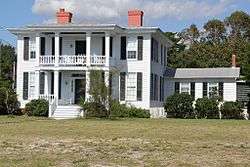 Gibbs House |
March 14, 1973 (#73001302) |
903 Front St. 34°42′50″N 76°39′34″W |
Beaufort | |
| 9 | Jacob Henry House | 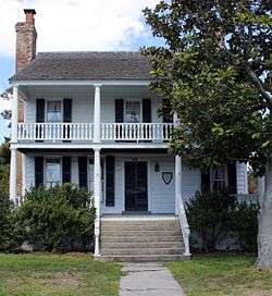 Jacob Henry House |
May 7, 1973 (#73001303) |
229 Front St. 34°43′04″N 76°40′04″W |
Beaufort | |
| 10 | Morehead City Historic District | _1.jpg) Morehead City Historic District |
April 18, 2003 (#03000266) |
Roughly along Fisher St. and Bridges St., from N. 5th St. to N. 12th St. 34°43′21″N 76°42′51″W |
Morehead City | |
| 11 | Morehead City Municipal Building | 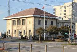 Morehead City Municipal Building |
August 11, 2004 (#04000828) |
202 S. Eighth St. 34°43′13″N 76°42′48″W |
Morehead City | |
| 12 | Old Burying Ground | 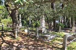 Old Burying Ground |
April 8, 1974 (#74001332) |
Bounded by Ann, Craven, and Broad Sts. 34°43′07″N 76°39′51″W |
Beaufort | |
| 13 | Portsmouth Village |  Portsmouth Village |
November 29, 1978 (#78000267) |
N end of Core Banks 35°04′04″N 76°03′43″W |
Portsmouth | |
| 14 | Queen Anne's Revenge | 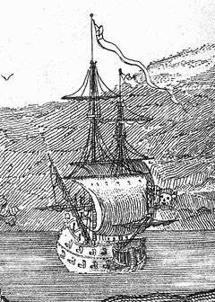 Queen Anne's Revenge |
March 9, 2004 (#04000148) |
Address Restricted |
Atlantic Beach | Wreck of a famous pirate ship |
| 15 | Salter-Battle Hunting and Fishing Lodge | May 5, 2005 (#05000381) |
Sheep Island 35°03′28″N 76°04′49″W |
Ocracoke | ||
| 16 | U-352 (submarine) shipwreck and remains |  U-352 (submarine) shipwreck and remains |
November 12, 2015 (#15000804) |
Offshore |
Beaufort |
See also
| Wikimedia Commons has media related to National Register of Historic Places in Carteret County, North Carolina. |
References
- The latitude and longitude information provided in this table was derived originally from the National Register Information System, which has been found to be fairly accurate for about 99% of listings. Some locations in this table may have been corrected to current GPS standards.
- "National Register of Historic Places: Weekly List Actions". National Park Service, United States Department of the Interior. Retrieved on June 19, 2020.
- Numbers represent an ordering by significant words. Various colorings, defined here, differentiate National Historic Landmarks and historic districts from other NRHP buildings, structures, sites or objects.
- "National Register Information System". National Register of Historic Places. National Park Service. April 24, 2008.
- The eight-digit number below each date is the number assigned to each location in the National Register Information System database, which can be viewed by clicking the number.

| Topics | |
|---|---|
| Lists by state |
|
| Lists by insular areas | |
| Lists by associated state | |
| Other areas | |
| Related | |
| |
Municipalities and communities of Carteret County, North Carolina, United States | ||
|---|---|---|
| Towns | | |
| CDPs | ||
| Other unincorporated communities | ||
| Ghost towns | ||
This article is issued from Wikipedia. The text is licensed under Creative Commons - Attribution - Sharealike. Additional terms may apply for the media files.