National Register of Historic Places listings in Swain County, North Carolina
This list includes properties and districts listed on the National Register of Historic Places in Swain County, North Carolina. Click the "Map of all coordinates" link to the right to view an online map of all properties and districts with latitude and longitude coordinates in the table below.[1]
Current listings
- This National Park Service list is complete through NPS recent listings posted June 19, 2020.[2]
| [3] | Name on the Register | Image | Date listed[4] | Location | City or town | Description |
|---|---|---|---|---|---|---|
| 1 | Cheoah Hydroelectric Development | 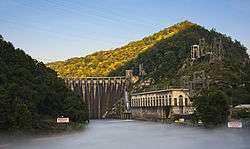 Cheoah Hydroelectric Development |
May 21, 2004 (#04000464) |
1512 Tapoca Rd., NC 129 35°27′00″N 83°56′10″W |
Robbinsville | Extends into Graham County |
| 2 | Clingmans Dome Observation Tower | 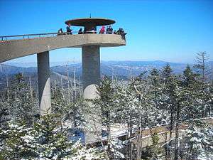 Clingmans Dome Observation Tower |
August 15, 2012 (#12000515) |
Terminus of Clingmans Dome Rd. 35°33′46″N 83°29′55″W |
Bryson City | Extends into Sevier County, Tennessee |
| 3 | Frye-Randolph House and Fryemont Inn |  Frye-Randolph House and Fryemont Inn |
February 18, 1983 (#83001919) |
Fryemont Rd. 35°25′29″N 83°26′42″W |
Bryson City | |
| 4 | Governors Island |  Governors Island |
June 4, 1973 (#73002239) |
U.S. Route 19 east of Bryson City[5] 35°26′13″N 83°24′16″W |
Bryson City | Also known as "Kituhwa"[6] |
| 5 | Hall Cabin | 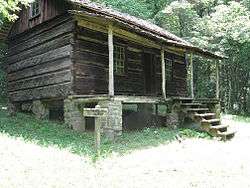 Hall Cabin |
January 30, 1976 (#76000162) |
15 miles northeast of Fontana in Great Smoky Mountains National Park 35°31′12″N 83°40′46″W |
Fontana | Also known as the J.H. Kress Cabin |
| 6 | Abel Hyatt House |  Abel Hyatt House |
March 22, 1991 (#91000340) |
Eastern side of NC 1168, 0.2 miles north of its junction with NC 1191 35°26′15″N 83°23′47″W |
Bryson City | |
| 7 | Mingus Mill |  Mingus Mill |
November 29, 2016 (#16000808) |
Newfound Gap Rd., Great Smoky Mountains National Park 35°31′12″N 83°18′35″W |
Cherokee | |
| 8 | Nununyi Mound and Village Site | January 22, 1980 (#80002901) |
Between Acquoni Rd. and the Oconaluftee River, north of Cherokee[5] 35°29′40″N 83°18′39″W |
Cherokee | Site 31SW3[7] | |
| 9 | Oconaluftee Archeological District | February 19, 1982 (#82001715) |
Address Restricted |
Cherokee | ||
| 10 | Oconaluftee Baptist Church | _Baptist_Church%2C_Cherokee%2C_NC.jpg) Oconaluftee Baptist Church |
January 1, 1976 (#76000163) |
6 miles north of Cherokee on U.S. Route 441 in Great Smoky Mountains National Park 35°33′13″N 83°18′31″W |
Cherokee | Part of Smokemont ghost town |
| 11 | Oconaluftee Ranger Station | %2C_Cherokee%2C_NC.jpg) Oconaluftee Ranger Station |
November 29, 2016 (#16000809) |
Newfound Gap Rd., Great Smoky Mountains National Park 35°30′47″N 83°18′23″W |
Cherokee | |
| 12 | Swain County Courthouse |  Swain County Courthouse |
May 10, 1979 (#79001752) |
Main and Fry Sts. 35°25′40″N 83°26′44″W |
Bryson City |
See also
| Wikimedia Commons has media related to National Register of Historic Places in Swain County, North Carolina. |
References
- The latitude and longitude information provided in this table was derived originally from the National Register Information System, which has been found to be fairly accurate for about 99% of listings. Some locations in this table may have been corrected to current GPS standards.
- "National Register of Historic Places: Weekly List Actions". National Park Service, United States Department of the Interior. Retrieved on June 19, 2020.
- Numbers represent an ordering by significant words. Various colorings, defined here, differentiate National Historic Landmarks and historic districts from other NRHP buildings, structures, sites or objects.
- The eight-digit number below each date is the number assigned to each location in the National Register Information System database, which can be viewed by clicking the number.
- Master Site Record, Research Laboratories of Archaeology, University of North Carolina at Chapel Hill, n.d. Accessed 2014-06-23.
- "National Register Information System". National Register of Historic Places. National Park Service. July 9, 2010.
- Davis, R.P. Stephen, Jr., et al. "An Abbreviated NAGPRA Inventory of theNorth Carolina Archaeological Collection", University of North Carolina at Chapel Hill, 1998, 7. Accessed 2014-06-23.

| Topics | |
|---|---|
| Lists by state |
|
| Lists by insular areas | |
| Lists by associated state | |
| Other areas | |
| Related | |
| |
Municipalities and communities of Swain County, North Carolina, United States | ||
|---|---|---|
| Town | | |
| CDP | ||
| Unincorporated communities | ||
| Indian reservation | ||
| Footnotes | ‡This populated place also has portions in an adjacent county or counties | |
This article is issued from Wikipedia. The text is licensed under Creative Commons - Attribution - Sharealike. Additional terms may apply for the media files.