National Register of Historic Places listings in New Hanover County, North Carolina
This list includes properties and districts listed on the National Register of Historic Places in New Hanover County, North Carolina. Click the "Map of all coordinates" link to the right to view a Google map of all properties and districts with latitude and longitude coordinates in the table below.[1]
Current listings
- This National Park Service list is complete through NPS recent listings posted June 19, 2020.[2]
| [3] | Name on the Register[4] | Image | Date listed[5] | Location | City or town | Description |
|---|---|---|---|---|---|---|
| 1 | Audubon Trolley Station | .JPG) Audubon Trolley Station |
August 5, 1993 (#93000736) |
Junction of Park Ave. and Audubon Boulevard 34°12′55″N 77°53′47″W |
Wilmington | |
| 2 | Bradley-Latimer Summer House |  Bradley-Latimer Summer House |
July 20, 1987 (#87001181) |
Southern side of NC 1411 east of its junction with U.S. Route 76 34°12′55″N 77°49′52″W |
Wrightsville Beach | |
| 3 | Brookwood Historic District |  Brookwood Historic District |
December 2, 2014 (#14000990) |
Roughly bounded by Market St., Keaton Ave., Burnt Mill Creek, and Wallace Park 34°14′13″N 77°55′02″W |
Wilmington | |
| 4 | Cape Fear Civil War Shipwreck Discontiguous District | December 23, 1985 (#85003195) |
Multiple locations off the North Carolina coast |
Kure Beach, Wrightsville Beach and Wilmington Beach | ||
| 5 | Carolina Heights Historic District |  Carolina Heights Historic District |
July 29, 1999 (#99000317) |
Roughly bounded by Market St., 13th St., Rankin St., and 19th St.; also the 1200 block of Market St. and the 100 and 200 blocks of N. 13th St. 34°14′21″N 77°55′44″W |
Wilmington | Second set of addresses represents a boundary increase of November 30, 1999 |
| 6 | Carolina Place Historic District | 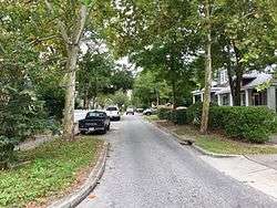 Carolina Place Historic District |
August 31, 1992 (#92001086) |
Bounded by Market St., Wallace Park, Gibson Ave., Wrightsville Ave., and S. 18th St. 34°14′06″N 77°55′24″W |
Wilmington | |
| 7 | City Hall/Thalian Hall | _2.JPG) City Hall/Thalian Hall |
April 3, 1970 (#70000464) |
100 N. 3rd. St. 34°14′14″N 77°56′48″W |
Wilmington | |
| 8 | Delgrado School |  Delgrado School |
October 20, 2001 (#01001135) |
1930 Colwell Ave. 34°13′45″N 77°55′21″W |
Wilmington | |
| 9 | Federal Building and Courthouse | _3.JPG) Federal Building and Courthouse |
May 2, 1974 (#74001363) |
N. Water between Market and Princess St. 34°14′07″N 77°57′00″W |
Wilmington | |
| 10 | Fort Fisher | 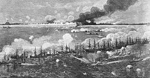 Fort Fisher |
October 15, 1966 (#66000595) |
18 miles south of Wilmington on U.S. Route 421 33°57′57″N 77°55′37″W |
Wilmington | |
| 11 | Gabriel's Landing | 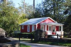 Gabriel's Landing |
May 7, 2008 (#08000382) |
1005 Airlie Rd. 34°12′49″N 77°49′18″W |
Wilmington | |
| 12 | Homesite (31Nh95**1) | March 13, 1997 (#97000165) |
Address Restricted |
Carolina Beach | ||
| 13 | William Hooper School (Former) | .JPG) William Hooper School (Former) |
March 12, 1998 (#98000231) |
410 Meares St. 34°13′17″N 77°56′34″W |
Wilmington | |
| 14 | Joy Lee Apartment Building and Annex |  Joy Lee Apartment Building and Annex |
April 3, 1997 (#97000256) |
317 Carolina Beach Ave., N. 34°02′14″N 77°53′30″W |
Carolina Beach | |
| 15 | Market Street Mansion District | .JPG) Market Street Mansion District |
April 21, 1975 (#75001284) |
1704, 1705, 1710, and 1713 Market St. 34°14′12″N 77°55′38″W |
Wilmington | |
| 16 | Masonboro Sound Historic District | October 22, 1992 (#92001334) |
Eastern side of Magnolia Dr. and 7301-7601, 7424, and 7506 Masonboro Sound Rd. 34°10′40″N 77°50′45″W |
Wilmington | ||
| 17 | Mount Lebanon Chapel and Cemetery |  Mount Lebanon Chapel and Cemetery |
October 16, 1986 (#86002879) |
NC 1411 34°12′50″N 77°49′35″W |
Wrightsville Beach | |
| 18 | Newton Homesite and Cemetery | 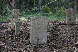 Newton Homesite and Cemetery |
March 13, 1997 (#97000166) |
Off Dow Road South[6] 34°01′05″N 77°54′47″W |
Carolina Beach | |
| 19 | James D. and Frances Sprunt Cottage | 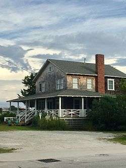 James D. and Frances Sprunt Cottage |
December 18, 2013 (#13000935) |
207 N. Lumina Ave. 34°12′39″N 77°47′40″W |
Wrightsville Beach | |
| 20 | Sunset Park Historic District | .JPG) Sunset Park Historic District |
December 10, 2003 (#03001265) |
Roughly bounded by Carolina Beach Rd., Southern Boulevard, Burnett Boulevard, and Sunset Ave. 34°12′14″N 77°56′45″W |
Wilmington | |
| 21 | Tinga Nursery | 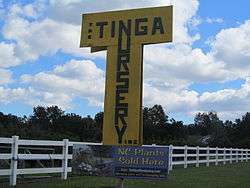 Tinga Nursery |
October 4, 2000 (#00001185) |
U.S. Route 117, 0.62 miles north of its junction with NC 132 34°17′55″N 77°55′04″W |
Wrightsboro | |
| 22 | USS NORTH CAROLINA (BB-55) National Historic Landmark |  USS NORTH CAROLINA (BB-55) National Historic Landmark |
November 10, 1982 (#82004893) |
Western bank of the Cape Fear River 34°14′11″N 77°57′16″W |
Wilmington | |
| 23 | U.S.S. PETERHOFF | August 6, 1975 (#75001283) |
Address Restricted |
Fort Fisher | ||
| 24 | James Walker Nursing School Quarters | _2.JPG) James Walker Nursing School Quarters |
July 20, 1989 (#89000944) |
1020 Rankin St. 34°14′27″N 77°56′11″W |
Wilmington | |
| 25 | Westbrook-Ardmore Historic District |  Westbrook-Ardmore Historic District |
February 5, 2009 (#08001414) |
Bounded by Dock St., Wrightsville Ave., Queen and Lingo Sts., and by S. 14th St. 34°13′55″N 77°55′40″W |
Wilmington | |
| 26 | Wilmington Historic and Archeological District | 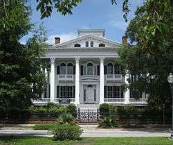 Wilmington Historic and Archeological District |
May 6, 1974 (#74001364) |
Roughly bounded by Wright, S. 7th, and Harnett Sts., and a north-south line 100 yards west of the North East Cape Fear River; also roughly bounded by Harnett, 7th, 3rd, and Howard, Campbell, 9th, 12th, and Princess, Dock, Castle 8th, and 14th, and 9th, Wright, and Greenfield 34°14′06″N 77°57′03″W |
Wilmington | Second set of boundaries represents a boundary increase of May 1, 2003, the Wilmington Historic District |
| 27 | Wilmington National Cemetery | .JPG) Wilmington National Cemetery |
January 31, 1997 (#97000021) |
2011 Market St. 34°14′16″N 77°55′33″W |
Wilmington |
See also
| Wikimedia Commons has media related to National Register of Historic Places in New Hanover County, North Carolina. |
References
- The latitude and longitude information provided in this table was derived originally from the National Register Information System, which has been found to be fairly accurate for about 99% of listings. Some locations in this table may have been corrected to current GPS standards.
- "National Register of Historic Places: Weekly List Actions". National Park Service, United States Department of the Interior. Retrieved on June 19, 2020.
- Numbers represent an ordering by significant words. Various colorings, defined here, differentiate National Historic Landmarks and historic districts from other NRHP buildings, structures, sites or objects.
- "National Register Information System". National Register of Historic Places. National Park Service. April 24, 2008.
- The eight-digit number below each date is the number assigned to each location in the National Register Information System database, which can be viewed by clicking the number.
- http://federal-point-history.org/history-shorts/newton-homesite-and-cemetery/

| Topics | |
|---|---|
| Lists by state |
|
| Lists by insular areas | |
| Lists by associated state | |
| Other areas | |
| Related | |
| |
Municipalities and communities of New Hanover County, North Carolina, United States | ||
|---|---|---|
| City | | |
| Towns | ||
| CDPs | ||
| Unincorporated communities | ||
This article is issued from Wikipedia. The text is licensed under Creative Commons - Attribution - Sharealike. Additional terms may apply for the media files.