National Register of Historic Places listings in Henderson County, North Carolina
This list includes properties and districts listed on the National Register of Historic Places in Henderson County, North Carolina. Click the "Map of all coordinates" link to the right to view an online map of all properties and districts with latitude and longitude coordinates in the table below.[1]

Current listings
- This National Park Service list is complete through NPS recent listings posted June 19, 2020.[2]
| [3] | Name on the Register[4] | Image | Date listed[5] | Location | City or town | Description |
|---|---|---|---|---|---|---|
| 1 | Aloah Hotel |  Aloah Hotel |
February 24, 1989 (#89000036) |
201 3rd Ave., W. 35°18′57″N 82°27′41″W |
Hendersonville | |
| 2 | Berkeley Mills Ballpark | 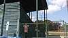 Berkeley Mills Ballpark |
September 19, 2016 (#16000646) |
69 Balfour Rd. 35°20′58″N 82°28′13″W |
Hendersonville | |
| 3 | Brookland | August 19, 1982 (#82003467) |
North of Flat Rock on SR 1863 35°18′10″N 82°26′57″W |
Flat Rock | ||
| 4 | Bryn Avon | April 9, 1999 (#99000437) |
Junction of River Rd. and Mallett Rd. 35°17′48″N 82°34′14″W |
Etowah | ||
| 5 | Camp Arrowhead | December 16, 2005 (#05001415) |
Cabin Creek Rd., 1 mile (1.6 km) west of junction with Green River Rd. 35°12′47″N 82°28′34″W |
Tuxedo | ||
| 6 | The Cedars | 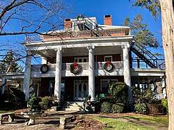 The Cedars |
February 24, 1989 (#89000033) |
219 7th Ave., W. 35°19′10″N 82°27′47″W |
Hendersonville | |
| 7 | Chewning House |  Chewning House |
February 24, 1989 (#89000034) |
755 N. Main St. 35°19′14″N 82°27′41″W |
Hendersonville | |
| 8 | Clarke-Hobbs-Davidson House |  Clarke-Hobbs-Davidson House |
February 24, 1989 (#89000031) |
229 5th Ave., W. 35°19′04″N 82°27′44″W |
Hendersonville | |
| 9 | Cold Spring Park Historic District | January 8, 2009 (#08001291) |
Bounded roughly by N. Main St. on the north, Maple St. on the east, 9th Ave., E., on the south, and Locust St. on the west 35°19′29″N 82°27′39″W |
Hendersonville | ||
| 10 | Mary Mills Coxe House |  Mary Mills Coxe House |
August 26, 1994 (#94001052) |
1210 Greenville Hwy. 35°17′50″N 82°27′05″W |
Hendersonville | |
| 11 | Druid Hills Historic District | August 16, 2000 (#00000989) |
Roughly bounded by Meadowbrook Terrace, U.S. Route 25, Ashwood Rd., and Ridgewood Ave. 35°19′49″N 82°28′16″W |
Hendersonville | ||
| 12 | Flat Rock Historic District | Flat Rock Historic District |
October 15, 1973 (#73001352) |
West of East Flat Rock; also roughly bounded by Rutledge, Dunroy, and N. Highland Lake Drs. and Kanuga, Little River, and W. Blue Ridge Rds. 35°16′18″N 82°27′41″W |
Flat Rock | Second set of addresses represents a boundary adjustment February 27, 2015 |
| 13 | Grey Hosiery Mill |  Grey Hosiery Mill |
October 6, 2000 (#00001189) |
301 Fourth Ave. E 35°19′03″N 82°27′29″W |
Hendersonville | |
| 14 | Henderson County Courthouse |  Henderson County Courthouse |
May 10, 1979 (#79001723) |
1st and Main Sts. 35°18′52″N 82°27′37″W |
Hendersonville | |
| 15 | Hyman Heights-Mount Royal Historic District |  Hyman Heights-Mount Royal Historic District |
February 16, 2001 (#01000124) |
Roughly bounded by Ridgecrest Pl., Highland Ave., Hyman Ave., Patton St., N. Main St., and Oakland St. 35°19′38″N 82°27′53″W |
Hendersonville | |
| 16 | Kanuga Lake Historic District | August 31, 1995 (#95001056) |
Roughly, area surrounding Kanuga Lake 35°15′43″N 82°31′11″W |
Hendersonville | ||
| 17 | Otto King House | May 1, 2017 (#100000940) |
529 Pace Rd. 35°21′09″N 82°23′25″W |
Hendersonville | ||
| 18 | King-Waldrop House |  King-Waldrop House |
June 28, 1989 (#89000030) |
103 S. Washington St. 35°18′53″N 82°27′45″W |
Hendersonville | |
| 19 | Lenox Park Historic District | December 31, 2002 (#02001661) |
Roughly bounded by Allen, Spring, and S. Whitted Sts., and Southern RR. 35°18′36″N 82°28′06″W |
Hendersonville | ||
| 20 | Main Street Historic District |  Main Street Historic District |
March 30, 1989 (#89000028) |
Main St. between 6th and 1st Aves., E.; also roughly N. Main St., 2nd Ave., W., W. Allen St., N. Washington, and 1st Ave., E. 35°18′59″N 82°27′37″W |
Hendersonville | Second set of boundaries represents a boundary increase of December 20, 2006 |
| 21 | The Meadows | 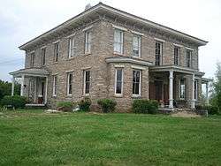 The Meadows |
January 11, 1980 (#80002847) |
North of Fletcher on SR 1547 35°26′11″N 82°29′41″W |
Fletcher | Boundary decrease approved January 10, 2019 |
| 22 | Mills River Chapel | 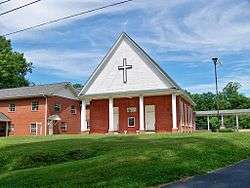 Mills River Chapel |
December 2, 1988 (#88002660) |
SR 1328, 0.7 miles (1.1 km) north of junction with NC 280 35°23′04″N 82°34′39″W |
Mills River | |
| 23 | Arthur W. Moore House | January 4, 2001 (#00001613) |
299 Sunset Dr. 35°20′29″N 82°31′39″W |
Horse Shoe | ||
| 24 | Moss-Johnson Farm | February 10, 1987 (#87000021) |
3346 Haywood Rd. 35°21′34″N 82°30′32″W |
Hendersonville | ||
| 25 | Oakdale Cemetery |  Oakdale Cemetery |
February 5, 2014 (#13001158) |
Northern and southern sides of 6th Ave., W., west of Valley St. 35°19′11″N 82°28′27″W |
Hendersonville | |
| 26 | Reese House |  Reese House |
June 2, 1995 (#95000676) |
202 S. Washington St. 35°18′46″N 82°27′44″W |
Hendersonville | |
| 27 | Clough H. Rice House | December 27, 2011 (#11000974) |
219 Stoney Mountain Rd. 35°20′19″N 82°28′35″W |
Hendersonville | ||
| 28 | Rugby Grange | 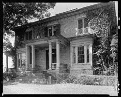 Rugby Grange |
May 5, 1987 (#86003748) |
Address Restricted 35°25′15″N 82°31′15″W |
Fletcher | |
| 29 | Carl Sandburg Home National Historic Site |  Carl Sandburg Home National Historic Site |
October 17, 1968 (#68000013) |
West of Flat Rock 35°16′04″N 82°27′06″W |
Flat Rock | |
| 30 | Seventh Avenue Depot District | 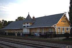 Seventh Avenue Depot District |
March 30, 1989 (#89000029) |
Seventh Ave. between Grove and Ash 35°19′18″N 82°27′27″W |
Hendersonville | |
| 31 | Dillard B. and Georgia Sewell House | April 15, 2015 (#15000164) |
64 Clipper Ln. 35°15′36″N 82°36′15″W |
Penrose | Extends into Transylvania County | |
| 32 | Singletary-Reese-Robinson House | September 16, 2010 (#10000754) |
211 Robinson Ln. 35°18′38″N 82°29′57″W |
Laurel Park | ||
| 33 | Smith-Williams-Durham Boarding House |  Smith-Williams-Durham Boarding House |
February 24, 1989 (#89000032) |
247 5th Ave., W. 35°19′03″N 82°27′46″W |
Hendersonville | |
| 34 | Erle Stillwell House | November 20, 2001 (#01000125) |
1300 Pinecrest Dr. 35°19′05″N 82°28′43″W |
Hendersonville | ||
| 35 | Erle Stillwell House II | September 6, 2002 (#02000933) |
541 Blythe St. 35°19′03″N 82°28′41″W |
Hendersonville | ||
| 36 | The Waverly | 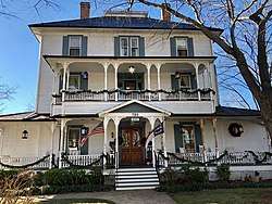 The Waverly |
February 24, 1989 (#89000035) |
783 N. Main St. 35°19′15″N 82°27′42″W |
Hendersonville | |
| 37 | West Side Historic District | 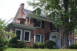 West Side Historic District |
December 31, 2001 (#01001424) |
Roughly bounded by 5th Ave., W., Washington St., 3rd Ave., W., and Blythe St. 35°18′56″N 82°28′12″W |
Hendersonville |
See also
| Wikimedia Commons has media related to National Register of Historic Places in Henderson County, North Carolina. |
References
- The latitude and longitude information provided in this table was derived originally from the National Register Information System, which has been found to be fairly accurate for about 99% of listings. Some locations in this table may have been corrected to current GPS standards.
- "National Register of Historic Places: Weekly List Actions". National Park Service, United States Department of the Interior. Retrieved on June 19, 2020.
- Numbers represent an ordering by significant words. Various colorings, defined here, differentiate National Historic Landmarks and historic districts from other NRHP buildings, structures, sites or objects.
- "National Register Information System". National Register of Historic Places. National Park Service. April 24, 2008.
- The eight-digit number below each date is the number assigned to each location in the National Register Information System database, which can be viewed by clicking the number.

| Topics | |
|---|---|
| Lists by state |
|
| Lists by insular areas | |
| Lists by associated state | |
| Other areas | |
| Related | |
| |
Municipalities and communities of Henderson County, North Carolina, United States | ||
|---|---|---|
| Cities | | |
| Towns | ||
| Village | ||
| CDPs | ||
| Unincorporated communities | ||
| Footnotes | ‡This populated place also has portions in an adjacent county or counties | |
This article is issued from Wikipedia. The text is licensed under Creative Commons - Attribution - Sharealike. Additional terms may apply for the media files.