National Register of Historic Places listings in Alleghany County, North Carolina
This list includes properties and districts listed on the National Register of Historic Places in Alleghany County, North Carolina. Click the "Map of all coordinates" link to the right to view a Google map of all properties and districts with latitude and longitude coordinates in the table below.[1]
- This National Park Service list is complete through NPS recent listings posted June 19, 2020.[2]
Current listings
| [3] | Name on the Register | Image | Date listed[4] | Location | City or town | Description |
|---|---|---|---|---|---|---|
| 1 | Alleghany County Courthouse | 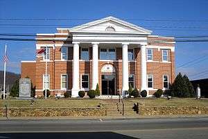 Alleghany County Courthouse |
May 10, 1979 (#79001657) |
Main and Whitehead Sts. 36°30′21″N 81°07′15″W |
Sparta | |
| 2 | Brinegar Cabin |  Brinegar Cabin |
January 20, 1972 (#72000922) |
At miles 238.5, Blue Ridge Pkwy. 36°25′06″N 81°08′44″W |
Whitehead | |
| 3 | Elbert Crouse Farmstead | July 29, 1982 (#82003423) |
S of Whitehead on Blue Ridge Parkway 36°25′50″N 81°08′56″W |
Whitehead | ||
| 4 | Robert L. Doughton House | August 13, 1979 (#79001656) |
NC 18 36°24′38″N 81°15′55″W |
Laurel Springs | ||
| 5 | J.C. Gambill Site | April 3, 1978 (#78001927) |
Address Restricted |
New Haven | ||
| 6 | Bays Hash Site | April 19, 1978 (#78003078) |
Address Restricted |
Amelia | ||
| 7 | Jarvis House | October 16, 1991 (#91001506) |
N end NC 1439, N of jct. with NC 18 36°33′34″N 81°00′43″W |
Sparta | ||
| 8 | Rock House | August 11, 2004 (#04000827) |
7 Chestnut Ln. 36°24′47″N 80°57′46″W |
Roaring Gap | ||
| 9 | William T. Vogler Cottage | September 30, 1991 (#91001492) |
NC 1478 E side, approx. 1.3 miles NE of US 21 36°24′09″N 80°58′05″W |
Roaring Gap | Destroyed[5] | |
| 10 | William Weaver House |  William Weaver House |
November 7, 1976 (#76001297) |
SW of Piney Creek on SR 1302 36°30′13″N 81°19′29″W |
Piney Creek |
See also
| Wikimedia Commons has media related to National Register of Historic Places in Alleghany County, North Carolina. |
References
- The latitude and longitude information provided in this table was derived originally from the National Register Information System, which has been found to be fairly accurate for about 99% of listings. Some locations in this table may have been corrected to current GPS standards.
- "National Register of Historic Places: Weekly List Actions". National Park Service, United States Department of the Interior. Retrieved on June 19, 2020.
- Numbers represent an ordering by significant words. Various colorings, defined here, differentiate National Historic Landmarks and historic districts from other NRHP buildings, structures, sites or objects.
- The eight-digit number below each date is the number assigned to each location in the National Register Information System database, which can be viewed by clicking the number.
- "North Carolina Listings in the National Register of Historic Places by County". North Carolina State Historic Preservation Office. 22 October 2008. Archived from the original on 30 November 2012. Retrieved 14 July 2009.

| Topics | |
|---|---|
| Lists by state |
|
| Lists by insular areas | |
| Lists by associated state | |
| Other areas | |
| Related | |
| |
Municipalities and communities of Alleghany County, North Carolina, United States | ||
|---|---|---|
| Town | | |
| Townships | ||
| Unincorporated communities | ||
This article is issued from Wikipedia. The text is licensed under Creative Commons - Attribution - Sharealike. Additional terms may apply for the media files.