National Register of Historic Places listings in Rockingham County, North Carolina
This list includes properties and districts listed on the National Register of Historic Places in Rockingham County, North Carolina. Click the "Map of all coordinates" link to the right to view an online map of all properties and districts with latitude and longitude coordinates in the table below.[1]
Current listings
- This National Park Service list is complete through NPS recent listings posted June 19, 2020.[2]
| [3] | Name on the Register[4] | Image | Date listed[5] | Location | City or town | Description |
|---|---|---|---|---|---|---|
| 1 | Academy Street Historic District |  Academy Street Historic District |
July 15, 1982 (#82003502) |
Academy St. 36°23′07″N 79°57′39″W |
Madison | |
| 2 | Boone Road Historic District | August 31, 1987 (#87001455) |
Roughly 400 and 500 blocks of Boone Rd., 400 blk. of Chestnut and 500 blk. Glovenia Sts., and 200 blk. of Highland Dr. 36°29′48″N 79°45′40″W |
Eden | ||
| 3 | The Boxwoods |  The Boxwoods |
May 28, 1980 (#80002898) |
Penn Lane 36°22′55″N 79°57′46″W |
Madison | |
| 4 | Bullard-Ray House | June 11, 1982 (#82003501) |
650 Washington St. 36°29′25″N 79°45′51″W |
Eden | ||
| 5 | Cascade Plantation | October 14, 1975 (#75001288) |
NE of Eden off NC 770 36°31′22″N 79°39′29″W |
Eden | ||
| 6 | Central Leaksville Historic District | December 9, 1986 (#86003376) |
Roughly bounded by Lindsay, Monroe, Jay, Washington, & Kemp Sts. 36°29′31″N 79°46′05″W |
Eden | ||
| 7 | Chinqua-Penn Plantation | 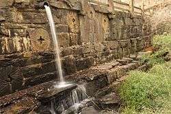 Chinqua-Penn Plantation |
April 8, 1993 (#93000235) |
NC 1998 N side, 0.2 miles W of jct. with NC 1987 36°23′04″N 79°42′00″W |
Reidsville | |
| 8 | Cross Rock Rapid Sluice | March 19, 1984 (#84002459) |
Address Restricted |
Madison | ||
| 9 | Dead Timber Ford Sluices | June 29, 1984 (#84002455) |
Address Restricted |
Wentworth | ||
| 10 | Dempsey-Reynolds-Taylor House | September 8, 1983 (#83001910) |
610 Henry St. 36°29′29″N 79°45′57″W |
Eden | ||
| 11 | Eagle Falls Sluice | March 19, 1984 (#84002462) |
Address Restricted |
Wentworth | ||
| 12 | Fewell-Reynolds House | July 16, 1979 (#79003349) |
Address Restricted |
Madison | ||
| 13 | First Baptist Church | March 22, 1989 (#89000178) |
538 Greenwood St. 36°29′43″N 79°45′50″W |
Eden | ||
| 14 | First Baptist Church | December 11, 1986 (#86003386) |
401 S. Scales St. 36°21′26″N 79°39′52″W |
Reidsville | ||
| 15 | Former Reidsville High School |  Former Reidsville High School |
January 21, 1994 (#93001540) |
116 N. Franklin St. 36°21′46″N 79°40′14″W |
Reidsville | |
| 16 | Gravel Shoals Sluice | March 19, 1984 (#84002458) |
Address Restricted |
Madison | ||
| 17 | High Rock Farm | April 26, 1974 (#74001373) |
SE of Reidsville on SR 2619 36°15′36″N 79°34′00″W |
Williamsburg | ||
| 18 | Jacob's Creek Landing | March 19, 1984 (#84002522) |
Address Restricted |
Madison | ||
| 19 | Jennings-Baker House | March 12, 1987 (#86003387) |
608 Vance St. 36°21′19″N 79°40′42″W |
Reidsville | ||
| 20 | Dr. Franklin King House-Idlewild | September 19, 1985 (#85002415) |
700 blk. of Bridge St. 36°29′26″N 79°45′40″W |
Eden | ||
| 21 | Leaksville Commercial Historic District | 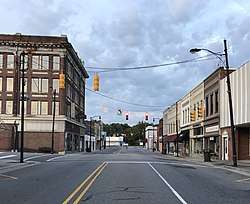 Leaksville Commercial Historic District |
October 23, 1987 (#87001422) |
622-656 Washington & 634 Monroe Sts. 36°29′25″N 79°45′51″W |
Eden | |
| 22 | Leaksville-Spray Institute | March 9, 1989 (#89000179) |
609 College St. 36°29′35″N 79°45′34″W |
Eden | ||
| 23 | Lower Sauratown Plantation | October 11, 1984 (#84000071) |
Address Restricted |
Eden | ||
| 24 | Mayo River Sluice | March 19, 1984 (#84002466) |
Address Restricted |
Madison | ||
| 25 | Mayodan Historic District |  Mayodan Historic District |
August 15, 2016 (#16000222) |
Roughly bounded by West Adams St., North and South Second Ave., and North and South Third Ave. 36°24′43″N 79°58′00″W |
Mayodan | |
| 26 | Reuben Wallace McCollum House | May 1, 2003 (#03000341) |
2203 S. Scales St. 36°18′52″N 79°40′13″W |
Reidsville | ||
| 27 | Mt. Sinai Baptist Church | June 25, 1987 (#87000914) |
512 Henry St. 36°29′38″N 79°46′07″W |
Eden | ||
| 28 | North Washington Avenue Workers' House | December 11, 1986 (#86003388) |
Eastern side of the 300 block of N. Washington Ave. 36°21′55″N 79°40′17″W |
Reidsville | ||
| 29 | Penn House |  Penn House |
November 25, 1983 (#83003992) |
324 Maple Ave. 36°21′27″N 79°40′09″W |
Reidsville | |
| 30 | Gov. David S. Reid House |  Gov. David S. Reid House |
April 26, 1974 (#74001374) |
219 SE Market St. 36°21′36″N 79°39′46″W |
Reidsville | |
| 31 | Reidsville Historic District | March 12, 1987 (#86003391) |
Roughly bounded by W. Morehead, Southern Railway tracks, Lawson Ave., Main, Piedmontg, Vance and Lindsey Sts. 36°21′23″N 79°40′00″W |
Reidsville | ||
| 32 | Richardson Houses Historic District | December 11, 1986 (#86003390) |
NW side of Richardson Dr. between Coach Rd. and Woodland Dr. 36°20′31″N 79°40′58″W |
Reidsville | ||
| 33 | Roberson's Fish Trap Shoal Sluice | March 19, 1984 (#84002468) |
Address Restricted |
Madison | ||
| 34 | Rockingham County Courthouse | 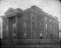 Rockingham County Courthouse |
May 10, 1979 (#79001748) |
Highway 65 36°23′52″N 79°46′16″W |
Wentworth | |
| 35 | Alfred Moore Scales Law Office |  Alfred Moore Scales Law Office |
April 29, 1982 (#82003503) |
307 Carter St. 36°23′23″N 79°57′52″W |
Madison | |
| 36 | Site 31RK1 | May 24, 1984 (#84002474) |
Southern side of the Dan River, southeast of Eden[6] 36°29′23″N 79°42′39″W |
Eden | ||
| 37 | Slink Shoal Sluice and Wing Dams | March 19, 1984 (#84002475) |
Address Restricted |
Madison | ||
| 38 | Spray Industrial Historic District |  Spray Industrial Historic District |
December 9, 1986 (#86003371) |
Roughly bounded by Warehouse, Rhode Island, River Dr., Washburn Rd., the Smith River, E. Early Ave., and Church 36°30′39″N 79°45′22″W |
Eden | |
| 39 | St. Luke's Episcopal Church | March 17, 1989 (#89000177) |
604 Morgan Rd. 36°31′01″N 79°45′39″W |
Eden | ||
| 40 | Tanyard Shoal Sluice | March 19, 1984 (#84002478) |
Address Restricted |
Eden | ||
| 41 | Three Ledges Shoal Sluice | March 19, 1984 (#84002481) |
Address Restricted |
Eden | ||
| 42 | Troublesome Creek Ironworks | September 29, 1972 (#72000989) |
Address Restricted |
Monroeton | ||
| 43 | Washington Mills-Mayodan Plant |  Washington Mills-Mayodan Plant |
April 20, 2005 (#05000319) |
7801 NC 35 36°24′32″N 79°57′57″W |
Mayodan | |
| 44 | Wentworth Methodist Episcopal Church and Cemetery | March 13, 1986 (#86000391) |
NC 65 W of SR 2124 36°24′03″N 79°46′40″W |
Wentworth | ||
| 45 | Wide Mouth Shoal Sluice | March 19, 1984 (#84002484) |
Address Restricted |
Eden | ||
| 46 | Wright Tavern | Wright Tavern |
September 15, 1970 (#70000467) |
NC 65 36°23′54″N 79°46′13″W |
Wentworth |
See also
| Wikimedia Commons has media related to National Register of Historic Places in Rockingham County, North Carolina. |
References
- The latitude and longitude information provided in this table was derived originally from the National Register Information System, which has been found to be fairly accurate for about 99% of listings. Some locations in this table may have been corrected to current GPS standards.
- "National Register of Historic Places: Weekly List Actions". National Park Service, United States Department of the Interior. Retrieved on June 19, 2020.
- Numbers represent an ordering by significant words. Various colorings, defined here, differentiate National Historic Landmarks and historic districts from other NRHP buildings, structures, sites or objects.
- "National Register Information System". National Register of Historic Places. National Park Service. April 24, 2008.
- The eight-digit number below each date is the number assigned to each location in the National Register Information System database, which can be viewed by clicking the number.
- Master Site Record, Research Laboratories of Archaeology, University of North Carolina at Chapel Hill, n.d. Accessed 2014-06-23.

| Topics | |
|---|---|
| Lists by state |
|
| Lists by insular areas | |
| Lists by associated state | |
| Other areas | |
| Related | |
| |
Municipalities and communities of Rockingham County, North Carolina, United States | ||
|---|---|---|
| Cities | | |
| Towns | ||
| Townships | ||
| CDP | ||
| Unincorporated communities | ||
This article is issued from Wikipedia. The text is licensed under Creative Commons - Attribution - Sharealike. Additional terms may apply for the media files.