National Register of Historic Places listings in Jackson County, North Carolina
This list includes properties and districts listed on the National Register of Historic Places in Jackson County, North Carolina. Click the "Map of all coordinates" link to the right to view a Google map of all properties and districts with latitude and longitude coordinates in the table below.[1]
Current listings
- This National Park Service list is complete through NPS recent listings posted June 19, 2020.[2]
| [3] | Name on the Register | Image | Date listed[4] | Location | City or town | Description |
|---|---|---|---|---|---|---|
| 1 | E. M. Backus Lodge |  E. M. Backus Lodge |
June 9, 1988 (#88000689) |
Cold Mountain Gap Rd. 35°09′38″N 82°59′51″W |
Lake Toxaway | Extends into Transylvania County |
| 2 | Balsam Mountain Inn | Balsam Mountain Inn |
July 15, 1982 (#82003475) |
SR 1700 and SR 1701 35°25′31″N 83°05′14″W |
Balsam | |
| 3 | Camp Merrie-Woode | 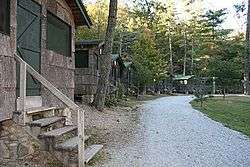 Camp Merrie-Woode |
June 2, 1995 (#95000674) |
US 64 N side, 1.6 miles (2.6 km) N of jct. with NC 1120, at end of a one-mile-long (1.6 km) dirt rd. 35°07′59″N 83°02′38″W |
Cashiers | |
| 4 | Church of the Good Shepherd | .jpg) Church of the Good Shepherd |
February 20, 1986 (#86000317) |
NC 107 at SR 1118 35°05′49″N 83°05′07″W |
Cashiers | |
| 5 | Downtown Sylva Historic District |  Downtown Sylva Historic District |
September 3, 2014 (#14000545) |
Roughly bounded by Southern RR., Main, Landis & Jackson Sts. 35°22′25″N 83°13′29″W |
Sylva | |
| 6 | Fairfield Inn | 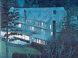 Fairfield Inn |
June 14, 1982 (#82003476) |
U.S. 64 35°07′26″N 83°02′39″W |
Cashiers | Demolished[5] |
| 7 | Lucius Coleman Hall House | .jpg) Lucius Coleman Hall House |
March 9, 1990 (#90000365) |
Off NC 116, 0.1 miles (0.16 km) E of jct. with SR 1367 35°20′40″N 83°13′43″W |
Webster | |
| 8 | Elisha Calor Hedden House | .jpg) Elisha Calor Hedden House |
December 21, 1989 (#89002133) |
Main St. and Old Webster-Sylva Rd. 35°20′47″N 83°13′08″W |
Webster | |
| 9 | High Hampton Inn Historic District | 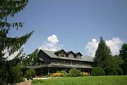 High Hampton Inn Historic District |
September 26, 1991 (#91001468) |
NC 107 E side, 1.5 miles (2.4 km) S of US 64 35°05′56″N 83°04′57″W |
Cashiers | |
| 10 | Dr. D. D. Hooper House | .jpg) Dr. D. D. Hooper House |
April 21, 2000 (#00000395) |
773 W. Main St. 35°22′25″N 83°13′37″W |
Sylva | |
| 11 | Jackson County Courthouse | 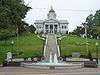 Jackson County Courthouse |
May 10, 1979 (#79001727) |
Main St. 35°22′26″N 83°13′41″W |
Sylva | |
| 12 | Joyner Building | 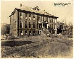 Joyner Building |
December 8, 1978 (#78001961) |
Western Carolina University Campus 35°18′40″N 83°10′40″W |
Cullowhee | Burned[5] |
| 13 | Judaculla Rock |  Judaculla Rock |
March 27, 2013 (#13000116) |
552 Judaculla Rock Rd. 35°18′02″N 83°06′34″W |
Cullowhee | |
| 14 | Elias Brendle Monteith House and Outbuildings | .jpg) Elias Brendle Monteith House and Outbuildings |
August 13, 2008 (#08000778) |
111 Hometown Place Rd. 35°22′22″N 83°14′41″W |
Dillsboro | |
| 15 | Walter E. Moore House | .jpg) Walter E. Moore House |
February 23, 1990 (#90000322) |
Main St. 35°20′44″N 83°13′11″W |
Webster | |
| 16 | Mount Beulah Hotel |  Mount Beulah Hotel |
March 1, 1984 (#84002337) |
US 23 and 441 35°22′11″N 83°15′07″W |
Dillsboro | |
| 17 | Webster Baptist Church | .jpg) Webster Baptist Church |
December 21, 1989 (#89002137) |
NC 116 and SR 1340 35°20′23″N 83°13′36″W |
Webster | |
| 18 | Webster Methodist Church | .jpg) Webster Methodist Church |
December 21, 1989 (#89002130) |
NC 116/Main St. 35°20′38″N 83°13′22″W |
Webster | |
| 19 | Webster Rock School | .jpg) Webster Rock School |
January 4, 1990 (#89002262) |
Main St. 35°20′37″N 83°13′23″W |
Webster | |
| 20 | Mordecai Zachary House | .jpg) Mordecai Zachary House |
December 31, 1998 (#98001575) |
NC 107, 0.2 miles (0.32 km) S of NC 1107 35°05′28″N 83°04′51″W |
Cashiers |
See also
| Wikimedia Commons has media related to National Register of Historic Places in Jackson County, North Carolina. |
References
- The latitude and longitude information provided in this table was derived originally from the National Register Information System, which has been found to be fairly accurate for about 99% of listings. Some locations in this table may have been corrected to current GPS standards.
- "National Register of Historic Places: Weekly List Actions". National Park Service, United States Department of the Interior. Retrieved on June 19, 2020.
- Numbers represent an ordering by significant words. Various colorings, defined here, differentiate National Historic Landmarks and historic districts from other NRHP buildings, structures, sites or objects.
- The eight-digit number below each date is the number assigned to each location in the National Register Information System database, which can be viewed by clicking the number.
- "North Carolina Listings in the National Register of Historic Places by County". North Carolina State Historic Preservation Office. 22 October 2008. Archived from the original on 30 November 2012. Retrieved 14 July 2009.

| Topics | |
|---|---|
| Lists by state |
|
| Lists by insular areas | |
| Lists by associated state | |
| Other areas | |
| Related | |
| |
Municipalities and communities of Jackson County, North Carolina, United States | ||
|---|---|---|
| Towns | | |
| Village | ||
| CDPs | ||
| Unincorporated communities | ||
| Indian reservation | ||
| Footnotes | ‡This populated place also has portions in an adjacent county or counties | |
This article is issued from Wikipedia. The text is licensed under Creative Commons - Attribution - Sharealike. Additional terms may apply for the media files.