National Register of Historic Places listings in Polk County, North Carolina
This list includes properties and districts listed on the National Register of Historic Places in Polk County, North Carolina. Click the "Map of all coordinates" link to the right to view a Google map of all properties and districts with latitude and longitude coordinates in the table below.[1]

Current listings
- This National Park Service list is complete through NPS recent listings posted June 19, 2020.[2]
| [3] | Name on the Register | Image | Date listed[4] | Location | City or town | Description |
|---|---|---|---|---|---|---|
| 1 | Bank of Tryon Building | 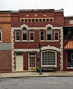 Bank of Tryon Building |
January 17, 2008 (#07001408) |
16 N. Trade St. 35°12′33″N 82°14′22″W |
Tryon | |
| 2 | Blackberry Hill | November 21, 1974 (#74001372) |
East of Tryon on SR 1516 35°12′28″N 82°12′04″W |
Tryon | ||
| 3 | Blockhouse Site |  Blockhouse Site |
October 15, 1970 (#70000466) |
East of U.S. Route 176 35°11′47″N 82°13′04″W |
Tryon | |
| 4 | Charlton Leland |  Charlton Leland |
April 5, 2006 (#06000225) |
229 Greenville St. 35°14′00″N 82°21′05″W |
Saluda | |
| 5 | Church of the Transfiguration | Church of the Transfiguration |
November 12, 1982 (#82001301) |
Henderson and Charles Sts. 35°14′12″N 82°20′48″W |
Saluda | |
| 6 | Downtown Tryon Historic District |  Downtown Tryon Historic District |
December 15, 2015 (#15000900) |
Both sides of N. & S. Trade Sts., RR. right-of-way between 98 N. & 55 S. Trade Sts. 35°12′32″N 82°14′19″W |
Tryon | |
| 7 | Friendly Hills | June 26, 1998 (#98000731) |
140 Country Club Rd. 35°13′13″N 82°15′01″W |
Tryon | ||
| 8 | Green River Plantation | 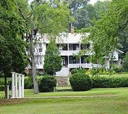 Green River Plantation |
March 28, 1974 (#74001370) |
East of Columbus off SR 1005 35°17′12″N 82°01′06″W |
Columbus | |
| 9 | J. G. Hughes House |  J. G. Hughes House |
May 5, 1989 (#89000347) |
N. Peak St. 35°15′14″N 82°11′59″W |
Columbus | |
| 10 | John Hiram Johnson House | February 7, 1994 (#94000005) |
Address Restricted |
Saluda | ||
| 11 | Rev. Joshua D. Jones House |  Rev. Joshua D. Jones House |
September 26, 1991 (#91001476) |
NC 1526 south side, 0.4 miles (0.64 km) from NC 108 35°17′24″N 82°09′51″W |
Mill Spring | |
| 12 | Lynncote |  Lynncote |
August 30, 2010 (#10000604) |
3318 Lynn Rd. 35°12′51″N 82°14′29″W |
Tryon | |
| 13 | Mill Farm Inn | 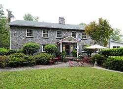 Mill Farm Inn |
January 22, 2009 (#08001366) |
701 Harmon Field Rd. 35°13′24″N 82°14′52″W |
Tryon | |
| 14 | Mills-Screven Plantation |  Mills-Screven Plantation |
February 17, 1983 (#83001904) |
Northeast of Tryon on SR 1509 35°13′04″N 82°13′33″W |
Tryon | |
| 15 | Pine Crest Inn |  Pine Crest Inn |
April 15, 1982 (#82003500) |
Pine Crest Lane 35°12′31″N 82°14′02″W |
Tryon | |
| 16 | Polk County Courthouse | 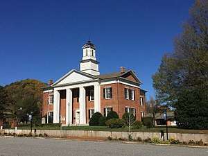 Polk County Courthouse |
November 8, 1974 (#74001371) |
Courthouse St. 35°15′05″N 82°11′54″W |
Columbus | |
| 17 | Railway Clerks' Mountain House | 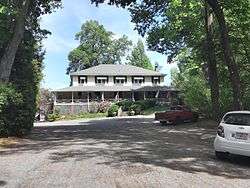 Railway Clerks' Mountain House |
July 28, 2000 (#00000842) |
100 Orchard Inn Lane (U.S. Route 176, 0.6 miles (0.97 km) southeast of the junction with Ozone Rd.) 35°13′50″N 82°20′10″W |
Saluda | |
| 18 | Ryder Hall |  Ryder Hall |
September 15, 2005 (#05001033) |
305 Seminary St. 35°14′14″N 82°20′35″W |
Saluda | |
| 19 | Saluda Main Street Historic District | 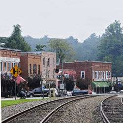 Saluda Main Street Historic District |
May 29, 1996 (#96000569) |
Main St. from Cullipher St. to Carolina St. 35°14′10″N 82°20′54″W |
Saluda | |
| 20 | Seven Hearths |  Seven Hearths |
March 26, 1976 (#76001333) |
North of Tryon at junction of U.S. Route 176 and Harmon Field Rd. 35°13′20″N 82°15′04″W |
Tryon | |
| 21 | Stone Hedge | April 21, 2015 (#15000166) |
222 Stone Hedge Ln. 35°14′41″N 82°14′52″W |
Tryon | ||
| 22 | Sunnydale |  Sunnydale |
December 7, 2011 (#11000890) |
334 S. Trade St. 35°12′15″N 82°14′16″W |
Tryon | |
| 23 | Tryon Country Club |  Tryon Country Club |
February 5, 2013 (#12001262) |
393 Country Club Rd. 35°13′07″N 82°15′16″W |
Tryon |
See also
| Wikimedia Commons has media related to National Register of Historic Places in Polk County, North Carolina. |
References
- The latitude and longitude information provided in this table was derived originally from the National Register Information System, which has been found to be fairly accurate for about 99% of listings. Some locations in this table may have been corrected to current GPS standards.
- "National Register of Historic Places: Weekly List Actions". National Park Service, United States Department of the Interior. Retrieved on June 19, 2020.
- Numbers represent an ordering by significant words. Various colorings, defined here, differentiate National Historic Landmarks and historic districts from other NRHP buildings, structures, sites or objects.
- The eight-digit number below each date is the number assigned to each location in the National Register Information System database, which can be viewed by clicking the number.

| Topics | |
|---|---|
| Lists by state |
|
| Lists by insular areas | |
| Lists by associated state | |
| Other areas | |
| Related | |
| |
Municipalities and communities of Polk County, North Carolina, United States | ||
|---|---|---|
| City | | |
| Towns | ||
| Unincorporated communities | ||
| Footnotes | ‡This populated place also has portions in an adjacent county or counties | |
This article is issued from Wikipedia. The text is licensed under Creative Commons - Attribution - Sharealike. Additional terms may apply for the media files.