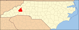
National Register of Historic Places listings in McDowell County, North Carolina
This list includes properties and districts listed on the National Register of Historic Places in McDowell County, North Carolina. Click the "Map of all coordinates" link to the right to view a Google map of all properties and districts with latitude and longitude coordinates in the table below.[1]
Current listings
- This National Park Service list is complete through NPS recent listings posted June 19, 2020.[2]
| [3] | Name on the Register | Image | Date listed[4] | Location | City or town | Description |
|---|---|---|---|---|---|---|
| 1 | Welsford Parker Artz House |  Welsford Parker Artz House |
August 23, 1990 (#90001311) |
205 Maple St. 35°37′54″N 82°10′45″W |
Old Fort | |
| 2 | Henry Seawell Brown and Mary Jane English Farmstead | September 3, 2009 (#09000685) |
15956 U.S. Route 221 North 35°51′57″N 81°57′13″W |
Ashford | ||
| 3 | Carson House | 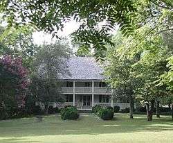 Carson House |
September 15, 1970 (#70000843) |
West of Marion on U.S. Route 70 35°41′27″N 82°03′25″W |
Marion | |
| 4 | Carson-Young House | July 28, 2011 (#11000483) |
842 Major Conley Rd. 35°42′25″N 82°03′16″W |
Marion | ||
| 5 | Depot Historic District | 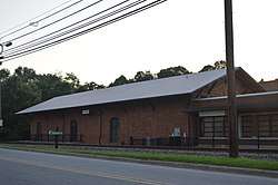 Depot Historic District |
March 28, 1991 (#91000293) |
Southeastern end of Depot St., bounded on the south by the Southern railroad tracks, and 111 Railroad St., south of the tracks 35°40′52″N 82°00′38″W |
Marion | |
| 6 | First Presbyterian Church | 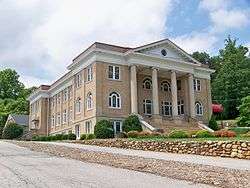 First Presbyterian Church |
March 28, 1991 (#91000291) |
12 W. Fort St. 35°41′03″N 82°00′46″W |
Marion | |
| 7 | Albertus Ledbetter House | January 4, 2001 (#00001616) |
125 Haynes Rd. 35°32′08″N 82°06′17″W |
Montford Cove | ||
| 8 | Lone Beech | June 2, 1995 (#95000639) |
206 Hillcrest Dr. 35°41′07″N 82°00′47″W |
Marion | ||
| 9 | Main Street Historic District |  Main Street Historic District |
March 28, 1991 (#91000292) |
Roughly bounded by U.S. Route 70 and Garden, State, and Logan Sts. 35°41′04″N 82°00′35″W |
Marion | |
| 10 | McDowell County Courthouse | 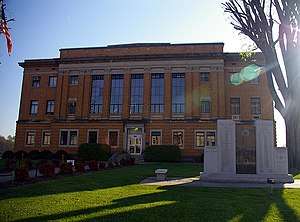 McDowell County Courthouse |
May 10, 1979 (#79003131) |
Main and E. Court Sts. 35°41′02″N 82°00′32″W |
Marion | |
| 11 | Old Fort Commercial Historic District |  Old Fort Commercial Historic District |
April 29, 2011 (#11000257) |
Roughly bounded by E. Main, Spring, Commerce, and W. Main Sts. 35°37′45″N 82°10′53″W |
Old Fort | |
| 12 | St. John's Episcopal Church |  St. John's Episcopal Church |
March 28, 1991 (#91000290) |
315 S. Main St. 35°40′48″N 82°00′25″W |
Marion | |
| 13 | St. Matthew's Lutheran Church |  St. Matthew's Lutheran Church |
March 28, 1991 (#91000289) |
307 W. Court St. 35°40′57″N 82°00′47″W |
Marion |
See also
| Wikimedia Commons has media related to National Register of Historic Places in McDowell County, North Carolina. |
References
- The latitude and longitude information provided in this table was derived originally from the National Register Information System, which has been found to be fairly accurate for about 99% of listings. Some locations in this table may have been corrected to current GPS standards.
- "National Register of Historic Places: Weekly List Actions". National Park Service, United States Department of the Interior. Retrieved on June 19, 2020.
- Numbers represent an ordering by significant words. Various colorings, defined here, differentiate National Historic Landmarks and historic districts from other NRHP buildings, structures, sites or objects.
- The eight-digit number below each date is the number assigned to each location in the National Register Information System database, which can be viewed by clicking the number.

| Topics | |
|---|---|
| Lists by state |
|
| Lists by insular areas | |
| Lists by associated state | |
| Other areas | |
| Related | |
| |
Municipalities and communities of McDowell County, North Carolina, United States | ||
|---|---|---|
| City | McDowell County map | |
| Town | ||
| CDP | ||
| Unincorporated communities |
| |
| Footnotes | ‡This populated place also has portions in an adjacent county or counties | |
This article is issued from Wikipedia. The text is licensed under Creative Commons - Attribution - Sharealike. Additional terms may apply for the media files.