National Register of Historic Places listings in Vance County, North Carolina
This list includes properties and districts listed on the National Register of Historic Places in Vance County, North Carolina. Click the "Map of all coordinates" link to the right to view an online map of all properties and districts with latitude and longitude coordinates in the table below.[1]
Current listings
- This National Park Service list is complete through NPS recent listings posted June 26, 2020.[2]
| [3] | Name on the Register[4] | Image | Date listed[5] | Location | City or town | Description |
|---|---|---|---|---|---|---|
| 1 | Ashburn Hall | August 16, 1977 (#77001009) |
W of Kittrell on SR 1101 36°12′19″N 78°30′09″W |
Kittrell | ||
| 2 | Ashland | .tif.jpg) Ashland |
March 14, 1973 (#73001371) |
N of Henderson on Satterwhite Point Rd. 36°25′55″N 78°22′09″W |
Henderson | |
| 3 | Barker House | December 1, 2014 (#14000993) |
1785 Barker Rd. 36°22′42″N 78°30′10″W |
Henderson | ||
| 4 | Belvidere | November 12, 1992 (#92001603) |
NC 1329, NE end 36°28′14″N 78°23′05″W |
Williamsboro | ||
| 5 | Burnside Plantation House | 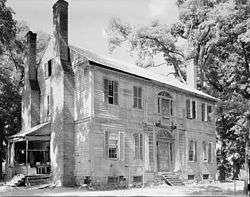 Burnside Plantation House |
April 16, 1971 (#71000621) |
On SR 1335 36°26′02″N 78°27′45″W |
Williamsboro | |
| 6 | Thomas Capehart House |  Thomas Capehart House |
May 6, 1977 (#77001010) |
W of Kittrell on SR 1105 36°13′47″N 78°28′00″W |
Kittrell | |
| 7 | Josiah Crudup House | September 25, 1979 (#79003342) |
S of Kittrell on US 1 36°11′17″N 78°26′59″W |
Kittrell | ||
| 8 | Henderson Central Business Historic District |  Henderson Central Business Historic District |
August 24, 1987 (#87001249) |
Garnett St. from Church to Young Sts. 36°19′34″N 78°24′19″W |
Henderson | |
| 9 | Henderson Fire Station and Municipal Building | 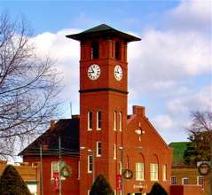 Henderson Fire Station and Municipal Building |
August 10, 1978 (#78001973) |
Garnett and Young Sts. 36°19′40″N 78°24′08″W |
Henderson | |
| 10 | LaGrange | 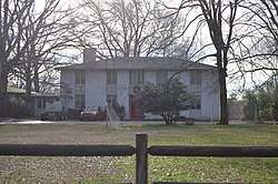 LaGrange |
April 27, 1982 (#82003519) |
South of Townsville off SR 1308 36°24′17″N 78°24′42″W |
Harris Crossroads | |
| 11 | Library and Laboratory Building-Henderson Institute | 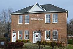 Library and Laboratory Building-Henderson Institute |
November 29, 1995 (#95001399) |
629 W. Rock Spring St. 36°20′18″N 78°24′00″W |
Henderson | |
| 12 | Machpelah | March 27, 2007 (#07000215) |
12079 NC 39, approx. 0.5 mi (1 km). S of Townsville 36°29′11″N 78°25′58″W |
Townsville | ||
| 13 | Mistletoe Villa | 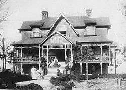 Mistletoe Villa |
August 10, 1978 (#78001974) |
Young Ave. 36°19′14″N 78°24′33″W |
Henderson | |
| 14 | Thomas A. Morgan Farm | December 19, 2019 (#100004798) |
1471, 1473 & 1475 Morgan Rd. 36°28′33″N 78°27′41″W |
Townsville vicinity | ||
| 15 | Maria Parham Hospital |  Maria Parham Hospital |
September 2, 1994 (#94001066) |
406 S. Chestnut St. 36°19′37″N 78°24′30″W |
Henderson | |
| 16 | Pleasant Hill/Hawkins House |  Pleasant Hill/Hawkins House |
March 19, 1979 (#79001758) |
W of Middleburg on SR 1371 36°24′02″N 78°20′34″W |
Middleburg | Home of Philemon Hawkins II built in 1759 |
| 17 | Pool Rock Plantation |  Pool Rock Plantation |
November 29, 1978 (#78001977) |
NE of Williamsboro on SR 1380 36°27′17″N 78°25′04″W |
Williamsboro | |
| 18 | St. James Episcopal Church and Rectory |  St. James Episcopal Church and Rectory |
December 14, 1978 (#78001976) |
Jct. of SR 1551 and SR 1555 36°13′22″N 78°26′25″W |
Kittrell | |
| 19 | St. John's Episcopal Church | St. John's Episcopal Church |
April 16, 1971 (#71000622) |
SR 1329 36°25′46″N 78°26′03″W |
Williamsboro | |
| 20 | Daniel Stone Plank House |  Daniel Stone Plank House |
July 12, 1984 (#84002531) |
Address Restricted |
Henderson | |
| 21 | Vance County Courthouse | .jpg) Vance County Courthouse |
May 10, 1979 (#79001757) |
Young St. 36°19′43″N 78°24′08″W |
Henderson | |
| 22 | West End School |  West End School |
February 2, 2005 (#04001585) |
1000 S. Chestnut St. 36°19′24″N 78°24′48″W |
Henderson | |
| 23 | Zollicoffer's Law Office |  Zollicoffer's Law Office |
June 13, 1978 (#78001975) |
215 N. Garnett St. 36°19′41″N 78°24′06″W |
Henderson |
See also
| Wikimedia Commons has media related to National Register of Historic Places in Vance County, North Carolina. |
References
- The latitude and longitude information provided in this table was derived originally from the National Register Information System, which has been found to be fairly accurate for about 99% of listings. Some locations in this table may have been corrected to current GPS standards.
- "National Register of Historic Places: Weekly List Actions". National Park Service, United States Department of the Interior. Retrieved on June 26, 2020.
- Numbers represent an ordering by significant words. Various colorings, defined here, differentiate National Historic Landmarks and historic districts from other NRHP buildings, structures, sites or objects.
- "National Register Information System". National Register of Historic Places. National Park Service. April 24, 2008.
- The eight-digit number below each date is the number assigned to each location in the National Register Information System database, which can be viewed by clicking the number.

| Topics | |
|---|---|
| Lists by state |
|
| Lists by insular areas | |
| Lists by associated state | |
| Other areas | |
| Related | |
| |
Municipalities and communities of Vance County, North Carolina, United States | ||
|---|---|---|
| City | | |
| Towns | ||
| CDP | ||
| Unincorporated communities |
| |
| Footnotes | ‡This populated place also has portions in an adjacent county or counties | |
This article is issued from Wikipedia. The text is licensed under Creative Commons - Attribution - Sharealike. Additional terms may apply for the media files.