National Register of Historic Places listings in Mecklenburg County, North Carolina
This list includes properties and districts listed on the National Register of Historic Places in Mecklenburg County, North Carolina. Click the "Map of all coordinates" link to the right to view an online map of all properties and districts with latitude and longitude coordinates in the table below.[1]
Current listings
- This National Park Service list is complete through NPS recent listings posted June 19, 2020.[2]
| [3] | Name on the Register[4] | Image | Date listed[5] | Location | City or town | Description |
|---|---|---|---|---|---|---|
| 1 | Addison Apartments |  Addison Apartments |
August 23, 1990 (#90001314) |
831 E. Morehead St. 35°12′50″N 80°50′41″W |
Charlotte | |
| 2 | Hezekiah Alexander House | .jpg) Hezekiah Alexander House |
April 17, 1970 (#70000461) |
3500 Shamrock Dr. 35°13′55″N 80°46′00″W |
Charlotte | |
| 3 | Neal Somers Alexander House | 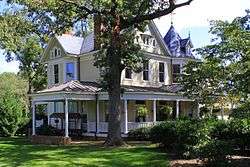 Neal Somers Alexander House |
May 7, 2008 (#08000381) |
5014 N. Sharon Amity Rd. 35°13′38″N 80°44′49″W |
Charlotte | |
| 4 | William T. Alexander House | January 15, 2003 (#02001718) |
Mallard Creek Church Rd., 0.1 miles west of its junction with U.S. Route 29 35°19′23″N 80°44′05″W |
Charlotte | ||
| 5 | Barringer Hotel |  Barringer Hotel |
August 29, 2011 (#11000637) |
426 N. Tryon St. 35°13′48″N 80°50′19″W |
Charlotte | |
| 6 | Beaver Dam Plantation House | 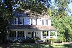 Beaver Dam Plantation House |
March 19, 1979 (#79001735) |
Southeast of Davidson on NC 73 35°28′32″N 80°49′04″W |
Davidson | |
| 7 | Biddle Memorial Hall, Johnson C. Smith University | 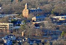 Biddle Memorial Hall, Johnson C. Smith University |
October 14, 1975 (#75001281) |
Beatties Ford Rd. and W. Trade St. 35°14′36″N 80°51′26″W |
Charlotte | |
| 8 | Billingsville School |  Billingsville School |
November 12, 1999 (#99001366) |
3100 Leroy St. 35°11′46″N 80°48′30″W |
Charlotte | |
| 9 | Chairman Blake House |  Chairman Blake House |
August 25, 2004 (#04000905) |
318 Chairman Blake Ln. 35°29′52″N 80°50′54″W |
Davidson | |
| 10 | James A. Blakeney House | June 18, 1998 (#98000706) |
Western side of NC 3629, ½ mile south of the NC 3626 junction 35°02′24″N 80°49′05″W |
Providence | ||
| 11 | Philip Carey Building |  Philip Carey Building |
March 1, 1984 (#84002408) |
301 E. 7th St. 35°13′39″N 80°50′23″W |
Charlotte | |
| 12 | Carolina School Supply Company Building (Former) |  Carolina School Supply Company Building (Former) |
April 12, 2001 (#01000374) |
1023 W. Morehead St. 35°13′41″N 80°51′38″W |
Charlotte | |
| 13 | Carolina Transfer and Storage Company Building, (Former) |  Carolina Transfer and Storage Company Building, (Former) |
November 30, 1999 (#99001447) |
1230 W. Morehead St. 35°13′44″N 80°51′42″W |
Charlotte | |
| 14 | John Price Carr House |  John Price Carr House |
October 22, 1980 (#80002885) |
200-206 N. McDowell St. 35°13′16″N 80°50′00″W |
Charlotte | |
| 15 | Cedar Grove | February 1, 1972 (#72000976) |
3 miles west of Huntersville off U.S. Route 21 35°23′40″N 80°53′55″W |
Huntersville | ||
| 16 | Charlotte Fire Station No. 4 |  Charlotte Fire Station No. 4 |
December 20, 2016 (#16000879) |
420 W. 5th St. 35°13′52″N 80°50′44″W |
Charlotte | |
| 17 | Charlotte Supply Company Building | 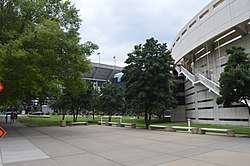 Charlotte Supply Company Building |
March 1, 1984 (#84002348) |
500 S. Mint St. 35°13′35″N 80°51′02″W |
Charlotte | Demolished June 1991[6] |
| 18 | Commercial Building at 500 North Tryon Street |  Commercial Building at 500 North Tryon Street |
November 20, 1992 (#92001615) |
500 N. Tryon St. 35°13′48″N 80°50′18″W |
Charlotte | |
| 19 | Crane Company Building (Former) |  Crane Company Building (Former) |
May 8, 2001 (#01000423) |
1307 W. Morehead St. 35°13′42″N 80°51′50″W |
Charlotte | |
| 20 | Dr. Walter Pharr Craven House |  Dr. Walter Pharr Craven House |
January 31, 1991 (#90002187) |
7648 Mt. Holly-Huntersville Rd. 35°20′47″N 80°53′47″W |
Charlotte | |
| 21 | Croft Historic District |  Croft Historic District |
June 10, 1999 (#99000699) |
Junction of NC 115 and NC 2483 35°20′44″N 80°49′23″W |
Charlotte | |
| 22 | Benjamin W. Davidson House | April 26, 1976 (#76001331) |
West of Huntersville on NC 2138 35°23′45″N 80°52′34″W |
Huntersville | ||
| 23 | Davidson Historic District |  Davidson Historic District |
June 1, 2009 (#09000381) |
Bounded by N. Main and Beaty Sts., Catawba Ave., Mocks and Concord Rds., Pat Stough and Dogwood Lns., Davidson College 35°29′58″N 80°50′55″W |
Davidson | |
| 24 | Dilworth Historic District | _-_exterior_3_cropped.jpg) Dilworth Historic District |
April 9, 1987 (#87000610) |
Roughly bounded by Myrtle, Morehead, Berkeley, Dilworth Rd., W., Charlotte, Park, Tremont, Cleveland and Renssalaer; also the eastern side of the 2000 block of Euclid Ave. and both sides of the 2000 block of Lyndhurst Ave. 35°12′28″N 80°51′00″W |
Charlotte | Second set of boundaries represents a boundary increase of December 7, 2000 |
| 25 | James Buchanan Duke House | .jpg) James Buchanan Duke House |
January 20, 1978 (#78001963) |
400 Hermitage Rd. 35°12′05″N 80°49′39″W |
Charlotte | |
| 26 | East Avenue Tabernacle Associate Reformed Presbyterian Church |  East Avenue Tabernacle Associate Reformed Presbyterian Church |
January 20, 2005 (#04001523) |
927 Elizabeth St. 35°13′10″N 80°50′04″W |
Charlotte | |
| 27 | Elizabeth Historic District |  Elizabeth Historic District |
January 3, 1989 (#88003003) |
Roughly bounded by Central Ave., Seaboard Coast Line Railroad, E. 5th St., Kenmore Ave., Park Dr., and E. Independence 35°12′51″N 80°49′05″W |
Charlotte | |
| 28 | Eumenean Hall, Davidson College | 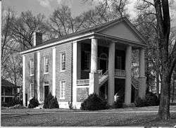 Eumenean Hall, Davidson College |
April 13, 1972 (#72000974) |
Davidson College campus 35°30′00″N 80°50′51″W |
Davidson | |
| 29 | John F. Ewart Farm | February 4, 1991 (#91000023) |
12920 Huntersville-Concord Rd. 35°24′45″N 80°49′26″W |
Huntersville | ||
| 30 | Fire Station No. 2 |  Fire Station No. 2 |
October 22, 1980 (#80002886) |
1212 South Blvd. 35°13′01″N 80°51′06″W |
Charlotte | |
| 31 | First Presbyterian Church |  First Presbyterian Church |
November 12, 1982 (#82001300) |
200 W. Trade St. 35°13′44″N 80°50′38″W |
Charlotte | |
| 32 | Former Charlotte Coca-Cola Bottling Company Plant |  Former Charlotte Coca-Cola Bottling Company Plant |
February 26, 1998 (#98000157) |
1401–1409 W. Morehead St. 35°13′43″N 80°51′52″W |
Charlotte | |
| 33 | Former Nebel Knitting Mill |  Former Nebel Knitting Mill |
September 5, 1991 (#91001376) |
101 W. Worthington Ave. 35°12′41″N 80°51′38″W |
Charlotte | |
| 34 | Former Parks-Cramer Company Complex |  Former Parks-Cramer Company Complex |
March 7, 1994 (#94000146) |
2000 South Boulevard 35°12′35″N 80°51′40″W |
Charlotte | |
| 35 | Former Thrift Mill | _-_Charlotte%2C_NC_-_9-20-2014.jpg) Former Thrift Mill |
August 26, 1994 (#94001049) |
8300 Moore's Chapel Rd. 35°16′37″N 80°56′40″W |
Charlotte | |
| 36 | Former Daniel A. Tompkins Company Machine Shop |  Former Daniel A. Tompkins Company Machine Shop |
May 8, 2001 (#01000422) |
1900 South Boulevard 35°12′39″N 80°51′36″W |
Charlotte | |
| 37 | Frederick Apartments |  Frederick Apartments |
April 5, 2001 (#01000341) |
515 N. Church St. 35°13′54″N 80°50′22″W |
Charlotte | |
| 38 | Thomas and Latitia Gluyas House | July 11, 2001 (#01000725) |
7314 Mount Holly-Huntersville Rd. 35°20′39″N 80°54′03″W |
Huntersville | ||
| 39 | Grace A.M.E. Zion Church | 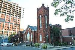 Grace A.M.E. Zion Church |
May 15, 2008 (#08000412) |
219-223 S. Brevard St. 35°13′24″N 80°50′31″W |
Charlotte | |
| 40 | Sidney and Ethel Grier House | August 23, 2006 (#06000724) |
4747 Grier Farm Ln. 35°03′44″N 80°45′44″W |
Charlotte | ||
| 41 | Grier-Rea House |  Grier-Rea House |
August 30, 2010 (#10000603) |
6701 Providence Rd. 35°07′02″N 80°46′46″W |
Charlotte | |
| 42 | Grinnell Company-General Fire Extinguisher Company Complex |  Grinnell Company-General Fire Extinguisher Company Complex |
December 10, 2003 (#03001275) |
1431 W. Morehead St. 35°13′42″N 80°52′00″W |
Charlotte | |
| 43 | Hayes-Byrum Store and House |  Hayes-Byrum Store and House |
January 31, 1991 (#90002186) |
NC 160 south of its junction with Shopton Rd. 35°10′12″N 80°57′48″W |
Charlotte | |
| 44 | Highland Park Manufacturing Company Mill No. 3 |  Highland Park Manufacturing Company Mill No. 3 |
October 20, 1988 (#88001855) |
2901 N. Davidson St. 35°14′44″N 80°48′35″W |
Charlotte | |
| 44 | Highland Park Mill No. 1 |  Highland Park Mill No. 1 |
September 18, 2017 (#100001632) |
340 E. 16th St. 35°14′06″N 80°49′36″W |
Charlotte | |
| 45 | Eugene Wilson Hodges Farm | February 21, 1991 (#91000077) |
2900 Rocky River Church Rd. 35°16′21″N 80°42′17″W |
Charlotte | ||
| 46 | Holly Bend | March 24, 1972 (#72000977) |
West of Huntersville on NC 2720 35°23′03″N 80°57′51″W |
Huntersville | ||
| 47 | Home Federal Building |  Home Federal Building |
January 30, 2008 (#07001499) |
139 S. Tryon St. 35°13′35″N 80°50′37″W |
Charlotte | Bank building converted to condos |
| 48 | Hopewell Presbyterian Church and Cemetery | Hopewell Presbyterian Church and Cemetery |
March 1, 1996 (#96000198) |
10500 Beatties Ford Rd. 35°21′55″N 80°53′54″W |
Huntersville | |
| 49 | Hoskins Mill | October 5, 1988 (#88001702) |
201 S. Hoskins Rd. 35°15′49″N 80°53′11″W |
Charlotte | ||
| 50 | Huntersville Colored High School | August 20, 2009 (#09000636) |
302 Holbrooks Rd. 35°23′54″N 80°50′09″W |
Huntersville | ||
| 51 | Hotel Charlotte |  Hotel Charlotte |
July 2, 1979 (#79003344) |
327 W. Trade St. 35°13′43″N 80°50′44″W |
Charlotte | Demolished November 6, 1988[6] |
| 52 | Independence Building |  Independence Building |
September 18, 1978 (#78001964) |
100-102 W. Trade St. 35°13′39″N 80°50′35″W |
Charlotte | Demolished September 1981[6] |
| 53 | Charles R. Jonas Federal Building | .jpg) Charles R. Jonas Federal Building |
June 7, 1978 (#78001965) |
401 W. Trade St. 35°13′49″N 80°50′49″W |
Charlotte | |
| 54 | Hamilton C. Jones III House |  Hamilton C. Jones III House |
May 2, 2002 (#02000439) |
201 Cherokee Rd. 35°12′05″N 80°49′18″W |
Charlotte | |
| 55 | Bishop John C. Kilgo House |  Bishop John C. Kilgo House |
January 22, 2009 (#08001364) |
2100 The Plaza 35°13′49″N 80°48′29″W |
Charlotte | |
| 56 | Latta Arcade |  Latta Arcade |
October 29, 1975 (#75001282) |
320 S. Tryon St. 35°13′32″N 80°50′45″W |
Charlotte | An indoor shopping arcade with a glass skylight |
| 57 | Latta House | 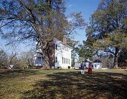 Latta House |
March 16, 1972 (#72000978) |
6 miles south of Huntersville on NC 2125 35°21′16″N 80°55′53″W |
Huntersville | |
| 58 | Elizabeth Lawrence House and Garden |  Elizabeth Lawrence House and Garden |
September 14, 2006 (#06000866) |
348 Ridgewood Ave. 35°10′47″N 80°50′36″W |
Charlotte | |
| 59 | Liddell-McNinch House |  Liddell-McNinch House |
December 12, 1976 (#76001330) |
511 N. Church St. 35°13′53″N 80°50′23″W |
Charlotte | |
| 60 | Louise Cotton Mill | December 31, 2013 (#13001027) |
1101 Hawthorne Ln. 35°13′29″N 80°49′06″W |
Charlotte | ||
| 61 | Matthews Commercial Historic District | Matthews Commercial Historic District |
August 22, 1996 (#96000928) |
157-195 and 156-196 N. Trade St., 118 E. Charles St. 35°06′59″N 80°43′20″W |
Matthews | |
| 62 | Mayes House |  Mayes House |
August 5, 1993 (#93000735) |
435 E. Morehead St. 35°11′26″N 80°50′54″W |
Charlotte | |
| 63 | Albert McCoy Farm |  Albert McCoy Farm |
November 2, 2000 (#00001291) |
10401 McCoy Rd. 35°22′01″N 80°53′10″W |
Huntersville | |
| 64 | Samuel J. McElroy House | 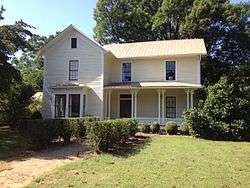 Samuel J. McElroy House |
February 21, 1991 (#91000078) |
10915 Beatties Ford Rd. 35°22′11″N 80°54′09″W |
Huntersville | |
| 65 | John Washington McKinney House | February 21, 1991 (#91000079) |
7332 Providence Rd. W. 35°03′39″N 80°48′17″W |
Charlotte | Destroyed[6] | |
| 66 | Frank Ramsay McNinch House | June 3, 1999 (#99000670) |
2727 Sharon Ln. 35°09′39″N 80°49′09″W |
Charlotte | ||
| 67 | Mecklenburg County Courthouse | 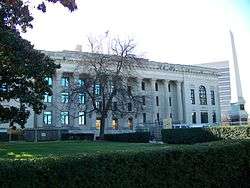 Mecklenburg County Courthouse |
May 10, 1979 (#79001734) |
E. Trade, Alexander, and E. 4th Sts. 35°13′16″N 80°50′15″W |
Charlotte | |
| 68 | Mecklenburg Investment Company Building | 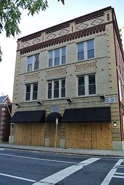 Mecklenburg Investment Company Building |
August 19, 1982 (#82003486) |
233 S. Brevard St. 35°13′22″N 80°50′32″W |
Charlotte | |
| 69 | Merchants and Farmers National Bank Building | March 1, 1984 (#84002344) |
123 E. Trade St. 35°13′36″N 80°50′32″W |
Charlotte | Demolished | |
| 70 | Green Morris Farm | February 21, 1991 (#91000080) |
Western side of NC 3628, approximately 1 mile south of its junction with Providence Rd. W. 35°02′56″N 80°47′56″W |
Charlotte | Destroyed[6] | |
| 71 | Morrocroft |  Morrocroft |
November 28, 1983 (#83003970) |
2525 Richardson Dr. 35°09′35″N 80°49′22″W |
Charlotte | |
| 72 | Myers Park Historic District |  Myers Park Historic District |
August 10, 1987 (#87000655) |
Roughly bounded by NC 16, E. and W. Queens Rd., and Lillington Ave. 35°11′33″N 80°49′59″W |
Charlotte | |
| 73 | North Charlotte Historic District |  North Charlotte Historic District |
March 16, 1990 (#90000367) |
Roughly bounded by the Southern Railroad, Herrin St., Spencer St., and Charles Ave. 35°14′44″N 80°48′19″W |
Charlotte | |
| 74 | Orient Manufacturing Company-Chadwick-Hoskins No. 3 |  Orient Manufacturing Company-Chadwick-Hoskins No. 3 |
August 15, 2006 (#06000721) |
311 E. 12th St. 35°12′12″N 80°49′53″W |
Charlotte | |
| 75 | R.F. Outen Pottery | April 24, 2015 (#15000183) |
430 Jefferson St. 35°06′54″N 80°43′44″W |
Matthews | ||
| 76 | Overcarsh House |  Overcarsh House |
July 21, 1983 (#83001896) |
326 W. 8th St. 35°13′58″N 80°50′30″W |
Charlotte | |
| 77 | Palmer Fire School |  Palmer Fire School |
August 25, 2004 (#04000906) |
2601 E. 7th St. 35°12′21″N 80°48′37″W |
Charlotte | |
| 78 | Pharrsdale Historic District | Pharrsdale Historic District |
February 20, 2002 (#02000057) |
Bounded by Biltmore Dr. Cherokee Rd., Providence Rd. and Scotland Ave. 35°11′28″N 80°49′20″W |
Charlotte | |
| 79 | Philanthropic Hall, Davidson College | .jpg) Philanthropic Hall, Davidson College |
April 13, 1972 (#72000975) |
Davidson College campus 35°29′57″N 80°50′47″W |
Davidson | |
| 80 | Pineville Commercial Historic District | 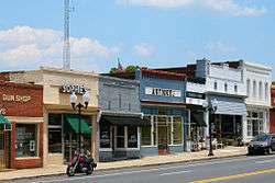 Pineville Commercial Historic District |
August 5, 2011 (#11000510) |
310-333 Main St. and 105-109 Dover St. 35°05′09″N 80°53′29″W |
Pineville | |
| 81 | Pineville Mill Village Historic District | August 8, 2011 (#11000511) |
Roughly bounded by Dover, Price & Hill Sts., Lakeview Dr. & Eden Ct. 35°04′50″N 80°53′44″W |
Pineville | ||
| 82 | Potts Plantation | January 5, 1998 (#97001561) |
South of Davidson and southwest of Cornelius, between NC 2693 and NC 115 35°28′45″N 80°50′13″W |
Cornelius | ||
| 83 | Providence Presbyterian Church and Cemetery |  Providence Presbyterian Church and Cemetery |
June 1, 1982 (#82003487) |
10140 Providence Rd. 35°04′11″N 80°46′18″W |
Matthews | |
| 84 | Ramah Presbyterian Church and Cemetery | February 21, 1991 (#91000081) |
NC 2439, 0.3 miles north of its junction with NC 2426 35°26′22″N 80°48′10″W |
Huntersville | ||
| 85 | Robinson Rock House Ruin and Plantation Site |  Robinson Rock House Ruin and Plantation Site |
January 22, 2009 (#08001365) |
Reedy Creek Park-2900 Rocky River Rd. 35°16′35″N 80°43′03″W |
Charlotte | |
| 86 | Rosedale |  Rosedale |
September 11, 1972 (#72000973) |
3427 N. Tryon St. 35°15′26″N 80°47′36″W |
Charlotte | |
| 87 | Edward M. Rozzell House |  Edward M. Rozzell House |
January 20, 2005 (#04001530) |
11647 Rozzelles Ferry Rd. 35°20′11″N 80°57′54″W |
Charlotte | |
| 88 | Savona Mill | December 2, 2014 (#14000989) |
528 S. Turner St. 35°14′29″N 80°52′02″W |
Charlotte | ||
| 89 | Seaboard Air Line Railroad Passenger Station | 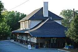 Seaboard Air Line Railroad Passenger Station |
October 24, 1980 (#80002887) |
1000 N. Tryon St. 35°14′02″N 80°49′59″W |
Charlotte | |
| 90 | Fritz Seifart House | December 20, 2006 (#06001141) |
421 Hempstead Place 35°12′02″N 80°48′56″W |
Charlotte | ||
| 91 | Siloam School | September 28, 2007 (#07001011) |
Western side of Mallard Highlands Dr., approximately ¼ mile south of its junction with John Adams Rd. 35°20′10″N 80°44′20″W |
Charlotte | ||
| 92 | Southern Asbestos Company Mills |  Southern Asbestos Company Mills |
January 30, 2008 (#07001500) |
1000 Seaboard St. 35°14′21″N 80°50′41″W |
Charlotte | |
| 93 | Speas Vinegar Company | Speas Vinegar Company |
August 12, 2015 (#15000530) |
2921 N. Tryon St. 35°15′05″N 80°48′45″W |
Charlotte | |
| 94 | St. Mark's Episcopal Church | March 1, 1984 (#84002410) |
NC 2004; also the southern side of NC 2004 east of its junction with NC 2074 35°20′52″N 80°52′51″W |
Huntersville | Second location represents a boundary increase of February 21, 1991 | |
| 95 | Steele Creek Presbyterian Church and Cemetery | 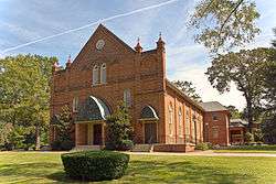 Steele Creek Presbyterian Church and Cemetery |
February 21, 1991 (#91000082) |
7407 Steele Creek Rd. 35°11′03″N 80°57′23″W |
Charlotte | |
| 96 | Joseph Sykes Brothers Company Building | 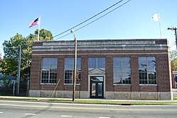 Joseph Sykes Brothers Company Building |
May 1, 2003 (#03000343) |
1445 S. Mint St. 35°13′09″N 80°51′38″W |
Charlotte | |
| 97 | Textile Mill Supply Company Building | 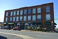 Textile Mill Supply Company Building |
February 5, 1999 (#99000091) |
1300 S. Mint St. 35°13′17″N 80°51′31″W |
Charlotte | |
| 98 | Union Storage and Warehouse Company Building | 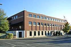 Union Storage and Warehouse Company Building |
January 11, 2001 (#00001640) |
1000 W. Morehead St. 35°13′42″N 80°51′31″W |
Charlotte | |
| 99 | VanLandingham Estate |  VanLandingham Estate |
October 13, 1983 (#83003971) |
2010 The Plaza 35°13′47″N 80°48′30″W |
Charlotte | |
| 100 | Victoria | 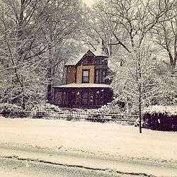 Victoria |
April 11, 1973 (#73001359) |
1600 The Plaza 35°13′26″N 80°48′37″W |
Charlotte | |
| 101 | Wesley Heights Historic District | 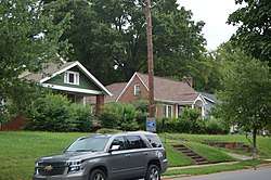 Wesley Heights Historic District |
November 29, 1995 (#95001397) |
Bounded by W. Morehead St., Woodruff Pl., Lela Ave., CSX RR tracks, Tuckaseegee Rd., W. Trade St. and S. Summit Ave. 35°13′58″N 80°51′48″W |
Charlotte | |
| 102 | White Oak Plantation | February 7, 1978 (#78001966) |
East of Charlotte on NC 2826 35°14′54″N 80°41′26″W |
Charlotte |
Former listings
| [3] | Name on the Register | Image | Date listed | Date removed | Location | City or town | Summary |
|---|---|---|---|---|---|---|---|
| 1 | Carolina Theater | August 14, 1986 (#86001637) | June 22, 1988 | 224-232 N. Tryon St. |
Charlotte | ||
| 2 | Dinkins House | December 4, 1973 (#73001360) | May 31, 1995 | Northwestern side of NC 1126, 1.2 miles from NC 1136 |
Pineville | ||
| 3 | Thomas Trotter Building | May 23, 1985 (#85001129) | February 1, 1988 | 108 S. Tryon St. |
Charlotte |
See also
| Wikimedia Commons has media related to National Register of Historic Places in Mecklenburg County, North Carolina. |
References
- The latitude and longitude information provided in this table was derived originally from the National Register Information System, which has been found to be fairly accurate for about 99% of listings. Some locations in this table may have been corrected to current GPS standards.
- "National Register of Historic Places: Weekly List Actions". National Park Service, United States Department of the Interior. Retrieved on June 19, 2020.
- Numbers represent an ordering by significant words. Various colorings, defined here, differentiate National Historic Landmarks and historic districts from other NRHP buildings, structures, sites or objects.
- "National Register Information System". National Register of Historic Places. National Park Service. April 24, 2008.
- The eight-digit number below each date is the number assigned to each location in the National Register Information System database, which can be viewed by clicking the number.
- "North Carolina Listings in the National Register of Historic Places by County". North Carolina State Historic Preservation Office. 22 October 2008. Archived from the original on 30 November 2012. Retrieved 14 July 2009.

| Topics | |
|---|---|
| Lists by state |
|
| Lists by insular areas | |
| Lists by associated state | |
| Other areas | |
| Related | |
| |
Municipalities and communities of Mecklenburg County, North Carolina, United States | ||
|---|---|---|
| City | | |
| Towns | ||
| Unincorporated communities | ||
| Footnotes | ‡This populated place also has portions in an adjacent county or counties | |
This article is issued from Wikipedia. The text is licensed under Creative Commons - Attribution - Sharealike. Additional terms may apply for the media files.