National Register of Historic Places listings in Greene County, North Carolina
This list includes properties and districts listed on the National Register of Historic Places in Greene County, North Carolina. Click the "Map of all coordinates" link to the right to view a Google map of all properties and districts with latitude and longitude coordinates in the table below.[1]

Current listings
- This National Park Service list is complete through NPS recent listings posted June 19, 2020.[2]
| [3] | Name on the Register | Image | Date listed[4] | Location | City or town | Description |
|---|---|---|---|---|---|---|
| 1 | Benjamin W. Best House | February 3, 2006 (#05000349) |
2193 Mewborn Church Rd. 35°24′42″N 77°45′43″W |
Jason | ||
| 2 | Titus W. Carr House | November 25, 1987 (#87002013) |
SR 1244 35°32′14″N 77°40′46″W |
Walstonburg | ||
| 3 | Edward R. and Sallie Ann Coward House | March 6, 2002 (#02000131) |
NC 1405, 0.2 miles E of jct. with NC 1400 35°26′59″N 77°32′49″W |
Ormondsville | ||
| 4 | Greene County Courthouse | May 10, 1979 (#79001712) |
Greene and 2nd Sts. 35°27′20″N 77°40′13″W |
Snow Hill | ||
| 5 | Hardee House | September 22, 2014 (#14000703) |
515 L.A. Moye Rd. 35°29′13″N 77°31′30″W |
Ormondsville | ||
| 6 | Neoheroka Fort Site | 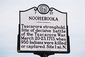 Neoheroka Fort Site |
July 17, 2009 (#09000529) |
Address Restricted 35°28′43″N 77°43′47″W |
Snow Hill | |
| 7 | St. Barnabas Episcopal Church | October 10, 1979 (#79003337) |
SE 4th St. and St. Barnabas Rd. 35°27′05″N 77°40′15″W |
Snow Hill | ||
| 8 | Snow Hill Colored High School | August 28, 2003 (#03000853) |
602A W. Harper St. 35°26′57″N 77°41′01″W |
Snow Hill | ||
| 9 | Snow Hill Historic District | September 14, 2000 (#00001122) |
Greene, Harper, 1st, 2nd, 3rd, and 4th Sts.; also W. Harper St. between W. 6th St. and W. 4th St. 35°27′08″N 77°40′15″W |
Snow Hill | Second set of boundaries represents a boundary increase of August 27, 2009 | |
| 10 | Speight-Bynum House | March 12, 1992 (#92000148) |
NC 1231 W side, 0.4 miles N of jct. with NC 1232 35°35′05″N 77°45′53″W |
Walstonburg | ||
| 11 | Zachariah School | May 4, 2005 (#05000377) |
NC 1239, 0.6 miles S o NC 1244 35°31′28″N 77°41′53″W |
Wooten's Crossroads |
See also
| Wikimedia Commons has media related to National Register of Historic Places in Greene County, North Carolina. |
References
- The latitude and longitude information provided in this table was derived originally from the National Register Information System, which has been found to be fairly accurate for about 99% of listings. Some locations in this table may have been corrected to current GPS standards.
- "National Register of Historic Places: Weekly List Actions". National Park Service, United States Department of the Interior. Retrieved on June 19, 2020.
- Numbers represent an ordering by significant words. Various colorings, defined here, differentiate National Historic Landmarks and historic districts from other NRHP buildings, structures, sites or objects.
- The eight-digit number below each date is the number assigned to each location in the National Register Information System database, which can be viewed by clicking the number.

| Topics | |
|---|---|
| Lists by state |
|
| Lists by insular areas | |
| Lists by associated state | |
| Other areas | |
| Related | |
| |
Municipalities and communities of Greene County, North Carolina, United States | ||
|---|---|---|
| Towns | | |
| CDP | ||
| Unincorporated community | ||
This article is issued from Wikipedia. The text is licensed under Creative Commons - Attribution - Sharealike. Additional terms may apply for the media files.