North Caucasus
est-
an
rakh-
an
Oblast
- Red: NC economic region, former NC krai, former NC military okrug
- Green: former NC military okrug
- Blue: NC economic region, NC federal okrug, former NC military okrug

The North Caucasus (Russian: Се́верный Кавка́з, IPA: [ˈsʲevʲɪrnɨj kɐfˈkas]) or Ciscaucasia is the northern part of the Caucasus region between the Sea of Azov and Black Sea on the west and the Caspian Sea on the east, within European Russia. Geographically, the Northern Caucasus (territory north of the Greater Caucasus Range) includes the Russian republics and krais of the North Caucasus. As part of the Russian Federation, the Northern Caucasus region is included in the North Caucasian and Southern Federal Districts and consists of Krasnodar Krai, Stavropol Krai, and the constituent republics, approximately from west to east: the Republic of Adygea, Karachay–Cherkessia, Kabardino-Balkaria, North Ossetia–Alania, Ingushetia, Chechnya, and the Republic of Dagestan.[1]
Geographically, the term North Caucasus also refers to the northern slope and western extremity of the Caucasus Major mountain range, as well as a part of its southern slope to the West (until the Psou River in Abkhazia). The Forecaucasus steppe area is often also encompassed under the notion of "Ciscaucasus", thus the northern boundary of the Forecaucasus steppe is generally considered to be the Manych River.
History
Ciscaucasus was historically covered by the Pontic steppe, mostly on fertile calcareous chernozyom soils, which has been almost completely tilled and grazed. It is bounded by the Sea of Azov on the west, and the Caspian Sea on the east. According to the Concise Atlas of the World, Second Edition (2008), the Ciscaucasus region lies on the European side of the "commonly-accepted division" that separates Europe from Asia.
The outer border of the Soviet Union's North Caucasus Krai was the same as that of present-day North Caucasus Economic Region (Raion) which includes an oblast (Rostov Oblast), two krais (Krasnodar Krai and Stavropol Krai), and seven republics. The former North Caucasus Military District (Okrug) also included Astrakhan Oblast, Volgograd Oblast, and the Republic of Kalmykia. Its administrative center was Rostov-on-Don until 10 January 1934, Pyatigorsk until January 1936, then Ordzhonikidze (today Vladikavkaz) and, from 15 December 1936, Voroshilovsk (today Stavropol).
In 2011, the Russian government has put forward plans to create a "North Caucasian version of Silicon Valley", at a cost of 32 billion rubles ($1.1 billion) as part of ongoing efforts to generate opportunities in the region.[2]
Image Gallery
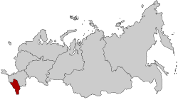 Location of the North Caucasian Federal District
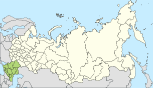 Map of former North Caucasus Military District (Okrug)
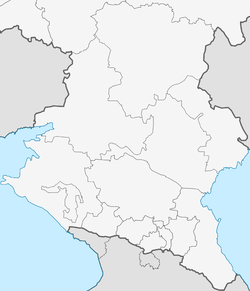
 Map of modern-day North Caucasus Economic Region (Raion)
See also
- Caucasus
- North Caucasian Economic Region
- North Caucasian Federal District
- North Caucasian Krai
- North Caucasian Military District
- Southern Federal District
- Kuban People's Republic
- Confederation of Mountain Peoples of the Caucasus
- Mountainous Republic of the Northern Caucasus
- Mountain Autonomous Soviet Socialist Republic
- North Caucasian Soviet Republic
- North Caucasian Federal University
- North Caucasian Railway
- List of clashes in the North Caucasus
- Dolmens of North Caucasus
References
- ↑ A small schematic map of the regions can be seen at
- ↑ "Проект «Кремниевой долины» на Северном Кавказе обойдется в 32 млрд рублей" Proekt "Kreminevoj doliny" na Severnom Kavkaze obojdetsya v 32 mlrd rublej [The "Silicon Valley" project in the North Caucasus will cost 32 billion rubles]. Forbes.ru (in Russian). Moscow: Forbes. 25 August 2011. Retrieved 27 March 2017.
Further reading
- In Quest for God and Freedom: Sufi Responses to the Russian Advance in the North Caucasus by Anna Zelkina
- Russia in the Modern World: A New Geography by Denis J. B. Shaw, Institute of British Geographers
External links


- Relations between The North and South Caucasus. Articles in the Caucasus Analytical Digest No. 27
Russia articles | ||||||
|---|---|---|---|---|---|---|
| History |
|  | ||||
| Geography | ||||||
| Politics | ||||||
| Economy |
| |||||
| Society |
| |||||
| ||||||
Soviet Union topics | |||||||||||||
|---|---|---|---|---|---|---|---|---|---|---|---|---|---|
| History |
|  | |||||||||||
| Geography |
| ||||||||||||
| Politics |
| ||||||||||||
| Economy | |||||||||||||
| Science | |||||||||||||
| Society |
| ||||||||||||
| |||||||||||||
| |||||||||||||